
IB Geography IA: 90 Examples and Guidance (2026)
Contents
The International Baccalaureate Diploma Programme (IBDP) offers a variety of assessments for students, including Internal Assessments (IAs), which are pieces of coursework marked by students’ teachers. The Geography Internal Assessment accounts for 25% of Standard Level students’ final grade and 20% of Higher Level students’ final grade. In this article, we will cover everything you need to know about the IB Geography IA, including the structure, assessment criteria, and some tips for success.
What is the IB Geography IA?
The IA is a written report, up to 2,500 words, based on a fieldwork question derived from any suitable syllabus topic. It involves the collection and analysis of primary and secondary data on a local scale, typically investigating two or three hypotheses.
The word count excludes elements such as footnotes (up to 15 words each), annotations (up to 10 words), map legends, tables, and appendices. According to IB Geography Tutors, students are expected to dedicate approximately 20 hours to complete the IA, regardless of whether they are at Higher Level (HL) or Standard Level (SL). The IA contributes 25% to the final grade for SL students and 20% for HL students.
Boost your grades with our revision platform, used by 100,000+ students!
Access thousands of practice questions, study notes, and past papers for every subject.
What are the assessment criteria for IB Geography IA?
The IB Geography IA Guide indicates that there should be 6 different sections to the IA, each of which carries a certain number of marks. The word counts are suggestions, so students can be flexible with each limit, as long as the overall report stays under 2,500 words.
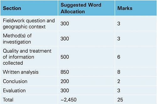
Source: Lanterna Geography IA Guide
Fieldwork question and geographic context: The fieldwork question should be well focused with a detailed, accurate explanation of the geographic context and be related to the syllabus. A good location map should be presented.
Method(s) of investigation: There should be a clear description and justification of the method(s) used for information collection. The method(s) used should be well suited to the investigation of the fieldwork question.
Quality and treatment of information collected: The information collected should be directly relevant to the fieldwork question and be sufficient in quantity and quality to allow for in depth analysis. The most appropriate techniques should be used effectively for both the treatment and display of information collected.
Written analysis: The report should reveal a very good level of knowledge and understanding. There should be a clear and well reasoned, detailed analysis of the results with strong references to the fieldwork question, geographic context, information collected and illustrative material. There should be a good attempt to explain any anomalies.
Conclusion: There should be a clear conclusion to the fieldwork question, consistent with the analysis.
Evaluation: Methods of collecting fieldwork information should be evaluated clearly. There should be valid and realistic recommendations for improvements or extensions. There may be some suggestions for modifying the fieldwork question.
Have a look at our comprehensive set of IB Geography SL and IB Geography HL Resources, developed by expert IB teachers and examiners:
📚 View IB Geography SL Study Notes
📚 View IB Geography HL Study Notes
📚 View IB Geography SL Past Papers
📚 View IB Geography HL Past Papers
90 Example IB Geography IA Fieldwork Questions
Here are a few examples of research questions or topics that could be used for a fieldwork-based IB Geography Internal Assessment (IA). Your teachers may have specific questions that they wish you to answer, based on a school-organised field trip, so make sure to check with your teacher or an IB Geography tutor to see how much choice you have over your investigation.
1. How does land use vary in different parts of a city?
- Students can map land use categories (e.g. residential, commercial, industrial) in selected neighbourhoods using surveys or GIS software.
- Investigate patterns such as zoning, gentrification, or urban sprawl and their underlying causes.
- Use statistical tools to compare land use densities and diversity across different areas. Analysing patterns and causes of land use change involves statistical methods and spatial analysis that an IB Maths tutor
can assist you with.
Key Points:
- Collect data via field surveys or digital tools like ArcGIS.
- Compare land use categories quantitatively (e.g. percentage of each type in a neighbourhood).
- Analyse factors such as economic activity, transport accessibility, or planning regulations.
2. What are the factors affecting water quality in a local river?
- Test water samples at multiple points along the river for indicators such as pH, turbidity, and nitrate levels.
- Link findings to potential sources of pollution like agriculture, industry, or urban runoff.
- Examine the downstream impacts on ecosystems and human activity.
Key Points:
- Measure physical and chemical parameters using portable testing kits or lab analysis.
- Map pollution hotspots and correlate with land use patterns near the river.
- Investigate policies or community efforts aimed at improving water quality.
3. How does urban heat island effect vary in different part of a city?
- Record temperature differences across urban and suburban areas using thermometers or temperature sensors.
- Relate findings to factors like vegetation cover, building materials, or population density.
- Propose strategies for mitigating urban heat, such as increasing green spaces or using reflective surfaces.
Key Points:
- Measure temperatures at consistent times for reliable comparison.
- Compare areas with varying levels of development, green cover, and infrastructure.
- Use aerial or satellite imagery to support findings on urban heat distribution.
4. How does the urban morphology of a city affect the travel behavior of its inhabitants?
- Survey residents to gather data on transport modes, travel times, and trip frequencies.
- Analyse the layout of roads, public transport networks, and land use zones using maps or GIS.
- Examine links between urban form (e.g. density, connectivity) and travel choices.
Key Points:
- Collect travel data through questionnaires or mobile tracking apps.
- Study the role of infrastructure and accessibility in shaping travel habits.
- Compare travel patterns across high-density and low-density areas.
5. How does vegetation vary along an elevational gradient?
- Record vegetation types, height, and density at various elevations using transects or quadrats.
- Investigate how factors such as temperature, soil type, or moisture affect vegetation.
- Compare biodiversity and species composition across altitude zones.
Key Points:
- Use GPS to ensure accuracy when marking sampling points.
- Identify dominant species at each elevation and note changes in structure or diversity.
- Link findings to climatic or soil variations along the gradient.
6. How does the land use changes affect the biodiversity of a wetland area?
Investigating the impact of land use changes on wetland biodiversity provides insights into how urban expansion, agriculture, or industrial activity can influence ecosystems. Students can study the relationship between habitat fragmentation and species diversity, offering a basis for conservation strategies.
Key Points:
- Map historical and current land use around the wetland using satellite imagery or field surveys.
- Conduct biodiversity surveys to record species richness and abundance.
- Analyse correlations between land use intensity and biodiversity indicators.
7. How do the factors affecting the air quality vary in different parts of a city?
This study involves identifying spatial variations in air quality and their causes, considering both natural and human influences. Students can evaluate the implications for public health and urban planning.
Key Points:
- Measure pollutants like particulate matter, nitrogen oxides, and sulphur dioxide using portable monitors.
- Link air quality data to traffic density, industrial zones, and green spaces.
- Use weather data to assess how wind or temperature affects pollutant dispersion.
8. How does the intensity of noise pollution vary in different parts of a city?
Urban noise pollution varies depending on land use, population density, and time of day. Students can assess how noise impacts quality of life and propose solutions for urban noise management.
Key Points:
- Use sound level meters to record decibel levels in residential, commercial, and industrial areas.
- Analyse temporal variations by comparing measurements during peak and off-peak hours.
- Correlate noise intensity with activities like traffic, construction, and recreational events.
9. What are the effects of a dam on downstream water flow and biodiversity?
Dams significantly alter river ecosystems, impacting both physical processes and biological diversity. This investigation explores how changes in water flow and sediment deposition affect aquatic and terrestrial life downstream.
Key Points:
- Measure water flow rates, sediment load, and biodiversity upstream and downstream of the dam.
- Study seasonal variations in flow and biodiversity to identify long-term trends.
- Analyse how changes in water availability affect local agriculture or community livelihoods.
10. How do soil properties change across an agricultural field?
Soil properties often vary spatially within agricultural fields due to factors like irrigation, fertilisation, or land management. Students can explore how these variations influence crop health and yield.
Key Points:
- Collect soil samples systematically along a transect or grid.
- Test for properties such as texture, nutrient levels, and pH in a laboratory.
- Compare findings to crop performance data to identify optimal soil conditions.
11. How does traffic density vary at different times and locations within a city?
This investigation examines how traffic patterns fluctuate throughout the day and across different areas of a city. By analysing variations, students can identify key influences such as road design, commuter behaviour, and urban planning.
Key Points:
- Count vehicles at fixed intervals and locations during peak and off-peak hours.
- Examine correlations between traffic density and factors like proximity to schools, businesses, or major roads.
- Compare variations across weekdays and weekends for additional insights.
12. What factors influence the distribution and abundance of a particular species in a local forest?
Understanding species distribution in a forest ecosystem requires evaluating environmental and biotic factors, such as habitat availability and predator-prey relationships. Students can use this study to highlight conservation priorities or biodiversity management.
Key Points:
- Conduct field surveys to record population density and habitat preferences.
- Measure variables such as soil type, light intensity, and moisture levels.
- Analyse interspecies interactions, such as competition or predation.
13. How does access to public transportation vary within a city?
Public transportation accessibility often reflects broader urban inequalities. By mapping transport networks, students can assess how spatial variation affects commuting patterns and urban connectivity.
Key Points:
- Map the density of public transport stops in different areas using GIS tools.
- Measure average walking distances to the nearest stops.
- Evaluate access disparities between residential, commercial, and industrial zones.
14. How does tourism impact the social, economic and environmental aspects of a beach?
Tourism shapes coastal environments in diverse ways, creating benefits and challenges for local communities. This study examines tourism's multifaceted impacts, balancing qualitative and quantitative analysis for a holistic view. An online IB English tutor can help in the analysis of qualitative data from interviews and the construction of a narrative that explores complex socio-economic dynamics.
Key Points:
- Survey tourists and locals to assess perceptions of tourism’s effects.
- Record the intensity of tourism activities and their physical impacts on the beach.
- Analyse economic data, such as job creation and income from tourism.
15. What is the impact of coastal defences on beach morphology?
Coastal defences play a critical role in mitigating erosion but often alter natural beach dynamics. Students can evaluate their effectiveness by studying changes in sediment distribution and beach profiles.
Key Points:
- Use transects to measure beach profiles in areas with and without defences.
- Collect data on sediment grain size and distribution along the shore.
- Assess long-term trends in erosion or accretion using historical maps or satellite images.
16. How are land use and urban sprawl related?
Urban sprawl often leads to significant changes in land use patterns, affecting social, economic, and environmental systems. This study investigates how urban expansion reshapes landscapes and examines its broader implications on communities and ecosystems.
Key Points:
- Analyse satellite images to map urban growth across multiple time periods.
- Investigate changes in land use (e.g., agricultural to residential) through field surveys.
- Evaluate the effects of urban sprawl on infrastructure, biodiversity, and local economies.
15. How do characteristics of a local market reflect the cultural and economic aspects of the community?
Local markets serve as microcosms of cultural and economic identity, offering insights into community lifestyles and priorities. By studying market dynamics, students can link economic behaviours to cultural values.
Key Points:
- Record the types of goods sold and their cultural significance.
- Observe price variations to infer economic disparities.
- Analyse buyer-seller interactions to understand social structures and norms.
18. What is the impact of waste management practices on a local river's health?
Effective waste management is crucial for preserving water quality in rivers. This study explores the link between waste disposal systems and the ecological health of a local river, highlighting potential areas for improvement.
Key Points:
- Review city waste management policies and assess their local implementation.
- Measure water quality indicators (e.g., pH, dissolved oxygen, turbidity) at different points along the river.
- Correlate water pollution levels with proximity to waste disposal sites.
19. How does a local wind farm affect the landscape and local residents?
Wind farms provide renewable energy but can also influence local communities and landscapes. This investigation evaluates visual and social impacts while considering their role in sustainable development.
Key Points:
- Assess public perceptions through surveys or interviews with local residents.
- Examine visual impacts by comparing photographs of the landscape before and after wind farm construction.
- Research the wind farm’s contribution to local electricity supply and energy goals.
20. What are the impacts of sea-level rise on a local coastal community?
Rising sea levels pose significant risks to coastal communities, from flooding to habitat loss. This study assesses vulnerability, explores community preparedness, and evaluates adaptation strategies.
Key Points:
- Map flood-prone areas and assess their level of risk using elevation and tidal data.
- Survey residents to understand their concerns and preparedness for sea-level rise.
- Analyse adaptation measures such as seawalls, mangrove replanting, or policy interventions.
21. How does the availability of green space vary in a city?
Green spaces provide essential ecological, social, and health benefits, yet their distribution and accessibility often vary across urban areas. This study evaluates the spatial distribution, quality, and use of parks and green spaces, highlighting inequities and opportunities for urban planning.
Key Points:
- Map green spaces using GIS and measure their size and proximity to residential areas.
- Assess accessibility by considering walking distances and transport links.
- Conduct field surveys to evaluate the quality of facilities and their usage patterns.
22. What impacts does a local factory have on air and water quality?
Factories can be significant sources of pollution, affecting nearby ecosystems and communities. This investigation analyses the environmental footprint of a local factory by evaluating air and water quality and examining regulatory compliance.
Key Points:
- Measure air quality indicators such as particulate matter and volatile organic compounds near the factory.
- Collect water samples upstream and downstream of the factory to test for pollutants.
- Review environmental regulations and assess the factory’s adherence to them.
23. How does soil erosion vary in different parts of an agricultural landscape?
Soil erosion reduces agricultural productivity and affects downstream ecosystems. This study measures erosion rates across an agricultural field and identifies contributing factors, helping to inform sustainable land management practices.
Key Points:
- Measure erosion indicators like topsoil depth and sediment accumulation.
- Compare erosion rates on slopes, flat areas, and near water bodies.
- Analyse the role of factors such as vegetation cover, ploughing techniques, and rainfall intensity.
24. What are the demographic characteristics of different neighborhoods in a city?
Demographic patterns reflect social and economic inequalities within urban areas. This investigation maps neighbourhood demographics and examines spatial disparities in age, income, ethnicity, and other population characteristics.
Key Points:
- Collect data from census records or local surveys on population characteristics.
- Map demographic variables to identify patterns and correlations with housing, employment, or services.
- Analyse inequalities between affluent and disadvantaged neighbourhoods.
25. How is a local glacier changing, and what are the impacts of these changes?
Glaciers are critical for water resources, tourism, and ecosystems, yet they are rapidly retreating due to climate change. This study tracks changes in a local glacier's size and melting rates while assessing their consequences for nearby communities and environments.
Key Points:
- Measure glacier dimensions using GPS or satellite imagery over time.
- Record meltwater flows and their impact on local water resources.
- Investigate secondary impacts, such as increased flooding risks or tourism decline.
26. How does energy use vary in different types of households in a community?
Energy consumption patterns can vary significantly based on household characteristics such as income, size, and type. This investigation analyses energy use for electricity, heating, and transport, identifying factors influencing consumption and potential areas for energy efficiency.
Key Points:
- Conduct surveys to collect data on energy use across households of varying sizes and types.
- Analyse how factors like income, household size, and insulation affect energy consumption.
- Investigate opportunities for renewable energy adoption and energy savings.
Get expert help with your IB Geography
The world's leading online IB Geography tutoring provider trusted by students, parents, and schools globally.
27. How do different farming practices affect soil health and crop yield?
Farming practices directly impact soil quality and agricultural productivity. This study compares the effects of organic and conventional farming on soil properties and crop yields, offering insights into sustainable farming approaches.
Key Points:
- Measure soil health indicators such as organic matter content, nutrient levels, and pH.
- Compare crop yields across fields with different farming practices.
- Assess long-term sustainability by examining soil erosion and fertility.
28. What are the social and economic impacts of a new infrastructure project in a city?
New infrastructure projects often reshape urban environments, influencing residents and businesses. This investigation evaluates the perceived benefits and drawbacks of a project, such as changes in traffic patterns, noise levels, and economic activity.
Key Points:
- Survey residents and businesses to gather opinions on the project's effects.
- Analyse impacts on property prices, commuting times, and local businesses.
- Assess long-term urban development trends influenced by the project.
29. What are the effects of deforestation on a local watershed?
Deforestation disrupts watershed ecosystems by altering water flow, increasing sedimentation, and degrading water quality. This study maps deforestation and evaluates its impacts on hydrological and ecological systems.
Key Points:
- Use satellite imagery to identify areas of forest loss over time.
- Measure streamflow, sediment levels, and water quality in affected areas.
- Analyse the broader impacts on local communities and biodiversity.
30. How are climate and microclimate conditions varying across a city?
Urban areas often exhibit significant microclimate variations due to factors like land use, building materials, and vegetation. This investigation explores spatial differences in temperature, humidity, and wind patterns, highlighting the role of urban design.
Key Points:
- Record temperature, humidity, and wind speed at multiple locations across the city.
- Compare data between densely built-up areas, parks, and waterfronts.
- Analyse the influence of urban features like heat-absorbing surfaces or green spaces on microclimate conditions.
31. What is the impact of a local mine on the landscape and local communities?
Mining operations can significantly alter the physical landscape and have profound effects on nearby communities. This investigation explores changes in landforms, water quality, and the social perceptions of those living near the mine.
Key Points:
- Use satellite imagery or fieldwork to map landscape changes caused by mining activities.
- Measure water quality in nearby rivers or lakes to assess contamination levels.
- Survey local residents about economic benefits, environmental concerns, and health impacts.
32. How does the composition of waste vary in different neighborhoods of a city?
Waste composition often reflects socioeconomic patterns within urban areas. This study examines the types of waste generated in different neighbourhoods and analyses links to income levels, consumption habits, and recycling practices.
Key Points:
- Conduct waste audits to categorise waste types (e.g., organic, recyclable, hazardous).
- Compare waste data across high-income and low-income neighbourhoods.
- Investigate the role of local recycling initiatives and their effectiveness.
33. What impacts does tourism have on a local historic site?
Tourism can be both a boon and a challenge for historic sites, contributing to preservation funding while increasing wear and tear. This study assesses the economic, social, and environmental effects of tourism on a chosen site.
Key Points:
- Survey tourists and locals to gather opinions on the site’s condition and tourism impacts.
- Analyse visitor data, such as peak times and ticket revenues, to evaluate economic benefits.
- Assess the effectiveness of conservation measures to mitigate damage caused by tourism.
34. How do urban green roofs affect building energy use and local biodiversity?
Green roofs offer a sustainable urban solution, providing insulation for buildings and creating habitats for local species. This investigation explores their dual benefits for energy efficiency and biodiversity in urban environments.
Key Points:
- Measure temperature differences between green roofs and traditional roofs to assess energy conservation.
- Conduct biodiversity surveys on green roofs to document species diversity and abundance.
- Evaluate the broader potential of green roofs in urban sustainability initiatives.
35. What are the impacts of a local natural disaster on a community?
Natural disasters can disrupt communities in numerous ways, highlighting the importance of preparedness and resilience. This study examines the physical, social, and economic effects of a recent disaster on a local community.
Key Points:
- Survey residents and officials to document the disaster’s immediate and long-term impacts.
- Analyse data on infrastructure damage, displacement, and economic losses.
- Evaluate the effectiveness of local disaster response and preparedness strategies.
36. How are invasive species affecting a local ecosystem?
Invasive species often disrupt native ecosystems, altering species composition and ecosystem functions. This study investigates the extent of invasive species in a local area and evaluates their impacts on biodiversity and ecological processes.
Key Points:
- Map the distribution of invasive species using field surveys or GIS.
- Record changes in native species populations or habitats affected by invasive species.
- Assess how the invasive species alter ecosystem functions like nutrient cycling or food webs.
37. What is the impact of local fishing activities on marine biodiversity?
Fishing activities can significantly affect marine ecosystems by altering species populations and food chain dynamics. This study examines the sustainability of fishing practices and their impact on marine biodiversity.
Key Points:
- Collect catch data to identify target species and bycatch.
- Survey fishers to understand fishing techniques and their adherence to regulations.
- Analyse changes in marine biodiversity, focusing on overfished or endangered species.
38. How do river characteristics change along its course?Rivers exhibit dynamic changes in physical and chemical characteristics from source to mouth. This investigation measures these variations and analyses their causes and impacts on surrounding landscapes.
Key Points:
- Measure variables like channel width, depth, velocity, and sediment size at multiple points along the river.
- Compare findings to theoretical models, such as the Bradshaw Model.
- Examine human influences, like dams or agriculture, on river characteristics.
39. How does light pollution vary in a city, and what are its impacts?
Light pollution is a growing urban issue, affecting human health, wildlife, and astronomical observations. This study measures light pollution across a city and evaluates its sources and consequences.
Key Points:
- Measure night sky brightness using a light meter or mobile app at multiple locations.
- Investigate sources such as streetlights, billboards, and residential lighting.
- Analyse impacts on human health (e.g., sleep disorders) and wildlife behaviour.
40. What is the impact of a new shopping mall on local businesses and traffic?
The opening of a new shopping mall can reshape local economies and urban traffic patterns. This study evaluates how local businesses and commuting habits have changed since the mall’s introduction.
Key Points:
- Survey local business owners to assess changes in footfall and revenue.
- Measure traffic flow at key intersections before and after the mall’s opening.
- Analyse social impacts, such as shifts in shopping behaviour or community engagement.
41. How does air quality vary near major roads in a city?
Air quality often deteriorates near busy roads due to vehicle emissions, affecting human health and environmental quality. This study examines how air pollution levels change with distance from major roads and analyses its broader implications.
Key Points:
- Measure pollutants such as nitrogen dioxide (NO₂), particulate matter (PM2.5), and carbon monoxide (CO) at set distances from major roads.
- Investigate correlations between traffic volume and pollution levels.
- Analyse health risks for people living or working near major roads.
42. How is a local wetland changing, and what are the impacts of these changes?
Wetlands are dynamic ecosystems that provide critical services like flood control and biodiversity support. This investigation tracks changes in wetland size and species composition and evaluates the consequences for local ecosystems and communities.
Key Points:
- Map historical and current wetland boundaries using GIS or aerial imagery.
- Survey species diversity and abundance to assess ecological health.
- Analyse impacts on water quality, flood management, and habitat loss.
43. How does public perception of climate change vary in a community?
Understanding public perceptions of climate change helps identify barriers to action and inform policy. This study evaluates community attitudes, knowledge, and the factors shaping these views, such as education or socio-economic status.
Key Points:
- Conduct surveys to gather data on awareness, beliefs, and concerns about climate change.
- Analyse variations in perception based on factors like age, occupation, or education level.
- Compare local perceptions to global trends to highlight unique challenges or opportunities.
44. What is the impact of a local power plant on regional air quality and health?
Power plants are significant contributors to air pollution, with potential health impacts for nearby populations. This study examines air quality changes linked to a local power plant and investigates their effects on community health.
Key Points:
- Measure pollutants such as sulphur dioxide (SO₂), nitrogen oxides (NOx), and PM2.5 in the region.
- Correlate emission data with air quality monitoring results.
- Investigate health outcomes, such as respiratory illnesses, through surveys or health records.
45. What are the impacts of a major highway on surrounding communities and the environment?
Highways influence their surroundings through noise, air pollution, and changes to local infrastructure. This study assesses the environmental and social effects of a highway, highlighting its impacts on quality of life and ecosystem health.
Key Points:
- Measure noise pollution and air quality at varying distances from the highway.
- Survey local residents about their experiences and concerns.
- Analyse changes in land use, such as urbanisation or green space loss, near the highway.
46. How does the level of particulate matter vary within a city?
Particulate matter (PM) pollution varies spatially within cities, influenced by sources such as traffic, industry, and construction. This study measures PM levels across different areas, evaluates health risks, and explores mitigation strategies.
Key Points:
- Measure PM2.5 and PM10 levels using portable air quality monitors in various locations.
- Identify sources of particulate matter, such as vehicular emissions or industrial activity.
- Assess the implications for public health and recommend potential solutions, like green barriers.
47. What impacts does a local landfill have on groundwater quality?
Landfills can leach contaminants into nearby groundwater, posing risks to local ecosystems and communities. This investigation examines water quality near a landfill and evaluates the extent of contamination.
Key Points:
- Test groundwater samples for indicators like pH, nitrate levels, and heavy metals.
- Map potential contamination zones based on proximity to the landfill.
- Assess the effectiveness of landfill liners and other management practices.
48. How does pedestrian footfall vary in different areas of a city at different times of the day?
Pedestrian activity reflects the socio-economic and functional dynamics of urban spaces. This study explores how footfall varies across locations and times, offering insights into urban mobility and planning.
Key Points:
- Count pedestrians at selected sites during peak and off-peak hours.
- Analyse the influence of factors such as land use, accessibility, and nearby amenities.
- Compare weekday and weekend patterns to understand temporal variations.
49. What are the impacts of a local ski resort on the mountain environment?
Ski resorts can alter mountain ecosystems, affecting vegetation, wildlife, and hydrology. This study evaluates the environmental impacts of a ski resort and reviews its management strategies for sustainability.
Key Points:
- Assess vegetation changes due to slope grooming and infrastructure development.
- Monitor wildlife activity and habitat disturbances in the area.
- Analyse water usage and pollution related to snowmaking and resort operations.
50. What is the impact of urban development on a local bird species?
Urban expansion often disrupts bird habitats, affecting populations and behaviour. This study investigates how a specific bird species responds to habitat loss and human disturbance in an urbanising area.
Key Points:
- Conduct bird population surveys in urban, suburban, and rural zones.
- Map habitat availability and fragmentation due to urban development.
- Assess behavioural changes, such as feeding and nesting patterns, in response to human activity.
51. How does beach litter vary with visitor numbers and beach management practices?
Beach litter is often influenced by visitor activity and the effectiveness of management strategies. This investigation examines the types and sources of litter, their impacts, and potential ways to reduce waste accumulation.
Key Points:
- Count and categorise litter items at different locations and times on the beach.
- Compare litter levels on managed and unmanaged beach sections.
- Investigate links between visitor numbers, litter types, and waste disposal facilities.
52. What are the effects of climate change on local farming practices and crop yields?
Climate change impacts agricultural productivity by altering weather patterns, water availability, and soil conditions. This study evaluates how farmers adapt to these challenges and the long-term implications for food security.
Key Points:
- Analyse historical climate data to identify trends in temperature and rainfall.
- Compare crop yield records over time to assess the effects of changing climate.
- Interview farmers to explore adaptive strategies like irrigation or crop diversification.
53. How does the level of carbon dioxide vary within a city?
Carbon dioxide (CO₂) levels can differ across urban areas due to traffic, industrial activity, and green space distribution. This study investigates CO₂ concentration patterns and identifies opportunities for mitigation.
Key Points:
- Measure CO₂ levels at sites with varying land uses, such as residential, commercial, and industrial zones.
- Correlate measurements with local traffic density and industrial emissions.
- Explore mitigation strategies, such as increasing urban greenery or reducing vehicular emissions.
54. What is the impact of a wind energy farm on local bird and bat populations?
Wind farms offer renewable energy benefits but can affect local wildlife. This study assesses the impact of wind turbines on bird and bat populations, focusing on mortality rates and ecological consequences.
Key Points:
- Monitor bird and bat mortality around wind turbines through systematic surveys.
- Identify high-risk periods or turbine locations contributing to wildlife collisions.
- Evaluate mitigation strategies like turbine placement or operational adjustments.
55. What are the impacts of river damming on the local communities and environment?
Damming rivers alters ecosystems and reshapes community dynamics by changing water flow, biodiversity, and access to resources. This study examines these effects and community perceptions of dam impacts.
Key Points:
- Measure changes in river flow rates and sediment deposition upstream and downstream of the dam.
- Survey local residents to understand the social and economic effects of damming.
- Assess changes in biodiversity, particularly aquatic species, due to altered habitats.
56. How does water availability and quality vary in different parts of a city?
Water resources within cities often show spatial disparities influenced by infrastructure, population density, and socio-economic factors. This investigation examines variations in water quality and access across city regions, highlighting potential inequalities and challenges in resource distribution.
Key Points:
- Measure water quality indicators like pH, turbidity, and nitrate levels in various city regions.
- Analyse water access in terms of supply reliability, costs, and infrastructure.
- Correlate findings with socio-economic data to identify patterns of inequality.
57. What are the socio-economic and environmental impacts of oil extraction in a local area?
Oil extraction sites can transform local economies while posing significant environmental risks. This study assesses the balance between economic benefits, such as employment, and environmental costs, such as habitat loss and pollution.
Key Points:
- Survey local residents to evaluate changes in employment and income due to oil extraction.
- Analyse environmental impacts like soil and water contamination, habitat destruction, or air pollution.
- Investigate perceptions of quality of life among affected communities.
58. How does the availability of amenities vary in different neighborhoods of a city?
The distribution of essential services and amenities often reflects broader urban inequalities. This study maps amenities across neighbourhoods and examines how their accessibility relates to socio-economic factors.
Key Points:
- Map the distribution of amenities like schools, hospitals, parks, and shops using GIS tools.
- Evaluate accessibility in terms of distance, transport options, and availability.
- Correlate the density of amenities with income levels, population density, or housing types.
59. What are the impacts of urban farming on local food security and community well-being?
Urban farming addresses food security challenges while fostering community resilience and well-being. This study explores its contribution to local food systems and evaluates the social and environmental benefits of these practices.
Key Points:
- Interview urban farmers about production practices, challenges, and motivations.
- Survey consumers to assess their perceptions of urban farming and its role in food security.
- Analyse community benefits, such as improved nutrition, social cohesion, and environmental education.
60. What are the impacts of sea traffic on the water quality in a coastal city?
Sea traffic, including shipping and recreational activities, can significantly impact coastal water quality. This study examines pollution levels in busy coastal areas and evaluates the ecological risks associated with increased sea traffic.
Key Points:
- Measure water quality parameters like oil residue, salinity, and turbidity near ports or shipping lanes.
- Identify sources of pollution, such as bilge water discharge or fuel leaks.
- Assess the impacts on marine biodiversity and coastal communities reliant on clean water.
61. What are the impacts of different land uses on soil erosion and water quality in a watershed?
Land use significantly influences watershed dynamics, affecting both soil stability and water quality. This study examines how various land uses, such as agriculture, urban areas, and forests, contribute to soil erosion and water quality changes, highlighting the environmental consequences of land use change.
Key Points:
- Measure soil erosion indicators like sediment accumulation and topsoil depth in areas with different land uses.
- Test water quality parameters such as turbidity, nutrient levels, and pH.
- Analyse how changes in land use (e.g., deforestation or urbanisation) influence watershed conditions.
62. What is the impact of rapid urbanization on a city's waste management system?
Rapid urbanisation often overwhelms waste management systems, leading to inefficiencies and environmental risks. This study investigates the challenges of waste collection, disposal, and recycling in a growing urban centre and explores potential solutions for sustainable waste management.
Key Points:
- Assess waste generation rates across different parts of the city.
- Evaluate the effectiveness of collection and disposal systems, including recycling initiatives.
- Identify challenges like landfill overuse, informal waste disposal, or inadequate infrastructure.
63. What are the impacts of climate change on a local endangered species?
Climate change poses significant threats to biodiversity, particularly for vulnerable species. This investigation monitors a local endangered species to assess the effects of habitat changes, altered climatic conditions, and other emerging threats.
Key Points:
- Track changes in the species’ population, distribution, and habitat quality.
- Identify threats such as temperature shifts, changing food availability, or habitat degradation.
- Evaluate conservation efforts and propose strategies to mitigate climate change impacts.
64. How does the quality of housing vary in different neighborhoods of a city?
Housing quality is a key indicator of urban inequality, reflecting disparities in socio-economic status and access to services. This study evaluates housing conditions across neighbourhoods and explores the factors driving inequalities in living standards.
Key Points:
- Survey housing conditions, including structural integrity, access to utilities, and overcrowding.
- Collect resident feedback on satisfaction with housing and neighbourhood services.
- Analyse links between housing quality and socio-economic factors like income and education levels.
65. What are the impacts of a local forest fire on the ecosystem and local communities?
Forest fires can have devastating effects on both ecosystems and human communities. This study assesses the immediate and long-term impacts of a local fire, including changes in vegetation, wildlife, and soil, as well as the socio-economic consequences for residents.
Key Points:
- Measure post-fire changes in vegetation cover, soil composition, and biodiversity.
- Survey local residents about economic losses, health effects, and recovery efforts.
- Analyse the effectiveness of response and rehabilitation strategies in restoring the ecosystem.
66. How do different types of surface affect urban runoff and water quality?
Urban surfaces, such as concrete, asphalt, and permeable materials, significantly influence the volume and quality of runoff during rain events. This study examines the relationship between surface types, urban flooding risks, and water pollution, providing insights into sustainable urban drainage systems.
Key Points:
- Measure runoff volume and quality (e.g., turbidity, pollutant levels) from various surfaces, such as roads, pavements, and green spaces.
- Analyse the role of impermeable surfaces in increasing urban flooding risks.
- Investigate mitigation strategies, such as permeable pavements or green infrastructure.
67. What are the impacts of plastic waste on a local marine environment?
Plastic waste poses significant threats to marine ecosystems, affecting biodiversity and ecosystem health. This investigation categorises plastic debris in a local marine environment and explores its sources, ecological impacts, and potential solutions.
Key Points:
- Count and categorise plastic waste items on the beach and in the water, noting differences by location.
- Identify major sources of plastic pollution, such as tourism, fishing, or urban runoff.
- Assess ecological impacts, such as ingestion by marine life, and evaluate strategies for waste reduction.
68. What are the effects of a local conservation area on wildlife populations and local communities?
Conservation areas play a critical role in protecting biodiversity and supporting sustainable livelihoods. This study examines changes in wildlife populations and habitats within a conservation area while analysing community perceptions and benefits.
Key Points:
- Monitor changes in wildlife populations using direct observation or camera traps.
- Assess habitat quality in terms of vegetation cover, food availability, and human disturbances.
- Survey local residents to understand their attitudes towards conservation efforts and economic impacts.
69. What is the impact of a new rapid transit line on commuting patterns and air quality in a city?
The introduction of rapid transit lines can transform urban mobility and improve environmental conditions. This study evaluates how a new transit line influences commuting habits and reduces air pollution in the surrounding areas.
Key Points:
- Survey commuters to compare travel modes, times, and costs before and after the transit line opening.
- Measure changes in air pollutants, such as nitrogen oxides (NOx) and particulate matter (PM2.5), near the transit line.
- Analyse broader impacts on traffic congestion and accessibility.
70. How are local coral reefs changing, and what are the impacts of these changes?
Coral reefs are vital ecosystems that support marine biodiversity and protect coastlines, yet they are increasingly threatened by human activities and climate change. This investigation monitors coral health and evaluates its implications for fisheries, tourism, and coastal defence.
Key Points:
- Measure coral cover, species diversity, and health indicators (e.g., bleaching levels) using underwater surveys.
- Assess the effects of coral degradation on fisheries productivity and tourism revenue.
- Analyse the role of coral reefs in reducing wave energy and preventing coastal erosion.
71. What are the effects of urban green spaces on local climate and biodiversity?
Urban green spaces play a significant role in mitigating heat, improving air quality, and supporting biodiversity in cities. This investigation examines differences in temperature, humidity, and species diversity between green spaces and built-up areas, highlighting their ecological and climatic benefits.
Key Points:
- Measure temperature, humidity, and air quality in green spaces and nearby urban areas.
- Conduct biodiversity surveys to compare species richness in green and non-green spaces.
- Analyse the role of green spaces in reducing urban heat island effects and supporting wildlife.
72. How is the quality of public transportation perceived by its users in a city?
Public transportation is a key component of urban mobility, but user satisfaction can vary significantly. This study evaluates the strengths and weaknesses of a city’s public transport system by gathering user feedback and analysing areas for improvement.
Key Points:
- Survey public transport users about punctuality, comfort, affordability, and accessibility.
- Identify patterns in satisfaction levels across different demographics or transport modes.
- Propose recommendations for improving the system based on user suggestions.
73. What is the impact of tourism on a local indigenous community?
Tourism can bring both benefits and challenges to indigenous communities, affecting their social structures, economies, and cultural practices. This study explores community perceptions of tourism and evaluates its impacts on livelihoods and cultural preservation.
Key Points:
- Survey community members to gather insights on economic benefits, cultural challenges, and social changes.
- Analyse the role of tourism in creating employment opportunities and promoting cultural awareness.
- Investigate potential negative impacts, such as cultural commodification or environmental degradation.
74. How does urban design affect the physical activity levels of residents in a community?
Urban design significantly influences residents’ lifestyles, particularly their physical activity levels. This investigation examines the relationship between urban features like parks, pavements, and bike lanes, and the frequency of physical activity among residents.
Key Points:
- Survey residents about their physical activity habits and their use of urban features.
- Map the distribution of parks, bike lanes, and recreational areas in the community.
- Analyse correlations between physical activity levels and accessibility to urban spaces.
75. How does the spatial distribution of crime vary in a city?
Crime patterns often reflect socio-economic inequalities and urban planning issues. This study investigates the spatial distribution of crime in a city, analysing correlations with factors such as income levels, population density, and land use.
Key Points:
- Analyse crime data by neighbourhood, identifying hotspots and patterns.
- Correlate crime rates with socio-economic indicators, such as income, education, and housing quality.
- Evaluate the effectiveness of crime prevention measures, such as surveillance or community policing.
76. What is the impact of local pesticide use on groundwater quality and biodiversity?
Pesticides can contaminate groundwater and disrupt local ecosystems by affecting flora and fauna. This investigation evaluates the extent of pesticide residues in groundwater and examines their effects on biodiversity and ecosystem health.
Key Points:
- Test groundwater samples for pesticide residues near agricultural areas.
- Survey local flora and fauna to identify any adverse effects, such as reduced biodiversity or health abnormalities.
- Analyse links between pesticide use patterns and ecological changes.
77. What are the impacts of a local festival on waste generation and local economy?
Festivals contribute to both economic growth and environmental challenges, particularly through waste generation. This study examines the balance between the economic benefits of a local festival and its environmental impacts.
Key Points:
- Measure the amount and composition of waste generated before, during, and after the festival.
- Survey attendees about their spending on local businesses and services.
- Evaluate waste management practices and propose solutions for reducing environmental harm.
78. How does the quality of street lighting vary within a city?
Street lighting affects safety, energy efficiency, and light pollution, yet its quality can vary across urban areas. This investigation assesses the spatial variations in lighting quality and their broader implications.
Key Points:
- Measure light intensity, coverage, and uniformity in different neighbourhoods.
- Analyse correlations between lighting quality and perceived safety or crime rates.
- Assess the energy efficiency of lighting systems and their contribution to light pollution.
79. What are the impacts of a local invasive species on biodiversity and ecosystem functions?
Invasive species can outcompete native species, altering ecosystem structures and functions. This study examines the spread of a local invasive species and evaluates its effects on biodiversity and ecological processes.
Key Points:
- Monitor the distribution and abundance of the invasive species across affected areas.
- Measure impacts on native species populations and habitat quality.
- Assess changes in ecosystem services, such as nutrient cycling or pollination, caused by the invasion.
80. How are sea surface temperatures changing in a local bay or estuary?
Changes in sea surface temperatures influence marine ecosystems and human activities like fishing and tourism. This investigation monitors temperature trends and evaluates their impacts on local marine life and livelihoods.
Key Points:
- Measure sea surface temperatures regularly over an extended period.
- Analyse impacts on marine biodiversity, such as shifts in species distribution or coral health.
- Investigate the effects of temperature changes on fisheries or recreational activities.
81. What are the impacts of a local renewable energy project on electricity prices and local attitudes?
Renewable energy projects can bring environmental benefits but also raise questions about costs and community acceptance. This study assesses how a renewable energy project affects electricity prices and local perceptions.
Key Points:
- Analyse electricity price trends before and after the project’s implementation.
- Survey residents to gauge their attitudes towards the project, including perceived benefits and challenges.
- Evaluate the project’s contribution to sustainability goals and energy independence.
82. How does the quality of public space vary in different parts of a city?
Public spaces can differ greatly in terms of maintenance, accessibility, safety, and functionality. This investigation explores how the quality of public space changes across urban areas and considers what these differences reveal about planning priorities and patterns of inequality.
Key Points:
- Assess public spaces using criteria such as cleanliness, seating, lighting, greenery, and accessibility.
- Compare parks, squares, or pedestrian areas in neighbourhoods with different socio-economic characteristics.
- Survey users to gather perceptions of safety, comfort, and attractiveness.
83. What are the effects of footpath erosion in a popular rural area?
Footpath erosion is a common issue in areas with high visitor numbers, especially where slopes, rainfall, and soil conditions make paths more vulnerable. This study investigates the extent of erosion and evaluates how effective local management strategies have been in reducing environmental damage.
Key Points:
- Measure path width, depth, and vegetation loss at selected points along a route.
- Compare heavily used sections with less disturbed areas nearby.
- Assess the role of slope, soil type, and visitor pressure in influencing erosion.
84. How does accessibility to healthcare services vary within a city?
Access to healthcare is an important aspect of urban geography and can reveal spatial inequalities in service provision. Students can investigate how easily residents in different parts of a city can reach clinics, hospitals, or pharmacies, and what this suggests about social equity and urban planning.
Key Points:
- Map healthcare facilities using GIS or digital mapping tools.
- Measure travel distance or journey time from different neighbourhoods to the nearest service.
- Compare accessibility in central and peripheral areas of the city.
85. What is the impact of riverbank management on channel stability?
Riverbank management strategies are often used to reduce erosion and protect nearby land uses, but their effectiveness can vary depending on local conditions. This investigation examines whether managed sections of a river show greater stability than unmanaged sections, using field measurements and visual evidence.
Key Points:
- Measure bank angle, vegetation cover, and signs of erosion at different river sites.
- Compare sections with hard engineering, soft engineering, and no visible management.
- Assess how management influences sediment movement and channel form.
86. How does the distribution of retail services vary in different parts of a settlement?
Retail services are often concentrated in particular locations depending on accessibility, demand, and land value. This study explores how the number and type of retail outlets change across a settlement and what this reveals about urban structure and consumer patterns.
Key Points:
- Record the location and type of retail services in selected areas.
- Compare the proportion of convenience, comparison, and specialist shops.
- Analyse how retail distribution relates to transport links, footfall, or residential density.
87. What are the impacts of recreational use on vegetation in a local park?
Frequent recreational use can place pressure on vegetation through trampling, soil compaction, and informal path creation. This investigation assesses how visitor activity affects plant cover and condition in different parts of a park, highlighting the environmental costs of urban leisure spaces.
Key Points:
- Measure vegetation cover, plant height, and bare ground in areas with different levels of use.
- Compare sites near paths, playgrounds, or sports facilities with quieter zones.
- Assess whether park management practices are helping to reduce ecological damage.
88. How does building height and spacing affect wind speed in an urban area?
Urban form can influence localised wind patterns by funnelling or blocking airflow between buildings. This study examines how wind speed varies in areas with different building heights and spacing, offering insights into microclimate and the impact of urban design.
Key Points:
- Measure wind speed at multiple sites with contrasting building densities and heights.
- Compare open spaces, street canyons, and more enclosed built-up areas.
- Analyse how urban structure affects comfort and environmental conditions for pedestrians.
89. What are the effects of seasonal changes on the flow characteristics of a local stream?
Streams often show seasonal variation in discharge, velocity, and channel conditions due to changing rainfall and temperature patterns. This study investigates how flow characteristics differ over time and considers the implications for erosion, flooding, and ecosystem processes.
Key Points:
- Measure stream velocity, width, depth, and discharge at the same site over different periods.
- Compare results across wetter and drier conditions.
- Assess how seasonal changes influence sediment transport and channel behaviour.
90. How does the level of environmental quality vary between different housing areas in a town?
Environmental quality often differs between residential areas due to variations in housing age, maintenance, traffic, and access to green space. This investigation compares the quality of different housing environments to identify spatial patterns and possible socio-economic influences.
Key Points:
- Use an environmental quality survey to score factors such as noise, litter, traffic, and greenery.
- Compare older and newer housing areas or areas of different housing density.
- Investigate how residents perceive the liveability of each area.
91. What is the impact of boardwalks and fenced paths on dune conservation?
Boardwalks and fenced paths are commonly used to reduce trampling and protect fragile dune systems in coastal areas. This study evaluates whether these management strategies are effective by comparing vegetation and surface conditions in protected and unprotected sections.
Key Points:
- Measure vegetation cover, dune height, and signs of trampling in different sections.
- Compare managed areas with nearby unmanaged areas.
- Assess whether visitor movement is being successfully controlled by the infrastructure.
Evaluate the potential of permeable surfaces to improve sustainable urban water management.
These are just a few examples, and it is important to note that the research question or topic should be selected based on your local context and your interests. Check with your teacher when you come up with your own fieldwork question to ensure it is suitable.
How can I do well in my IB Geography IA?
To do well in the IB Geography Internal Assessment, consider this list of tips from our top IB Geography Tutors:
1. Choose a Strong Research Question
- Select a research question that is both relevant and interesting to you.
- Ensure the question allows you to demonstrate key geographical concepts and skills.
- Use high-quality IB resources, such as IB Geography Q&A Revision Notes, to guide your research.
2. Plan and Conduct Research Effectively
- Use appropriate methods for data collection and analysis.
- Gather both primary and secondary data relevant to your investigation.
- Critically analyze and interpret the data.
- Evaluate the reliability and validity of your research methods.
3. Use Statistical and Analytical Tools
- Apply statistical tests such as:
- Spearman’s Rank (to measure correlation)
- Confidence Intervals (to assess data reliability)
- Mann-Whitney U Test (to compare two independent datasets)
- Present findings clearly using tables, charts, maps, and pictures.
4. Draw Meaningful Conclusions
- Reflect on your research question and hypothesis.
- Ensure conclusions are supported by the collected evidence.
- Relate findings back to the context of your investigation.
5. Structure and Present Your IA Clearly
- Use a well-organised format with a recognised referencing style.
- Include all required elements as per IB guidelines.
- Proofread and edit thoroughly to maintain clarity and coherence.
6. Seek Feedback and Manage Time Wisely
- Your teacher can review one draft—make sure it is your best effort.
- Incorporate feedback from an IB tutor to refine your IA.
- Manage time effectively to complete the IA on schedule and to a high standard.
How is the IB Geography IA graded?
It is graded by the student’s teacher, who is trained and certified by the International Baccalaureate organisation. The report is then sent to a moderator, who will check that the report adheres to the IB guidelines and that the grade awarded is appropriate.
Source: IB Geography Subject Brief
Conclusion
The IB Geography Internal Assessment is a vital component of the IBDP, requiring students to apply geographical theories and methods to real-world fieldwork investigations. With careful planning, thorough data collection, and strong analytical skills, students can produce a high-quality report that contributes significantly to their final grade. By selecting a well-defined research question, using appropriate statistical tools, and structuring the IA clearly, students can maximise their performance.
Ultimately, success in the IB Geography IA comes down to effective time management, critical thinking, and a well-supported analysis. Seeking feedback from teachers or IB Geography tutors can further refine the final report. With dedication and strategic preparation, students can confidently approach their IA, gaining valuable research skills that will benefit them beyond the IB programme.
Need help from an expert?
The world’s top online tutoring provider trusted by students, parents, and schools globally.
Study and Practice for Free
Trusted by 100,000+ Students Worldwide
Achieve Top Grades in your Exams with our Free Resources.
Practice Questions, Study Notes, and Past Exam Papers for all Subjects!
Need Expert Help?
If you’re looking for assistance, get in touch with one of our expert tutors who will be able to provide you with the support you need for your IB exams. We’ll be there every step of the way!

Charlie
Professional tutor and Cambridge University researcher

Written by: Charles Whitehouse
LinkedInCharles scored 45/45 on the International Baccalaureate and has six years' experience tutoring IB and IGCSE students and advising them with their university applications. He studied a double integrated Masters at Magdalen College Oxford and has worked as a research scientist and strategy consultant.