
Edexcel Specification focus:
‘The global distribution and causes of earthquakes, volcanic eruptions and tsunamis.’
Introduction
Earthquakes, volcanoes and tsunamis show distinct global patterns closely linked to tectonic activity and plate boundaries, shaped by dynamic processes deep within the Earth’s interior.
Global Distribution of Tectonic Hazards
Tectonic hazards are unevenly distributed across the globe, forming distinct geographical patterns largely aligned with plate boundaries. These hazards include:
Earthquakes
Volcanic eruptions
Tsunamis
Each of these hazards is primarily driven by plate tectonics, the movement and interaction of rigid lithospheric plates floating on the semi-molten asthenosphere.
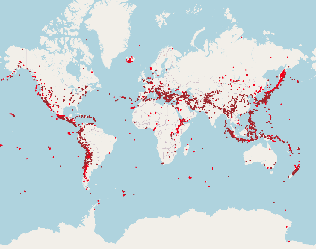
Map of global volcanoes (red triangles) and earthquakes (coloured dots), illustrating how both hazards concentrate along plate boundaries such as the Pacific Ring of Fire. This diagram includes all recorded events and volcanic centres, offering a comprehensive view of hazard distribution. source
Earthquakes: Distribution and Causes
Global Distribution
Earthquakes are primarily found along tectonic plate boundaries, particularly:
Convergent boundaries (e.g. the Pacific Ring of Fire)
Transform boundaries (e.g. the San Andreas Fault)
Divergent boundaries (e.g. the Mid-Atlantic Ridge)
Some intra-plate earthquakes also occur, although they are less frequent.
Causes of Earthquakes
Earthquakes are caused by the sudden release of energy from stress accumulation along faults or plate boundaries.
Earthquake: A sudden ground movement caused by the release of built-up stress along faults in the Earth's crust.
The movement can occur in various directions depending on the type of boundary:
At convergent boundaries, plates collide, causing intense pressure and deep-focus earthquakes.
At divergent boundaries, plates pull apart, producing shallow-focus earthquakes.
At transform boundaries, plates slide past each other, resulting in lateral displacement and shallow to intermediate earthquakes.
Volcanoes: Distribution and Causes
Global Distribution
Volcanoes are predominantly located along convergent and divergent plate boundaries, where magma reaches the surface due to plate interactions.
The Pacific Ring of Fire is a major volcanic belt with numerous subduction zones.
The Mid-Atlantic Ridge hosts volcanoes at a divergent plate boundary.
Some volcanoes are located intra-plate, typically at hotspots such as Hawaii and Iceland.
Causes of Volcanic Eruptions
Volcanoes form when magma generated in the mantle or lower crust rises to the surface.
At convergent boundaries, an oceanic plate subducts beneath another plate, melts due to increasing temperature and pressure, and forms magma that erupts at the surface.
At divergent boundaries, magma rises from the mantle as plates move apart, creating new crust and volcanic activity.
Hotspot volcanoes form independently of plate boundaries due to mantle plumes.
Volcano: An opening in the Earth’s crust through which magma, gases and ash are ejected.
Tsunamis: Distribution and Causes
Global Distribution
Tsunamis are typically concentrated around the margins of the Pacific Ocean, especially where subduction zones are present, such as:
Japan
Indonesia
Chile
These zones are highly active tectonic regions capable of generating large-magnitude undersea earthquakes.
Causes of Tsunamis
Tsunamis are most commonly triggered by undersea earthquakes at subduction zones. These earthquakes cause:
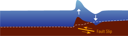
Caption: Cross-section showing how subduction-zone fault rupture uplifts the seafloor, displacing water to form tsunami waves. This public-domain illustration clarifies each stage from fault movement to wave initiation. Source
Sudden vertical displacement of the sea floor
Displacement of large volumes of water
Creation of long-wavelength waves that travel at high speed across ocean basins
As tsunami waves approach shallow coastal areas, they slow down and increase in height, causing devastating coastal inundation.
Tsunami: A series of large sea waves caused by the displacement of water, typically due to undersea earthquakes, volcanic eruptions or landslides.
Other less common causes of tsunamis include:
Volcanic eruptions (e.g. collapse of volcanic islands)
Underwater landslides
Meteorite impacts
Relationship Between Tectonic Hazards and Plate Boundaries
The distribution of earthquakes, volcanoes and tsunamis reflects the nature of different plate boundaries:
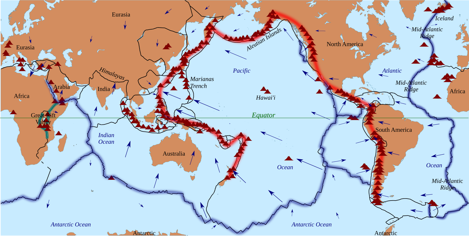
World map showing tectonic plate margins, including subduction zones, mid-ocean ridges, and transform faults. Volcano symbols and trench lines further illustrate where magmatic and seismic activity are most likely. source
Convergent Boundaries (Destructive)
Plates move towards each other
Subduction of oceanic crust beneath continental or oceanic crust
Characterised by:
Powerful earthquakes
Explosive volcanic eruptions
Tsunami generation
Divergent Boundaries (Constructive)
Plates move apart
Magma rises to form new crust
Characterised by:
Frequent but less powerful shallow earthquakes
Effusive (less explosive) volcanic eruptions
Transform Boundaries (Conservative)
Plates slide past each other
Crust is neither created nor destroyed
Characterised by:
Shallow, powerful earthquakes
No significant volcanic activity
Summary of Key Global Patterns
The Pacific Ring of Fire is the most active zone for earthquakes and volcanoes.
Mid-ocean ridges such as the Mid-Atlantic Ridge show volcanic and earthquake activity related to sea-floor spreading.
Himalayan region experiences high seismicity due to continental collision.
Tsunamis are generally found in areas with subduction zones, particularly around the Pacific Ocean.
Understanding these global patterns helps geographers predict hazard zones and prepare for tectonic events more effectively.
Practice Questions
Question 1 (2 marks):
Identify two types of plate boundary where earthquakes commonly occur.
Mark Scheme (2 marks total):
1 mark for each correct boundary type (max 2 marks)
Accept the following:
Convergent (destructive) boundary
Divergent (constructive) boundary
Transform (conservative) boundary
Do not accept “collision” on its own unless linked to convergent
Question 2 (6 marks):
Explain the global distribution of volcanoes and earthquakes and how this relates to plate boundaries.
Mark Scheme (6 marks total):
Award marks based on the quality and accuracy of explanation. Credit the following points:
1 mark: Recognition that most earthquakes and volcanoes occur along plate boundaries
1 mark: Description of convergent boundaries (e.g. subduction, intense earthquakes, explosive volcanoes)
1 mark: Description of divergent boundaries (e.g. shallow earthquakes, effusive volcanoes, mid-ocean ridges)
1 mark: Description of transform boundaries (e.g. lateral movement, shallow but powerful earthquakes)
1 mark: Mention of intra-plate activity or hotspots (e.g. Hawaii, not linked to boundaries)
1 mark: Use of named examples or reference to major regions (e.g. Pacific Ring of Fire)
Level-based marking if required:
Level 1 (1–2 marks): Basic description of distribution with limited link to plate boundaries
Level 2 (3–4 marks): Clear explanation of distribution with accurate reference to at least two types of boundary
Level 3 (5–6 marks): Detailed explanation with comprehensive understanding of all three boundary types and possible mention of exceptions/hotspots
FAQ
The Pacific Ring of Fire is a horseshoe-shaped zone where several major tectonic plates meet, including the Pacific, Philippine, North American, and Indo-Australian plates.
This region is dominated by subduction zones, where oceanic plates sink beneath continental or other oceanic plates. These processes generate intense volcanic and seismic activity.
Additionally, the Ring of Fire surrounds nearly the entire Pacific Plate, which is one of the fastest-moving plates on Earth, increasing stress accumulation and frequency of events.
These are known as intraplate or hotspot volcanoes. They occur when a stationary plume of hot mantle material rises through the lithosphere, melting it and creating magma.
As tectonic plates move over the hotspot, a chain of volcanoes may form:
Hawaii is a classic example, formed over a central Pacific hotspot.
Only the volcano above the hotspot is typically active; older ones become extinct as the plate moves.
No, while the majority of earthquakes are tectonic, some can occur due to other causes:
Volcanic activity: magma movement can fracture surrounding rock.
Human activity: mining, reservoir-induced seismicity, or fracking can trigger quakes.
Intra-plate stress: stress from plate interiors, not boundaries, can occasionally cause earthquakes.
These are usually less frequent and lower in magnitude than tectonic boundary events.
The scale of tsunamis depends on several factors at the subduction zone:
Amount of vertical displacement: Larger uplift displaces more water.
Shallow focus: Shallower earthquakes more effectively transfer energy to the seabed.
Length of rupture zone: A longer fault rupture displaces a greater water volume.
Seafloor topography: Certain shapes amplify wave generation and coastal impact.
Subduction zones with steep angles and high slip potential are particularly tsunami-prone.
No, the danger level depends on eruption style and local human factors:
Explosive eruptions (e.g. at subduction zones) pose greater hazards than gentle effusive eruptions (e.g. at divergent boundaries).
Population density: Highly populated regions near volcanoes face greater risk.
Monitoring and preparedness: Well-monitored regions (e.g. Japan) can mitigate impacts more effectively.
Geology and climate: Loose volcanic material and heavy rainfall can trigger deadly lahars.
So while the tectonic setting determines eruption style, human and environmental factors shape the risk.
