
Understanding how human activities, especially urbanisation, deforestation, and channel modifications, affect flood risk is crucial in managing and mitigating the impact of floods within drainage basins.
Urbanisation and Flood Risk
Urbanisation transforms the landscape, significantly impacting the hydrological cycle in various ways.
Impact on Surface Runoff
- Urbanisation replaces natural vegetation with impermeable surfaces like roads, buildings, and pavements.
- Impermeable surfaces increase surface runoff as they prevent water infiltration into the ground.
- Rapid runoff into drainage systems can lead to quicker and higher peak flow in rivers, increasing flood risk.
- Increased surface runoff can overwhelm urban drainage systems, leading to flash floods.
Alteration of Natural Drainage Systems
- Urban development often involves altering or replacing natural drainage patterns with artificial drainage systems.
- Concrete drains and sewer systems focus on efficiently removing water, which can overload rivers and streams during heavy rainfall.
- Natural watercourses are often straightened or enclosed, reducing their ability to absorb and delay the flow of water.
Heat Island Effect
- Urban areas tend to be warmer than their rural surroundings, a phenomenon known as the urban heat island effect.
- This can lead to increased evaporation rates and sometimes more intense and frequent rainfall events.
- The alteration in local climate patterns due to urban heat islands contributes indirectly to increased flood risk.
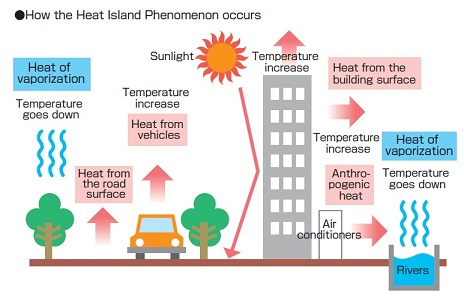
Image courtesy of gardinergreenribbon.com
Deforestation and Flood Risk
Deforestation affects the water balance in a catchment area and can significantly increase flood risk.
Loss of Natural Water Absorption
- Trees and forest floors play a vital role in intercepting and absorbing rainfall.
- The removal of vegetation cover, as seen in deforestation, diminishes this natural absorption capacity, leading to higher surface runoff.
- Deforestation often results in a more rapid and higher peak discharge in rivers, contributing to increased flood risk.
Soil Erosion and Sedimentation
- Trees and vegetation protect soil from erosion by rainfall.
- Once removed, soils are more susceptible to erosion, leading to increased sediment load in rivers and streams.
- Sedimentation can reduce the carrying capacity of rivers, making them more prone to flooding even during normal rainfall events.
Impact on Evapotranspiration
- Trees contribute to the atmospheric moisture through evapotranspiration.
- The loss of this process due to deforestation can alter local and even regional climate patterns.
- Changes in rainfall patterns, potentially leading to more extreme weather events, can be partly attributed to large-scale deforestation.
Channel Modifications and Flood Risk
Modifications to river channels are often undertaken for various reasons but can have unintended consequences on flood risk.
River Straightening
- Rivers are often straightened to improve navigation, drainage, or for land reclamation purposes.
- Straightening (channelisation) speeds up water flow, reducing the time for infiltration and increasing flood peaks downstream.
- This can lead to more severe flooding, especially in areas downstream of the modifications.
Construction of Levees and Dams
- Levees are built alongside rivers to protect land from flooding.
- Dams are constructed to control river flow, often for water supply or hydroelectric power.
- These structures, while beneficial, can fail or be overtopped during extreme events, leading to catastrophic floods.
- Levees can also prevent floodwaters from spreading over floodplains, concentrating the flood risk downstream or elsewhere.
Impact on Natural Flood Plains
- Natural flood plains act as buffers during flooding, absorbing and spreading out floodwaters.
- Channel modifications often reduce the extent of these natural flood plains.
- Constraining rivers and reducing floodplain areas can exacerbate flood risks, as less area is available for water to disperse during flood events.
Case Studies
Urbanisation: Example of a Major City
- A detailed case study of a major city, such as London or Tokyo, can illustrate the impact of urbanisation on flood risk.
- Examination of specific urban developments like paving, construction of drainage systems, and their direct effects on local river systems.
- Study of historical flood events in the city and how urban development has altered the frequency and severity of these events.
Deforestation: A Tropical Rainforest Region
- An in-depth analysis of a tropical rainforest region, like the Amazon, where deforestation has significantly altered the local hydrological cycle.
- The relationship between deforestation and changes in soil erosion, sedimentation in rivers, and the consequent increase in flood risk.
- Review of regional climate changes due to deforestation and how this affects precipitation patterns and flood occurrences.
Channel Modifications: A Major River Basin
- Investigation of a major river basin, such as the Mississippi or Yangtze, where channel modifications have been extensive.
- Analysis of the long-term ecological and hydrological impacts of these modifications on flood risk.
- Evaluation of specific engineering projects like levee construction, river straightening, and dam building, and their implications for flood management.
In conclusion, understanding the human influences on flood risk is vital for effective flood management and mitigation strategies. By examining the impacts of urbanisation, deforestation, and channel modifications, this section provides a comprehensive insight into how human activities alter the natural dynamics of drainage basins and increase the susceptibility to flooding.
Practice Questions
Urbanisation significantly increases flood risk in drainage basins primarily due to the creation of impermeable surfaces like roads, buildings, and pavements. These surfaces prevent water from infiltrating into the soil, leading to increased surface runoff. This rapid runoff quickly enters drainage systems and rivers, resulting in higher and faster peak flows, often overwhelming the capacity of urban drainage infrastructure. Furthermore, urbanisation often involves altering natural drainage patterns, which disrupts the natural absorption of water and can lead to more severe flash flooding events. The urban heat island effect, a consequence of urbanisation, can also intensify rainfall events, thereby exacerbating flood risks.
Deforestation drastically increases flood risk in drainage basins by removing vegetation that plays a crucial role in water absorption and soil stabilisation. Trees and vegetation absorb significant amounts of rainfall, reducing surface runoff. When these are removed, more water flows directly into rivers, leading to increased and faster peak discharge. Deforestation also exposes soil to erosion, which can lead to increased sedimentation in rivers, reducing their capacity and making them more prone to flooding. Furthermore, deforestation impacts evapotranspiration, which is part of the water cycle. The reduction of evapotranspiration can alter local rainfall patterns, potentially leading to more intense and frequent rainfall, thus increasing flood risk.
FAQ
The removal of wetlands significantly increases flood risk in both urban and rural areas. Wetlands act as natural sponges, absorbing excess water during heavy rainfall and releasing it slowly, thus reducing flood peaks. They provide essential flood control by buffering and delaying the flow of water into rivers and streams. When wetlands are drained or filled for development or agriculture, this natural flood control mechanism is lost. The consequent increased runoff and reduced water absorption capacity lead to higher flood risks, as water is more quickly and directly channelled into rivers, causing them to overflow.
Agricultural land use influences flood risks in various ways. Traditional agricultural practices often involve altering the natural landscape, such as clearing vegetation for fields, which can increase surface runoff and erosion. The use of irrigation systems can modify the natural water balance in a region, potentially increasing the volume of water in local rivers and streams. Additionally, certain agricultural practices like overgrazing and deforestation for farming reduce land's ability to absorb water, thereby increasing runoff. Pesticides and fertilisers used in agriculture can also impact water quality, affecting river ecosystems and their ability to cope with floods.
Industrial land use contributes to increased flood risk in several ways. Firstly, industrial areas typically have a high concentration of impermeable surfaces like concrete and asphalt, which prevent water infiltration into the ground, increasing surface runoff into nearby water bodies. Secondly, industrial activities can lead to the alteration of natural landscapes and watercourses, often exacerbating the effects of flooding. Pollution from industrial areas can also affect the quality of water in rivers and streams, impacting their natural flow and capacity. Additionally, the storage of hazardous materials in industrial sites poses a significant risk during flood events, as they can lead to contamination of floodwaters.
The construction of underground infrastructure, such as subways and parking garages, in urban areas can significantly impact flood risk. These structures can disrupt the natural flow of groundwater and surface water, often leading to increased surface runoff. Underground infrastructure often requires waterproofing and drainage systems to prevent flooding, but during heavy rainfall, these systems can be overwhelmed, leading to floods. Additionally, such constructions may alter the natural water table, potentially increasing the vulnerability of surrounding areas to flooding. Moreover, the concentration of impervious surfaces around these structures exacerbates runoff, compounding the flood risk in urban settings.
Landscaping and urban green spaces can effectively reduce flood risk by enhancing the natural absorption of rainwater. The presence of plants, trees, and grassy areas increases soil permeability, allowing more water to infiltrate into the ground rather than running off into drainage systems. Green roofs, rain gardens, and permeable pavements are examples of green infrastructure that can absorb rainwater, reducing surface runoff and relieving pressure on urban drainage systems. These green spaces also provide additional benefits like reducing the urban heat island effect, which can decrease the intensity of rainstorms. Thus, integrating green spaces into urban planning is a crucial strategy for sustainable flood risk management.
