
Flood mitigation encompasses a comprehensive range of methods and strategies aimed at reducing the impacts of flooding. This key aspect of geography explores the intersection of human intervention, environmental management, and the challenges posed by natural water systems.
Introduction to Flood Mitigation
Flood mitigation involves a blend of strategies to lessen or avoid the detrimental effects of floods. These measures are critical in safeguarding lives, properties, and ecosystems from the destructive power of water.
Structural Measures
Structural measures in flood mitigation involve the construction of physical barriers and modifications to the landscape to control or redirect water flow. Key examples include:
- Dams and Reservoirs: These are constructed to regulate river flow, storing excess water during periods of heavy rainfall or melting snow. Dams help in controlling the release of water, thereby reducing the risk of downstream flooding.
- Levees and Floodwalls: These raised structures are built along the edges of rivers or coasts. Levees, typically earthen embankments, and floodwalls, often made of concrete, act as barriers to prevent floodwaters from inundating adjacent land.
- Channel Modification: This involves altering the course or shape of river channels to improve their capacity to handle large volumes of water. Methods include dredging to deepen channels, straightening meanders to speed up water flow, and widening channels to increase their volume.
- Flood Barriers: These include both permanent and temporary structures designed to prevent floodwaters from entering specific areas. Examples are gates that can be closed during flood threats and removable barriers that can be installed in anticipation of flooding.
Planning and Management
Non-structural measures are focused on planning, management, and policy-oriented strategies to mitigate flood impacts. These include:
- Land Use Planning: This involves regulating development in flood-prone areas. By controlling where and how buildings are constructed, the impact of flooding on human settlements can be minimized.
- Floodplain Zoning: Different areas within a floodplain are designated for specific uses according to their flood risk. High-risk zones might be reserved for parks or agriculture, while lower-risk areas can be used for residential and commercial development.
- Public Awareness and Education: Educating the public about flood risks and preparation is essential. This can include information campaigns, educational programs, and community engagement initiatives.
- Flood Insurance: Promoting or mandating flood insurance in flood-prone areas helps to mitigate the financial impact on individuals and communities when floods occur.
Case Studies of Flood Mitigation
To understand the application of flood mitigation strategies, we can examine two contrasting examples from different parts of the world.
Case Study 1: The Thames Barrier, United Kingdom
The Thames Barrier is a significant example of a structural flood mitigation strategy. It is a movable barrier system located on the River Thames in London, designed to protect the city from flooding caused by tidal surges and storm tides.
- Design and Functionality: The barrier consists of ten steel gates, each capable of being raised to form a continuous steel wall against high tides and storm surges. The gates are normally left open to allow uninterrupted river traffic and are only closed during high-risk periods.
- Impact: Since its completion in 1982, the Thames Barrier has been pivotal in protecting Central London from flooding, safeguarding a densely populated and economically vital area.
- Challenges and Adaptations: With the threat of rising sea levels and the increasing likelihood of extreme weather events due to climate change, there is an ongoing assessment of the barrier's adequacy. Plans for future reinforcement or replacement are being considered to ensure continued protection.
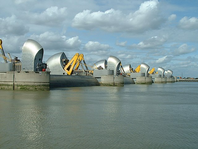
Image courtesy of Andy Roberts
Case Study 2: Bangladesh's Community-Based Approaches
Bangladesh, facing recurrent and severe flooding, employs a combination of structural and non-structural approaches, heavily focusing on community-based strategies.
- Community Engagement: In Bangladesh, local communities are actively involved in the planning and implementation of flood mitigation measures. This includes building local capacity to respond to flood emergencies and participating in decision-making processes.
- Early Warning Systems: Leveraging both modern technology and traditional knowledge, Bangladesh has developed effective early warning systems that alert communities to impending floods, allowing for timely evacuations and preparations.
- Elevated Housing and Infrastructure: In flood-prone areas, houses and essential infrastructure are often built on raised platforms to keep them above flood levels.
- Mangrove Plantation: Planting and conserving mangroves along coastal and riverine areas act as natural barriers against tidal surges and river flooding, while also providing ecological benefits.
Evaluating Flood Mitigation Strategies
The choice of flood mitigation strategies depends on various factors, such as the geographical context, type of flood risk, economic considerations, and social aspects. Structural measures, while providing direct and often visible protection, can be expensive and sometimes environmentally disruptive. In contrast, non-structural measures offer more sustainable solutions but require a longer-term commitment and extensive public engagement and education.
The examples of the Thames Barrier and Bangladesh's community-based approaches highlight the need for a balanced and adaptive approach to flood mitigation. These case studies illustrate how different strategies can be effective in different contexts, underlining the importance of local conditions and needs in determining the most appropriate flood mitigation measures.
In conclusion, managing flood risks through effective mitigation strategies is a critical challenge, especially in the context of climate change and increasing urban development. Combining structural and non-structural approaches, tailored to local needs and conditions, is essential for effective flood management. The Thames Barrier and Bangladesh's community-based approaches provide valuable insights into the diverse and complex nature of flood mitigation, demonstrating the importance of both technological solutions and community involvement in managing flood risks.
Practice Questions
Urban planning is a pivotal non-structural flood mitigation strategy. It involves regulating the development and use of land in flood-prone areas to minimise flood damage. Effective urban planning includes restricting construction in high-risk zones, promoting the development of green spaces like parks and natural reserves that can absorb floodwaters, and ensuring adequate drainage systems. These measures help to reduce surface runoff and lower the impact of floods. Additionally, enforcing building regulations, such as raised foundations in flood-prone areas, can significantly mitigate the damage caused by flooding. Urban planning, therefore, plays a critical role in reducing flood vulnerability in a sustainable and cost-effective manner.
The Thames Barrier is an effective flood mitigation measure, providing crucial protection for London against tidal surges and river flooding. Since its completion in 1982, it has successfully protected the city on numerous occasions, demonstrating its reliability and effectiveness. The barrier's design allows for adaptability to changing conditions, and its regular maintenance ensures continued functionality. However, with the anticipated rise in sea levels and the increased likelihood of extreme weather events due to climate change, there are concerns about its long-term efficacy. Future adaptations or enhancements might be necessary to maintain its effectiveness, but overall, the Thames Barrier remains a vital component of London's flood defence system.
FAQ
Structural flood mitigation measures, while effective in many cases, have certain limitations. They can be expensive to construct and maintain, requiring significant investment. There's also the risk of a false sense of security, leading to increased development in flood-prone areas. Environmental impacts are another concern; dams and levees can disrupt natural water systems, affecting ecosystems and wildlife habitats. Moreover, structural solutions might not keep pace with the changing patterns of flooding due to climate change, necessitating continuous assessment and adaptation. Reliance solely on structural measures can overlook the benefits of complementary non-structural approaches.
Yes, green infrastructure can be a vital flood mitigation strategy. It involves the use of natural processes and green spaces, such as parks, wetlands, and green roofs, to manage water and create more resilient urban environments. Green infrastructure absorbs and stores rainwater, reducing surface runoff and lowering the risk of urban flooding. This approach not only mitigates flood risk but also enhances urban biodiversity, improves air and water quality, and provides recreational spaces for communities. Integrating green infrastructure into urban planning is a sustainable and cost-effective way to address the challenges of flooding in densely populated areas.
Floodplain zoning is a strategic approach to land use that can significantly aid in flood mitigation. It involves dividing a floodplain into zones based on their flood risk, with regulations tailored to each zone. High-risk areas might be designated for low-impact uses like agriculture or recreation, while development in safer zones is subject to strict building codes and flood-proofing requirements. This ensures that vital infrastructure and dense population centres are not situated in areas with a high likelihood of flooding. Floodplain zoning reduces potential damage and costs associated with flooding, while also preserving the natural flood-absorbing capacity of the land.
Mangroves play a significant role in natural flood mitigation, especially in coastal regions. Their dense root systems act as natural barriers against storm surges and tidal waves, dissipating wave energy and reducing the velocity of water flow. Mangroves also help in stabilising coastlines by trapping sediments, which reduces erosion and land loss. Furthermore, they enhance biodiversity and provide habitats for various species. As effective carbon sinks, mangroves also contribute to climate change mitigation, indirectly influencing flood frequencies and intensities. Their preservation and restoration are, therefore, key aspects of integrated flood management strategies.
Early warning systems are crucial in flood mitigation as they provide timely information about potential flooding, enabling authorities and communities to prepare and respond effectively. These systems utilise a combination of meteorological data, hydrological models, and historical flood information to predict when and where floods might occur. Advanced technology, such as satellite imagery and remote sensing, enhances the accuracy of predictions. Upon receiving a warning, emergency services can mobilise, communities can evacuate or reinforce defences, and measures like the activation of flood barriers can be implemented. This proactive approach significantly reduces the risk of loss of life and property damage.
