
AP Syllabus focus:
‘Scales of analysis used by geographers include global, regional, national, and local levels for examining geographic issues.’
Geographers analyze phenomena at multiple scales to understand spatial patterns, reveal variation, and interpret processes. Each scale—global, regional, national, and local—offers distinct insights into geographic issues.
Levels of Geographic Scale
Geographic scale refers to the unit of analysis or the level at which geographic data and patterns are examined. Understanding scale is essential because patterns may appear differently depending on the level of observation.
Scale of Analysis: The level or scope at which geographic patterns and processes are examined, ranging from very broad (global) to very specific (local).
Geographers select a scale strategically, depending on the question they wish to answer, the type of data available, and the patterns they aim to uncover.
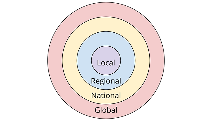
This diagram presents the four major geographic scales as nested circles, showing how local processes fit within regional, national, and global contexts. It reinforces the hierarchical nature of geographic analysis. The illustration includes no significant extra details beyond the content required by the syllabus. Source.
Global Scale
The global scale examines the Earth as a whole, focusing on worldwide processes, patterns, and relationships. At this level, the emphasis is on broad trends that transcend national borders.
Key Characteristics of the Global Scale
Worldwide patterns of cultural, economic, or environmental phenomena
Large data sets that generalize across continents and hemispheres
Connections and flows that link multiple world regions
Broad comparisons rather than fine-grained differences
Globalization: A process that creates increasing interconnections among people and places through economic, political, cultural, and technological exchanges.
The global scale is essential for understanding issues such as climate change, global supply chains, pandemic diffusion, and international migration flows.
Regional Scale
The regional scale focuses on areas larger than a single country but smaller than the entire world. A region may be defined by physical, cultural, economic, or political characteristics.
Types of Regions at the Regional Scale
World regions such as Latin America, Sub-Saharan Africa, or Southeast Asia
Functional regions such as economic zones or cultural spheres
Environmental regions such as biomes or climate zones
Analytical Uses of the Regional Scale
Revealing similarities among neighboring countries or areas
Identifying shared characteristics such as dominant languages, climates, or economic systems
Understanding interactions and flows that operate across multiple states
A regional perspective helps geographers examine spatial patterns that extend beyond national boundaries but remain more specific than global trends.
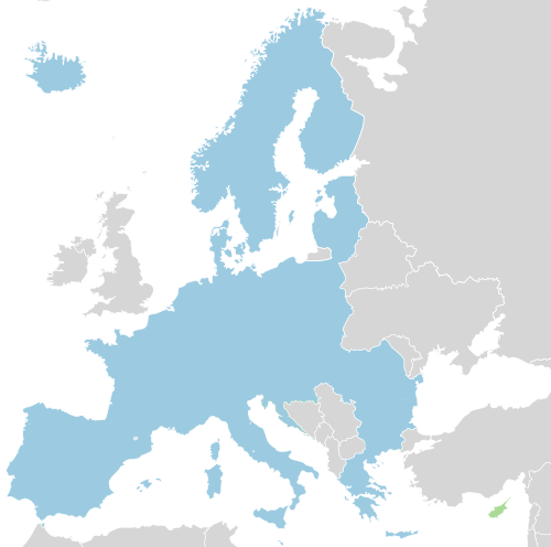
This map depicts the Schengen Area, illustrating how several nation-states can form a cohesive political region for analyzing mobility, policy, and interactions. It demonstrates the regional scale as an intermediate level of analysis. Some additional map distinctions appear, such as states legally required to join in the future, but these reinforce rather than distract from the core concept of regional organization. Source.
National Scale
The national scale examines patterns within the boundaries of a specific country. Governments, organizations, and researchers often use this scale to develop policies or analyze social and economic conditions.
Features of the National Scale
Uniform administrative boundaries and standardized data sets
Focus on country-level demographics, economies, and political structures
National policies and laws that shape patterns within the state
Comparisons between countries using standardized international metrics
Nation-State: A political unit in which the boundaries of a nation (a cultural group) align with the boundaries of a state (a political territory).
National-scale analysis is especially important for studying population trends, economic development, infrastructure, and public policy.
Local Scale
The local scale focuses on specific places such as cities, neighborhoods, or individual landscapes. This scale provides the most detailed resolution, revealing fine-grained variation hidden at broader levels.
Key Characteristics of the Local Scale
Highly detailed data, often field-collected or community-specific
Observation of micro-level patterns and spatial variability
Emphasis on individual behaviors, local decision-making, and distinct cultural landscapes
Ability to capture unique features of places, such as land use patterns or neighborhood identities
Cultural Landscape: The visible imprint of human activity on the environment, including buildings, roads, agricultural fields, and other human-made features.
The local scale is crucial for understanding spatial patterns like housing segregation, zoning decisions, local cultural practices, and land use changes.
Why Multiple Scales Matter
Geographers use multiple levels of scale because patterns and processes change depending on the scale at which they are observed. A trend that appears uniform globally may show significant diversity locally.
Key Insights of Multiscale Analysis
Patterns may be hidden, exaggerated, or reversed when shifting scales.
Different conclusions may emerge depending on the chosen scale.
Understanding scale prevents misinterpretation of data and spatial patterns.
Geographic issues often operate simultaneously at multiple scales.
Examples of How Scale Shapes Interpretation
A global decline in birth rates may mask significant national or local differences.
Regions may share similar climates but differ culturally or economically.
Local land use decisions can influence national environmental policies.
Global climate change is experienced differently at the regional, national, and local levels.
Using Scale in Geographic Inquiry
Geographers intentionally select a scale of analysis to frame research questions, interpret data, and draw conclusions. When analyzing a phenomenon, they often:
Identify the relevant scale or scales
Compare patterns across multiple levels
Relate local events to broader national, regional, or global processes
Evaluate how shifting scale alters interpretation
Choosing the appropriate level of scale helps geographers construct more accurate, nuanced understandings of spatial patterns and human–environment relationships.
Practice Questions
Question 1 (1–3 marks)
Explain the difference between the national scale and the regional scale in geographic analysis. Provide one example illustrating how a pattern may appear differently at each scale.
Question 1
1 mark: Identifies a correct distinction between national and regional scales (e.g., national refers to a single country; regional groups multiple countries or areas).
1 mark: Explains how scale affects geographic interpretation (e.g., broader similarities at regional level; more detailed variation at national level).
1 mark: Provides an appropriate example showing different patterns at the two scales (e.g., economic development appearing uniform regionally but varied nationally).
Question 2 (4–6 marks)
Discuss how examining a geographic issue at the global, national, and local scales can change the understanding of spatial patterns. Refer to one specific issue to support your answer.
Question 2
1 mark: Identifies that different scales reveal different levels of detail or variation.
1 mark: Describes how the global scale presents broad or generalised patterns.
1 mark: Describes how the national scale reveals variability between places within a country.
1 mark: Describes how the local scale provides fine-grained detail or distinct patterns not visible at broader scales.
1 mark: Clearly links the explanation to a named geographic issue (e.g., population change, climate impacts, migration).
1 mark: Provides a coherent, well-developed comparison showing how interpretations shift across the three scales.
FAQ
Geographers choose a scale based on the spatial extent of the phenomenon, data availability, and the level of detail needed to answer the research question.
They also consider whether analysing multiple scales will reveal hidden patterns. For example:
Global data may show broad trends.
National or local data may expose variation that changes the interpretation.
The choice of scale is therefore strategic, not fixed, and often involves comparing patterns across several scales.
Analysing a phenomenon at a scale that is too broad may obscure important differences. Local characteristics can disappear entirely when aggregated into national or regional figures.
Conversely, using a scale that is too narrow may exaggerate small differences and fail to show wider spatial trends.
This issue is known as the modifiable areal unit problem (MAUP), where the scale or boundaries chosen affect the results
Local-scale data tend to be highly detailed and often collected directly by individuals, municipalities, or small organisations.
Common examples include:
Neighbourhood demographics
Land use surveys
Local transport patterns
Global-scale data, by contrast, are usually aggregated from national datasets or international organisations and represent broad patterns such as world population distribution or global climate trends.
National boundaries are legally defined and shape data collection, policy decisions, and administrative divisions. Statistics are typically standardised within these borders.
Regional boundaries, however, may be cultural, economic, or environmental rather than political. For example, a cultural region may cut across several states.
Because regional boundaries are more flexible, interpretations at this scale vary depending on how the region is defined.
They use a multiscalar approach that involves:
Reviewing available data for each relevant scale
Mapping or visualising the patterns
Identifying differences or consistencies across scales
Determining how each scale adds context to the overall understanding
This method helps geographers trace relationships from local processes to global trends, ensuring that insights are not restricted to a single level of analysis.
