
AQA Specification focus:
‘Drainage basins as open systems: inputs (precipitation), outputs (evapo-transpiration, runoff), stores and flows, concept of water balance.’
This section explores the drainage basin as an open system, focusing on how water enters, moves through, and exits the system across time and space.
The Drainage Basin as an Open System
A drainage basin is a natural geographical unit defined by the area of land where precipitation collects and drains off into a common outlet, such as a river, bay, or other body of water.
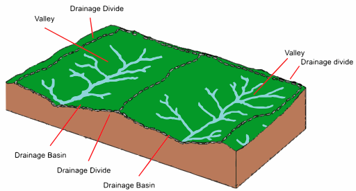
Figure: A schematic of a drainage basin showing the watershed boundary, tributary flows and outlet, highlighting inputs, stores, transfers and outputs in an open hydrological system. Source
It functions as an open system, meaning it both receives inputs and transfers outputs beyond its boundaries.
Open System: A system that exchanges both energy and matter with its surroundings.
In the context of the water cycle, the drainage basin facilitates key hydrological processes that operate on various temporal and spatial scales.
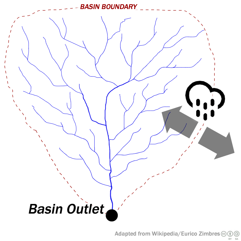
Graphic: A drainage basin delineated by dashed boundary lines with tributary streams and a rainfall arrow indicating precipitation input; also shows infiltration flow into soil. (Note: inset on soil-surface infiltration goes beyond syllabus detail.) Source
Inputs into the Drainage Basin
The primary input to a drainage basin is:
Precipitation (including all forms of moisture falling from the atmosphere — rain, snow, sleet, hail)
This input enters the system and initiates hydrological processes. Precipitation is variable and influenced by climatic patterns, topography, and seasonal change. It directly affects the magnitude of flow within the basin.
Outputs from the Drainage Basin
Two major outputs remove water from the basin:
Evapotranspiration: The combined process of water evaporating from surfaces and transpiring from vegetation.
Runoff: Water that flows over the land surface into rivers, eventually leaving the basin at its outlet.
Evapotranspiration: The loss of water from the Earth's surface through both evaporation and plant transpiration.
These outputs vary in response to land cover, seasonality, and weather conditions. For example, high vegetation density increases transpiration, while impermeable urban surfaces enhance surface runoff.
Stores in the Drainage Basin
Stores represent points where water is held temporarily during its passage through the system. Major stores include:
Interception (by vegetation, buildings)
Surface storage (in lakes, puddles)
Soil moisture (held in unsaturated soil)
Groundwater (saturated rock layers known as aquifers)
Channel storage (within rivers and streams)
These stores regulate the movement of water and affect response times to rainfall events.
Soil Moisture: The water held in the soil layer, available for plant use and evaporation.
Flows and Transfers within the System
Flows, also known as transfers, move water between stores within the basin. Key flows include:
Infiltration: Water seeping from the surface into the soil.
Percolation: Downward movement of water into deeper rock layers.
Throughflow: Lateral movement of water through soil.
Groundwater flow: Slow movement of water through aquifers.
Surface runoff (overland flow): Water moving over the land surface toward channels.
Channel flow: Movement of water through a river or stream.
Throughflow: The downslope movement of water through the soil layer, parallel to the surface.
Each flow has a different velocity and impact on lag time and flood response. For example, surface runoff occurs rapidly after intense rainfall, while groundwater flow provides a delayed input to rivers.
Concept of Water Balance
The water balance (also called water budget) represents the relationship between precipitation, evapotranspiration, and changes in storage within the basin over time.
Water Balance (P) = Q + E ± ΔS
P = Precipitation (mm)
Q = Runoff or streamflow (mm)
E = Evapotranspiration (mm)
ΔS = Change in storage (mm)
This equation is essential for understanding long-term water availability and the potential for flooding or drought conditions.
For example:
If precipitation exceeds evapotranspiration and storage, there will be increased runoff — common in wet seasons.
If evapotranspiration exceeds precipitation, storage is depleted, potentially leading to water deficits.
Dynamic Equilibrium and Feedbacks
A dynamic equilibrium exists when the inputs and outputs of the drainage basin are balanced over time, despite short-term fluctuations. However, this balance can be disrupted by:
Natural events such as storms, droughts, and seasonal changes.
Human activity such as urbanisation (which increases surface runoff) and deforestation (which reduces interception and transpiration).
Dynamic Equilibrium: A state of balance in a system when inputs and outputs fluctuate around an average condition over time.
Disruption to equilibrium can lead to feedback mechanisms:
Positive feedback may amplify effects (e.g. reduced vegetation cover increases runoff and erosion).
Negative feedback may restore balance (e.g. increased soil saturation reduces infiltration, leading to more runoff that limits further saturation).
Drainage Basin as a System: Summary of Components
To clearly visualise the open system nature of a drainage basin, consider its key components:
Inputs
Precipitation
Outputs
Evapotranspiration
Runoff
Stores
Interception storage
Surface storage
Soil moisture
Groundwater
Channel storage
Flows
Infiltration
Percolation
Throughflow
Surface runoff
Groundwater flow
Channel flow
These elements interact in a complex and dynamic way to control water distribution and movement across the basin.
Importance in Hydrology and Geography
Understanding drainage basins as open systems helps geographers:
Analyse hydrological responses to environmental change.
Monitor human impacts on local and regional water cycles.
Predict flooding potential through hydrograph analysis and water balance models.
Plan for sustainable water resource management.
Each basin responds uniquely depending on its physical characteristics (relief, geology, vegetation) and anthropogenic influences, making it a critical unit of study in both physical geography and applied environmental management.
Practice Questions
Define the term "drainage basin" and explain why it is considered an open system. (3 marks)
Mark Scheme (3 marks):
1 mark for a basic definition of a drainage basin:
e.g. Area of land where precipitation collects and drains into a river or other water body.1 mark for correctly identifying that a drainage basin allows inputs and outputs.
1 mark for explanation that water (and sometimes energy) enters and leaves the system, showing interaction with the surrounding environment.
Explain how different stores and flows operate within a drainage basin and influence its water balance. (6 marks)
Mark Scheme (6 marks):
Award up to 6 marks for the following relevant points:
1 mark for identifying key stores such as interception, soil moisture, surface storage, groundwater, and channel storage.
1 mark for identifying key flows such as infiltration, percolation, throughflow, surface runoff, and channel flow.
1–2 marks for clear explanation of how these interact (e.g. precipitation infiltrates soil and contributes to groundwater).
1–2 marks for explanation of water balance (relationship between precipitation, evapotranspiration, and changes in storage).
1 mark for using relevant terminology such as evapotranspiration or dynamic equilibrium where appropriate.
Candidates should demonstrate understanding of the interconnectivity between hydrological processes and the balance of inputs and outputs. Diagrams are not required but can be credited if they contribute to the explanation.
FAQ
Geology influences both storage and flow pathways. Permeable rocks like chalk and sandstone allow infiltration and groundwater flow, increasing lag time and reducing surface runoff.
Impermeable rocks such as granite reduce infiltration, leading to higher surface runoff and shorter lag times. Clay-rich soils can act similarly, slowing percolation and encouraging overland flow.
In areas with fissured limestone, rapid underground drainage may bypass surface flows altogether, affecting the drainage basin’s response to precipitation.
Several factors affect evapotranspiration rates:
Temperature: Higher temperatures increase evaporation and transpiration.
Vegetation type: Dense forests transpire more than grasslands.
Soil moisture availability: Water must be present in the soil for transpiration to occur.
Wind: Increases evaporation by removing saturated air.
Season: Evapotranspiration is generally higher in summer due to increased solar radiation.
These factors vary spatially and seasonally across a drainage basin.
A watershed defines the boundary of a drainage basin, separating one basin from another.
It is important because:
It determines the area contributing water to a particular river system.
Human activities near or across watersheds can impact neighbouring basins.
Watershed boundaries help in water resource planning, flood risk analysis, and catchment management.
Watersheds often follow high ground, such as ridges or hills.
Human activities can significantly shift the balance between inputs, outputs, and stores:
Urbanisation increases impermeable surfaces, enhancing runoff and reducing infiltration.
Deforestation lowers interception and evapotranspiration.
Agriculture may compact soil, decreasing infiltration and increasing overland flow.
Water abstraction reduces groundwater stores and alters river discharge patterns.
These changes can disturb dynamic equilibrium and increase flood or drought risks.
Vegetation influences multiple aspects of the hydrological cycle:
Interception: Leaves and stems capture rainfall, delaying its entry into the soil.
Transpiration: Plants return water to the atmosphere, reducing soil moisture.
Root systems: Improve soil structure, enhancing infiltration and reducing runoff.
Ground cover: Protects against soil erosion and slows surface flow.
Dense vegetation typically leads to greater storage and slower water movement through the system.
