
IB Syllabus focus:
‘Hadley, Ferrel, and Polar cells shape latitudinal temperature/precipitation patterns and resulting biome productivity; link circulation to global heat distribution.’
The Earth’s climate system operates through large-scale circulation patterns that redistribute heat and moisture, directly shaping biome distribution and ecological productivity across latitudes and continents.
The Tricellular Model of Atmospheric Circulation
The tricellular circulation model describes how energy and moisture move between the equator and the poles through three interconnected circulation cells in each hemisphere: the Hadley cell, the Ferrel cell, and the Polar cell. These cells explain latitudinal patterns of climate, which in turn determine biome distribution.
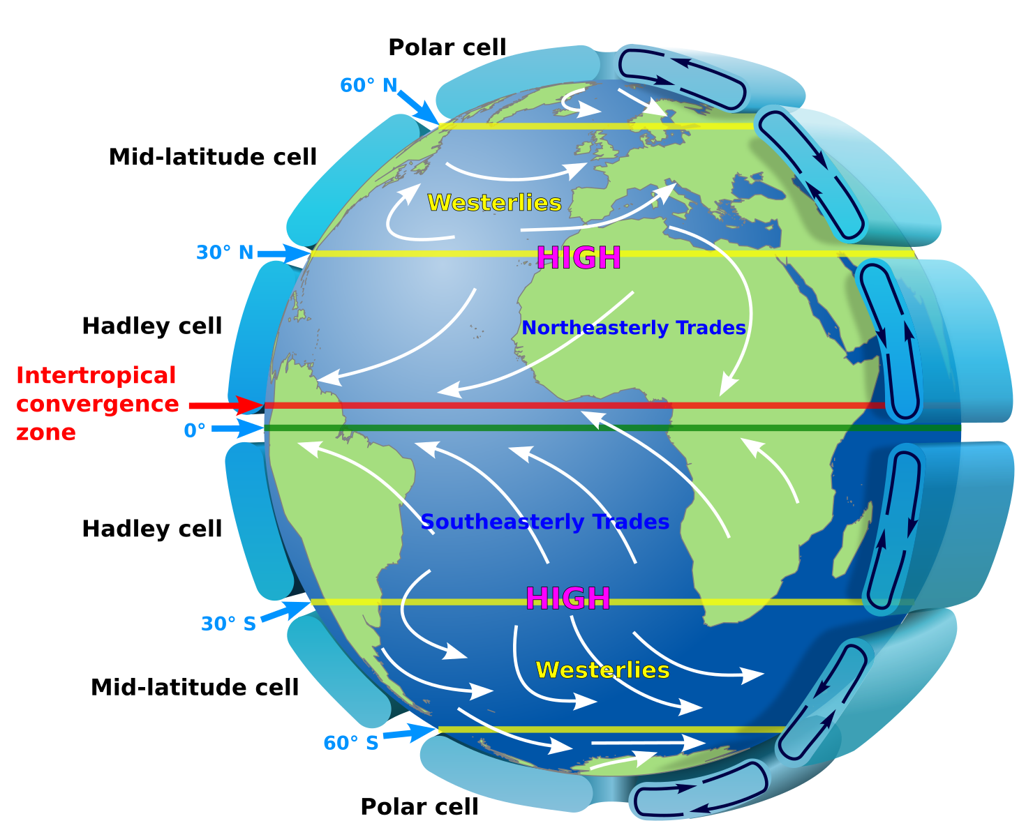
Labeled Hadley, Ferrel, and Polar cells illustrate rising and sinking branches, surface wind belts (trades, westerlies, polar easterlies), and the Intertropical Convergence Zone at 0°. The subtropical highs near 30° are shown where descending air promotes aridity—key to understanding downstream biome patterns. Minor additional labels (e.g., ‘HIGH’) reflect pressure belts discussed in standard circulation treatments. Source.
Tricellular Model: A global system of three circulation cells per hemisphere (Hadley, Ferrel, Polar) that move air, heat, and moisture, driving climatic zones and biome patterns.
The rotation of the Earth and differential heating of its surface create pressure belts, wind systems, and precipitation patterns that shape ecological regions worldwide.
The Hadley Cell
The Hadley cell dominates the tropics and subtropics, extending from the equator to roughly 30° latitude.
At the equator, strong solar insolation heats the Earth’s surface. Warm, moist air rises, creating low pressure and high rainfall.
Rising air cools, leading to condensation and precipitation that supports lush vegetation, such as tropical rainforests.
At about 30° latitude, the air descends, creating high-pressure zones with dry, stable conditions. These form deserts and semi-arid regions.
Hadley Cell: A tropical circulation cell where air rises at the equator, moves poleward, descends around 30° latitude, and returns as trade winds.
The Hadley cell explains why regions like the Amazon basin are biodiverse rainforests, while the Sahara Desert lies at subtropical latitudes.
The Ferrel Cell
The Ferrel cell operates between 30° and 60° latitude and functions as an intermediate zone influenced by both tropical and polar air masses.
Descending dry air at 30° latitude flows poleward along the surface.
At around 60° latitude, this air meets cold polar air, forming a polar front, where warm air rises, creating unstable weather.
The Ferrel cell produces temperate climates with seasonal variability.
These mid-latitudes support deciduous forests, grasslands, and mixed agricultural systems due to moderate rainfall and temperature variation.
Ferrel Cell: The mid-latitude circulation cell where air flows poleward at the surface, rises at 60° latitude, and moves equatorward aloft.
The Ferrel cell explains the mixed climatic conditions of regions like Western Europe and the eastern United States.
The Polar Cell
The Polar cell extends from 60° latitude to the poles.
Cold, dense air sinks at the poles, creating high pressure and dry conditions.
Surface winds blow outward and meet warmer Ferrel cell air at 60° latitude, rising to complete the circulation.
The polar regions are characterised by tundra and polar deserts, with very low productivity due to limited heat and moisture.
Polar Cell: A circulation cell in which cold air sinks at the poles, flows equatorward, rises at 60° latitude, and returns poleward aloft.
This system accounts for the extreme cold and low biodiversity in Arctic and Antarctic ecosystems.
Global Heat Distribution
The tricellular model is essential for understanding global heat distribution. The equator receives the most direct solar radiation, creating a surplus of heat energy. The poles receive far less radiation, creating an energy deficit.
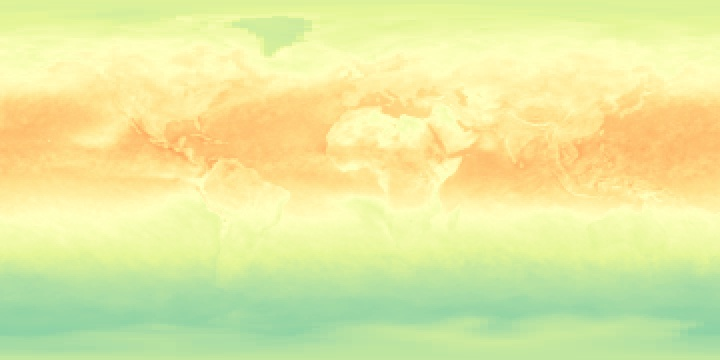
Monthly net radiation illustrates Earth’s heat engine: energy surplus in the tropics and deficit at high latitudes, driving poleward energy transport by the atmosphere and oceans. Colours indicate net gains (warm colours) and losses (cool colours). The monthly timestamp is extra detail; the latitudinal gradient it demonstrates is the key concept for IB ESS. Source.
Atmospheric circulation transfers surplus energy poleward and helps balance the Earth’s energy budget. Without this system, equatorial regions would become unbearably hot while the poles would grow even colder.
Key processes of heat distribution include:
Convection currents transporting warm air upward and poleward.
Latent heat transfer when water vapour condenses, releasing energy into the atmosphere.
Surface winds redistributing heat horizontally across latitudes.
Linking Circulation to Biome Patterns
Biome distribution directly reflects tricellular circulation patterns because climate defines the conditions under which ecosystems can thrive.
Equatorial regions (Hadley rising limb): High rainfall, high temperatures → tropical rainforests.
Subtropical zones (Hadley descending limb): Low rainfall, high insolation → deserts.
Mid-latitudes (Ferrel–Polar interaction): Seasonal climates → temperate forests and grasslands.
Polar regions (Polar descending limb): Extremely cold, low productivity → tundra and polar ecosystems.
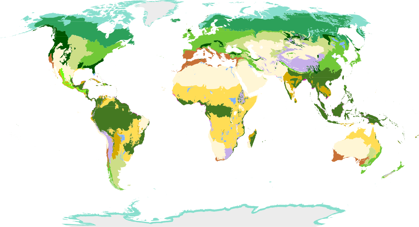
Global terrestrial biomes align broadly with latitude: equatorial humid biomes near the ITCZ, subtropical deserts near ~30°, temperate systems in mid-latitudes, and tundra near the poles. Colours distinguish the principal biome types to support pattern recognition at the IB level. The map includes finer sub-biome categories beyond the syllabus scope, which can be ignored if not needed. Source.
Biome: A large-scale ecological community defined by distinctive climate, flora, and fauna adapted to prevailing environmental conditions.
These predictable global patterns demonstrate how atmospheric circulation provides the framework for biome distribution.
The Role of the Coriolis Effect
The Coriolis effect—the deflection of moving air due to Earth’s rotation—shapes global wind patterns within the tricellular model.
In the Northern Hemisphere, winds are deflected to the right.
In the Southern Hemisphere, winds are deflected to the left.
This produces prevailing wind belts:
Trade winds in the tropics (east to west).
Westerlies in mid-latitudes (west to east).
Polar easterlies near the poles (east to west).
These winds strongly influence precipitation distribution and ocean currents, reinforcing biome locations.
Productivity and Biome Variability
Biome productivity—the rate of biomass production—varies with latitude due to circulation-driven climate.
High productivity: Equatorial regions, where consistent rainfall and warmth sustain dense vegetation.
Moderate productivity: Mid-latitudes, where seasonal variation allows diverse ecosystems but limits year-round growth.
Low productivity: Polar and desert regions, where extreme conditions restrict biomass accumulation.
The tricellular system therefore not only explains biome distribution but also their relative ecological efficiency and biodiversity.
Practice Questions
Question 1 (2 marks)
Identify two features of the Hadley cell that influence the distribution of tropical rainforests.
Mark scheme:
Rising warm, moist air at the equator (1 mark).
High rainfall from condensation and precipitation in equatorial regions (1 mark).
Question 2 (5 marks)
Explain how the tricellular circulation model helps to account for the global distribution of deserts and tundra.
Mark scheme:
At around 30° latitude, descending dry air in the Hadley cell creates high-pressure zones with low precipitation, leading to deserts (1 mark).
Subtropical deserts such as the Sahara are examples of this Hadley cell effect (1 mark).
At high latitudes, cold, dense air descends at the poles within the Polar cell, producing cold, dry conditions (1 mark).
This leads to tundra and polar deserts with very low productivity (1 mark).
Clear link made between circulation-driven climatic conditions and biome distribution (1 mark).
FAQ
The ITCZ is the area near the equator where the trade winds from both hemispheres converge.
This convergence causes air to rise, leading to cloud formation and heavy rainfall. The ITCZ shifts seasonally with the sun, creating wet and dry seasons in tropical regions.
Cold ocean currents off the western coasts cool the air above, reducing its ability to hold moisture.
Combined with descending dry air from the Hadley cell, this leads to arid conditions. Famous examples include the Atacama Desert in South America and the Namib Desert in Africa.
Jet streams are fast-flowing air currents found at the boundaries of circulation cells.
The subtropical jet occurs between the Hadley and Ferrel cells.
The polar jet occurs between the Ferrel and Polar cells.
These jets influence storm tracks and can shift the position of weather systems.
The tilt of the Earth (23.5°) shifts the regions of maximum solar heating north and south through the year.
This causes seasonal migration of the Hadley cell, the ITCZ, and associated rainfall patterns. Monsoon systems are a direct result of this shifting circulation.
The Ferrel cell is indirectly driven by the Hadley and Polar cells, making it more variable.
It depends on the mixing of warm tropical air and cold polar air at mid-latitudes. This instability explains why temperate regions experience frequent storms and highly changeable weather.
