
IB Syllabus focus:
‘Agriculture, deforestation and urbanization usually reduce evapotranspiration and increase runoff, raising flash-flood risk.’
Land use directly shapes the movement of water through the hydrological cycle, influencing flows and increasing flood risk. Human activities alter evapotranspiration, infiltration, and runoff patterns, creating far-reaching environmental consequences.
Human Activities and Altered Flows
Agriculture
Agricultural practices modify natural water flows in several ways:
Irrigation adds large amounts of water to soils, but this can increase surface runoff if poorly managed.
Soil compaction from machinery reduces infiltration and percolation, causing more water to remain at the surface.
Crop cover changes natural vegetation patterns. Seasonal crops often have lower evapotranspiration rates compared to forests or grasslands, altering atmospheric water returns.
Evapotranspiration: The combined process of water loss from soil and plants through evaporation and transpiration.
Agricultural expansion therefore contributes to reduced evapotranspiration and increased runoff, heightening downstream flood risk.
Deforestation
When forests are removed, the balance of flows in the water cycle changes dramatically:
Tree removal eliminates transpiration, reducing moisture returned to the atmosphere.
Forest canopies normally intercept rainfall, slowing infiltration. Without them, rainfall directly strikes soil, compacting it and accelerating runoff.
Root systems that enhance infiltration and stabilise soils are lost, leading to erosion and reduced water storage capacity.
Deforestation often creates conditions where heavy rainfall rapidly becomes flash flooding, overwhelming river systems.
Urbanisation
Urban growth has one of the most profound impacts on hydrological flows:
Impermeable surfaces (roads, pavements, buildings) prevent infiltration.
Storm drains rapidly channel water into rivers, bypassing natural storage.
Reduced vegetation cover lowers evapotranspiration and natural buffering against heavy rainfall.
Runoff: Water that flows across land surfaces into rivers and streams rather than infiltrating into the ground.
Urban areas therefore exhibit higher peak flows during storms, creating severe flood risks in densely populated regions.
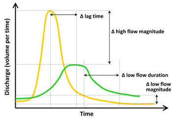
Hypothetical hydrographs for urban (yellow) and rural (green) streams illustrate how impervious cover increases peak discharge and shortens lag time. The altered hydrograph shape is a hallmark of urbanisation’s impact on catchment response. Use this to anchor ‘peak flow’, ‘lag time’ and ‘flash-flood’ vocabulary. Source.
Flood Risk and Flash Floods
Flash Flood Characteristics
Flash floods occur when surface runoff rapidly accumulates in rivers or low-lying areas following intense rainfall. They are intensified by:
Loss of vegetation
Soil compaction
Impermeable urban structures
Poor drainage systems
The lack of natural infiltration pathways means water moves quickly and with force, overwhelming both ecosystems and human settlements.
Factors Amplifying Flood Hazards
Topography: Steep slopes accelerate runoff in both deforested and urbanised landscapes.
Climate variability: Heavy rainfall events driven by climate change amplify risks where land use already disrupts flows.
River channel modification: Straightening or canalising rivers reduces storage capacity and accelerates flood peaks.
System-Level Impacts of Land Use Change
Altered Hydrological Balance
Land use change reduces the proportion of water entering groundwater stores and increases surface flows. This shift affects:
Water availability: Less groundwater recharge reduces supplies for agriculture and drinking water.
Soil health: Increased erosion removes fertile topsoil, weakening agricultural productivity.
Ecosystem function: Wetlands and floodplains, which normally absorb floodwaters, may degrade or vanish.
Case of Sustainable vs Unsustainable Use
Where land is managed sustainably, flows remain closer to a steady state, balancing infiltration, storage, and runoff. In unsustainable systems dominated by deforestation and urban sprawl, flows become imbalanced, with runoff far exceeding natural capacity.
Flash flood: A sudden, short-lived flood event resulting from intense rainfall and rapid surface runoff.
Such imbalances drive not only frequent floods but also long-term water insecurity.
These land-use changes alter the balance between infiltration, percolation, evapotranspiration and runoff—the key flows connecting stores in catchments.
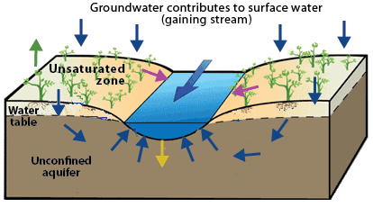
Cross-section showing precipitation partitioning into surface runoff, infiltration, percolation and groundwater flow that sustains stream baseflow. Use it to reinforce definitions and directions of key flows altered by land-use change. The diagram includes broader groundwater detail beyond the syllabus focus on land-use impacts. Source.
Mitigation and Management Approaches
Agricultural Solutions
Contour ploughing and terracing slow runoff on slopes.
Cover crops improve infiltration and maintain evapotranspiration during off-seasons.
Reduced tillage maintains soil structure and water-holding capacity.
Forest and Vegetation Strategies
Reforestation and afforestation restore transpiration and canopy interception.
Buffer zones along rivers stabilise soils and promote infiltration.
Urban Flood Management
Green infrastructure: permeable pavements, green roofs, and rain gardens enhance infiltration in cities.
Retention basins and constructed wetlands slow runoff and increase storage.
Zoning laws prevent development in high-risk floodplains.
These solutions highlight that while human land use alters flows, management and planning can reduce risks and restore water system balance.
Interconnectedness of Human and Natural Systems
Land use decisions illustrate the close relationship between human activity and natural hydrological processes. By reducing evapotranspiration and increasing runoff, societies unintentionally increase their own vulnerability to flash floods. Sustainable practices are therefore essential not only for environmental balance but also for protecting human populations and infrastructure.
Practice Questions
Question 1 (2 marks)
Define the term runoff and explain briefly how urbanisation influences this flow within the hydrological cycle.
Mark scheme:
1 mark for correct definition of runoff: water that flows across land surfaces into rivers and streams rather than infiltrating into the ground.
1 mark for stating that urbanisation increases runoff due to impermeable surfaces (e.g., roads, pavements, buildings) reducing infiltration.
Question 2 (5 marks)
Using named examples, explain how deforestation and agriculture can increase the risk of flash floods.
Mark scheme:
1 mark for identifying how deforestation reduces transpiration and canopy interception.
1 mark for explaining that loss of roots reduces soil infiltration and stability.
1 mark for linking agriculture to soil compaction and reduced infiltration/percolation.
1 mark for linking crop cover to reduced evapotranspiration compared to natural vegetation.
1 mark for overall explanation that these changes increase surface runoff and flash flood risk (must link to flash floods explicitly).
FAQ
Sandy soils allow rapid infiltration, so land use changes such as deforestation may still permit some groundwater recharge.
Clay-rich soils, however, have low permeability, so when combined with urbanisation or agriculture, they intensify runoff and reduce infiltration further, raising flood risks significantly.
Urban areas have:
High population density, so more people and property are exposed.
Impermeable surfaces that prevent infiltration, leading to rapid water accumulation.
Stormwater systems that channel water quickly into rivers, causing sudden peaks in flow.
These factors combine to create fast-moving floods with little warning time.
Vegetation slows rainfall impact by intercepting droplets on leaves and branches.
Roots bind soil, reducing erosion and improving infiltration.
Transpiration returns water to the atmosphere, lowering soil saturation.
The loss of vegetation through deforestation or urbanisation removes these protective functions, raising flood risk.
Natural vegetation, such as forests, maintains year-round evapotranspiration.
In agriculture, many crops are seasonal. When fields are bare after harvest, evapotranspiration drops sharply. This seasonal gap means more rainfall becomes runoff, particularly in wetter months, which can increase local flood potential.
Floodplains act as natural storage areas during high rainfall, spreading excess water across wide areas and reducing downstream flood peaks.
When floodplains are converted for agriculture or urban development, this storage capacity is lost. As a result, rivers rise more quickly and severely, amplifying flash-flood risk.
