
AP Syllabus focus:
‘Geographic data can be collected in the field by individuals or by organizations, producing observations and measurements.’
Field data collection underpins geographic inquiry by generating firsthand observations and measurements that help geographers understand spatial patterns, human activity, and environmental conditions across diverse landscapes with accuracy and context-rich detail.
Understanding Field Data Collection
Field data collection refers to the systematic gathering of geographic data directly from real-world locations rather than from remote or secondary sources.
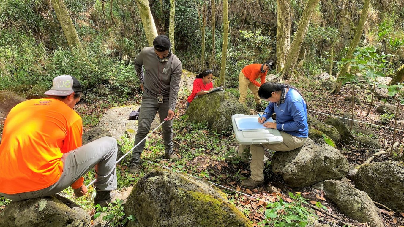
Students collect field data in a forest using measuring tapes and clipboards to record observations and measurements. This mirrors common geographic fieldwork methods used to quantify environmental or cultural features at specific locations. The scene includes extra ecological detail beyond the AP syllabus, but it still exemplifies core field data collection practices. Source.
It provides raw, location-specific information essential for analyzing spatial relationships, validating models, and producing high-quality geographic representations.
What Field Data Includes
Field data encompasses a wide range of measurements and observations, which may be qualitative, quantitative, or a combination of the two. Geographers select methods that match the research question, location type, and level of detail needed.
Quantitative data: Numerical information such as temperature, population counts, building heights, traffic volume, or soil moisture levels.
Qualitative data: Descriptive information such as perceptions of place, observed behaviors, cultural characteristics, or landscape features.
Key Terminology in Fieldwork
Field Observation: Systematic noting and recording of geographic phenomena as they appear in the real world.
Field observation allows geographers to capture spatial patterns in ways that remote or synthesized data often cannot replicate.
Purposes of Field Data Collection
Field data collection provides essential evidence for geographic analysis, allowing geographers to:
Document physical characteristics such as vegetation, landforms, and climate conditions.
Record human activities, including land use, settlement patterns, and transportation flows.
Verify or correct information obtained from maps, GIS, or remote sensing.
Develop deeper insights by experiencing place-based cultural and environmental contexts.
Produce original datasets for research in urban planning, environmental management, and cultural geography.
Major Methods of Collecting Field Data
Direct Measurement
Direct measurement involves using instruments to record precise environmental or spatial variables.
Thermometers, anemometers, and rain gauges for climate measurements
GPS receivers for exact coordinate recording
Rangefinders or measuring tapes for distances and dimensions
Soil probes or pH meters for environmental sampling
Direct measurement is valued for its precision, enabling geographers to quantify spatial variation with replicable results.
Surveys and Interviews
Surveys gather information from individuals or groups to understand human behavior, opinions, or demographic characteristics.
Survey: A structured set of questions designed to collect data from respondents about behaviors, attitudes, or characteristics.
Surveys help geographers study phenomena such as migration motivations, land-use decisions, or perceptions of neighborhood identity.
Interviews—structured, semi-structured, or unstructured—provide richer qualitative insights that deepen understanding of local contexts.
Field Sketching and Mapping
Field sketches capture the layout of landscapes and the spatial relationships between features.
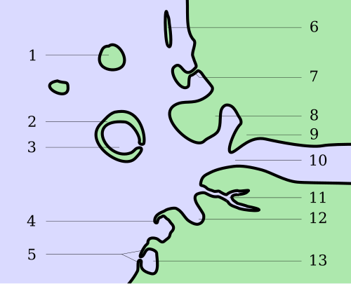
A simplified coastal field sketch highlights key landforms and labels them directly on the drawing. This kind of annotated sketch helps geographers record what they observe in the field and later relate it to maps or other data. Some of the specific coastal landforms labeled here go beyond AP Human Geography requirements, but the overall technique strongly reflects how field sketches support geographic observation. Source.
Geographers frequently create:
Sketch maps of settlements
Diagrams of land-use zones
Annotated drawings of environmental features
These sketches support later cartographic production and help validate remotely gathered information.
Participant and Non-Participant Observation
In participant observation, the geographer takes part in local activities to gain an insider’s perspective. Non-participant observation involves watching and recording behaviors without direct involvement.
These techniques are widely used in cultural geography, urban studies, and research on social interactions in public spaces.
Technologies That Support Field Data Collection
Mobile GPS Devices
Modern fieldwork heavily relies on handheld and smartphone-based GPS tools, which provide accurate coordinates and allow geographers to:
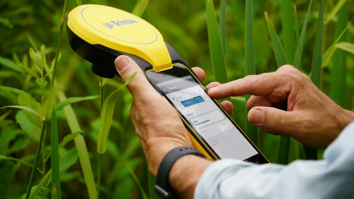
A handheld GNSS receiver with an integrated map display is used to capture precise location data during field surveys. Devices like this are common in GIS-based fieldwork, where point locations, lines, and polygons are recorded directly into digital databases. The advanced professional features shown exceed AP requirements, but the image clearly illustrates how GPS tools support geographic data collection. Source.
Geotag photos, sketches, and notes
Map features while navigating various terrains
Record routes, distances, and time-stamped observations
Digital Sensors and Mobile Apps
Mobile data-collection apps improve efficiency and accuracy by standardizing data entry. They often include:
Drop-down menus for attribute selection
Automatic coordinate capture
Photo and audio integration
Cloud-based synchronization for team projects
These tools minimize errors associated with manual transcription.
Drones for Local-Scale Observations
Drones provide high-resolution imagery that complements on-site observation. While technically part of remote sensing, their low-altitude, targeted imagery often supports field data collection by offering perspectives not visible from the ground.
Individuals vs. Organizations in Field Data Collection
Field data may be collected by individual geographers, students, or community members conducting localized studies, or by organizations engaged in large-scale, systematic collection.
Individuals often contribute fine-grained, localized insights.
Organizations such as government agencies, NGOs, or research institutions generate standardized datasets across broader regions.
Together, these scales of data contribute to more comprehensive geographic understanding.
Integrating Field Data into Geographic Analysis
Field data is most powerful when integrated with other geographic sources, such as GIS layers, demographic datasets, or satellite imagery. It enhances analytical accuracy by:
Filling gaps where remotely sensed data lacks detail
Validating models or map features
Revealing small-scale patterns invisible at larger scales
Ground-truthing environmental and human geographic information
When geographers combine field data with other sources, they strengthen their ability to interpret complex spatial patterns and produce reliable, evidence-based conclusions about human and environmental processes.
Practice Questions
Question 1 (1–3 marks)
Define field observation and explain one reason why it is important in geographic field data collection.
Mark scheme:
• 1 mark for a correct definition of field observation (systematic noting and recording of geographic phenomena in the real world).
• 1 mark for identifying a reason for its importance (e.g., provides firsthand, location-specific information).
• 1 mark for explaining how or why this reason matters (e.g., allows geographers to verify or complement secondary or remotely sensed data).
Question 2 (4–6 marks)
Discuss two different methods that geographers use to collect field data. For each method, explain how it contributes to understanding spatial patterns or human–environment interactions.
Mark scheme:
• Up to 2 marks for accurately identifying two distinct field methods (e.g., direct measurement, surveys, interviews, field sketching, GPS-based data collection).
• Up to 2 marks for describing how each method works (1 mark per method).
• Up to 2 marks for explaining how each method contributes to understanding spatial patterns or human–environment interactions (1 mark per method).
FAQ
Geographers assess what type of information is needed—quantitative measurements, qualitative insights, or both—and then choose a method that most effectively produces that information.
They also consider:
Accessibility of the site
Time and resources available
The required level of precision
Whether human subjects are involved and if ethical clearance is needed
Combining multiple methods is common when studying complex environments or interactions.
Accuracy begins with calibrated instruments and standardised procedures. Geographers often take repeated measurements to minimise error.
They also:
Cross-check results using more than one instrument where possible
Record contextual details such as weather or time of day
Use consistent data entry formats to avoid transcription mistakes
Data that appears inconsistent is usually revisited or verified with additional field visits.
Local cultural norms can shape whether people are willing to participate in surveys or interviews. Geographers adapt their approach to respect community expectations.
For example:
Using culturally appropriate language or translators
Seeking permission from community leaders
Modifying observation methods to avoid intrusiveness
Awareness of these factors helps reduce bias and improves the quality of qualitative data.
Observer bias can arise when a geographer’s expectations influence what they notice or record. Selection bias may occur if only easily accessible locations are studied.
To reduce bias, geographers may:
Use predefined observation checklists
Sample multiple locations systematically
Pair qualitative notes with quantitative measures
Compare observations with independent data sources
Training and peer review of field notes also help maintain objectivity.
Field data is typically geocoded using coordinates recorded via GPS, then uploaded into GIS software where it can be mapped, layered, and analysed alongside other datasets.
Challenges include:
Ensuring consistent coordinate formats
Converting handwritten notes into digital form
Managing varying levels of precision from different instruments
Avoiding spatial errors during data entry
Careful data cleaning and validation are essential before analysis begins.
