
AP Syllabus focus:
‘Formal regions share measurable characteristics (such as language or climate), creating areas with relatively uniform traits.’
Formal regions help geographers classify Earth’s surface by identifying areas with consistent, measurable characteristics, allowing clearer analysis of spatial patterns, regional identities, and geographic processes.
Understanding Formal Regions
Formal regions are areas defined by one or more objectively measurable traits, such as climate, language, political boundaries, or physical features. These characteristics are quantifiable, consistent across the region, and allow geographers to group places for analytical purposes.
Formal Region: A region defined by one or more measurable, homogeneous characteristics that maintain internal consistency across space.
Formal regions matter in geographic study because they provide a structured way to compare spatial patterns, understand environmental or cultural uniformity, and analyze how consistent characteristics influence human and physical landscapes. These regions are often used in regional planning, environmental research, demographic analysis, and the study of cultural or physical geography.
Key Traits of Formal Regions
Formal regions rely on uniformity, meaning that every part of the region displays the trait that defines it. This uniformity does not require perfect sameness—minor variation can exist—but the defining characteristic must remain dominant and measurable throughout.
Core Features
Measurable characteristics such as climate averages, political boundaries, language distributions, or physical landform features.
Internal consistency, meaning the defining trait is present throughout the area.
Clear criteria for inclusion or exclusion based on quantifiable data.
Stable boundaries that often remain relatively constant over time.
Comparability, enabling geographers to analyze differences between regions with shared or distinct traits.
Types of Formal Regions
Formal regions can be classified into several categories depending on the type of trait used to define them. Although these categories may overlap, each highlights a particular dimension of geographic uniformity.
Physical Formal Regions
Physical formal regions are defined by features of the natural environment. These are often based on observable or measurable environmental conditions.
Examples of criteria used include:
Climate zones (e.g., tropical, arid, continental climates) distinguished by temperature and precipitation patterns.
Landform regions such as mountain ranges, plains, or river basins.
Biomes, including deserts, grasslands, or tropical rainforests characterized by vegetation types and ecological conditions.
Watersheds, where all water drains into a common outlet.
Because physical data are highly measurable, physical formal regions are among the easiest types for geographers to delineate.
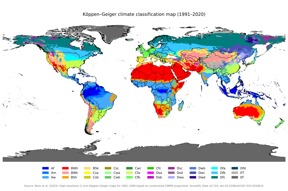
This Köppen–Geiger climate classification map shows formal regions of the world based on long-term temperature and precipitation patterns. Each color represents a distinct climate type, demonstrating how measurable environmental criteria delineate formal regions. The detailed sub-types extend beyond AP requirements but still reinforce regional uniformity. Source.
Cultural Formal Regions
Cultural formal regions focus on shared cultural traits, where a dominant cultural feature defines the region.
Common measurable criteria include:
Language: Regions where a specific language or language family predominates.
Religion: Areas where a particular faith has widespread adherence.
Ethnicity: Regions where an ethnic group forms a significant majority.
Cultural practices: Shared traditions, agricultural methods, or settlement patterns.
Cultural Trait: A characteristic of human action—such as language, religion, or social customs—that is learned and shared within a society.
Cultural formal regions help geographers understand how identity, tradition, and social cohesion shape landscapes and human interactions.
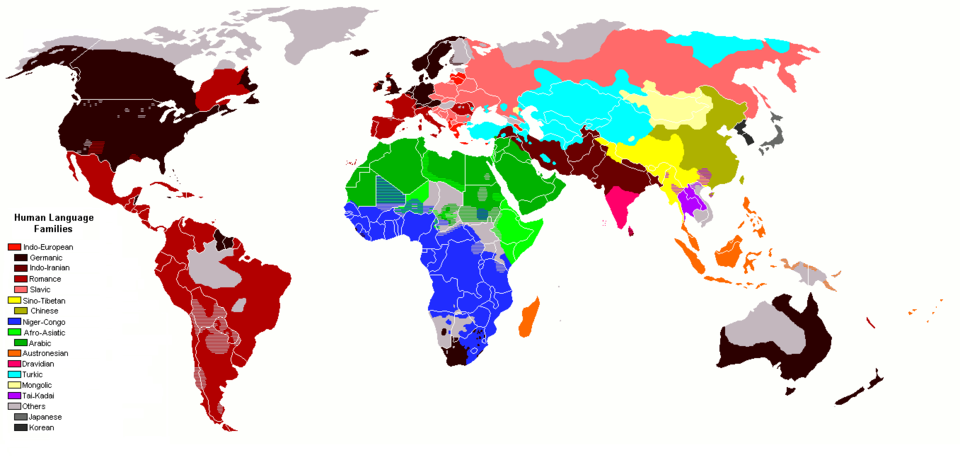
This map illustrates the global distribution of major human language families, highlighting how shared linguistic traits form cultural formal regions. Broad color blocks represent dominant families such as Indo-European, Afro-Asiatic, and Sino-Tibetan. While detailed distinctions exceed AP syllabus depth, they reinforce the concept of measurable cultural traits defining regions. Source.
Political Formal Regions
Political formal regions are established by government-defined boundaries, which are legally recognized and precisely mapped.
Examples include:
Countries with sovereignty and internationally recognized borders.
States or provinces with administrative authority within a country.
Counties or municipalities with local jurisdictions.
These regions are highly uniform regarding governance structure, legal systems, and administrative frameworks.
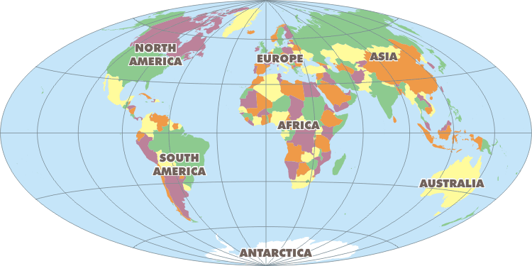
This political world map shows countries as discrete units defined by official borders, illustrating political formal regions. Each color represents a sovereign state, emphasizing uniform governance within boundaries. The map includes more countries than students must memorize, but effectively demonstrates how political decisions create formal regions. Source.
How Formal Regions Are Identified
Geographers identify formal regions through systematic data collection, classification, and mapping. Because formal regions depend on quantifiable characteristics, they are closely tied to geographic data sources.
Steps in Identifying a Formal Region
Determine the defining characteristic, such as climate, language, or political boundary.
Collect consistent data from sources like censuses, climate databases, or governmental records.
Measure and map the distribution of the characteristic across space.
Establish boundaries where the characteristic remains dominant or uniform.
Evaluate internal homogeneity to ensure the area functions as a formal region.
Normal sentence here to separate content from nearby definition blocks.
Homogeneity: The degree to which a region’s defining characteristic is consistently present throughout its spatial extent.
Importance of Formal Regions in Geographic Analysis
Formal regions allow geographers to interpret spatial patterns and understand broad processes across consistent landscapes. They support:
Comparative analysis, enabling students and researchers to examine differences in climate, culture, or governance across regions.
Spatial generalization, which simplifies complex geographic realities into understandable patterns.
Mapping and visualization, since formal regions often appear as clearly defined areas on thematic maps.
Policy-making and planning, especially when governments use formal regional classifications for environmental management, demographic planning, and resource distribution.
Cultural and historical interpretation, illustrating how shared traits influence regional identity and cohesion.
Formal regions remain a foundational geographical concept because they provide clarity and structure in the study of Earth’s diverse physical and human environments.
Practice Questions
Question 1 (1–3 marks)
Explain what is meant by a formal region in geography and provide one example.
Question 1
1 mark for identifying that a formal region is defined by measurable or uniform characteristics.
1 mark for explaining that these characteristics are consistent across the region.
1 mark for providing a valid example (e.g., the Sahel climate zone, the French-speaking region of Quebec, the state of California).
Question 2 (4–6 marks)
Using your knowledge of formal regions, analyse how one physical and one cultural characteristic can each be used to define formal regions at different scales.
Question 2
1 mark for identifying a physical characteristic used to define a formal region (e.g., climate zone or biome).
1 mark for explaining how that physical characteristic creates measurable uniformity across space.
1 mark for identifying a cultural characteristic used to define a formal region (e.g., dominant language or religion).
1 mark for explaining how that cultural characteristic provides internal consistency for the region.
1 mark for referring to variation in scale, such as local, national, or global examples.
1 mark for clear analysis demonstrating how these characteristics affect the delineation and understanding of regions.
FAQ
Geographers prioritise characteristics that are measurable, consistently distributed, and relevant to the research question. For example, a climate researcher may select temperature ranges, whereas a cultural geographer may prioritise language distribution.
They also consider the scale of analysis, since some characteristics—such as religion or political boundaries—may be more meaningful at regional or national scales than at global ones.
Field data, census records, satellite imagery, and linguistic surveys often guide the choice of characteristic.
Yes. A single location can simultaneously fall within overlapping formal regions because each region is defined by a separate measurable trait.
For example:
A city might be part of a Mediterranean climate zone (physical formal region).
At the same time, it might lie within a country such as Spain (political formal region).
It may also belong to a predominantly Spanish-speaking area (cultural formal region).
These overlapping classifications allow geographers to analyse complex spatial identities.
Different organisations may use varying criteria thresholds when defining a region. For example, climate regions may be drawn using different temperature datasets or classification systems.
Methodological choices also affect boundary placement:
Decade of data used
Minimum dominance required for a cultural trait
Political or administrative updates
Thus, boundaries reflect interpretive decisions based on the data and purpose of analysis.
Formal regions create a baseline for comparing how a measurable characteristic shifts over time. By mapping the same region using historical and current data, geographers can identify trends such as climate shifts, demographic transitions, or political restructuring.
This longitudinal comparison is especially useful when:
Monitoring desertification within climate zones
Tracking language loss or expansion
Analysing redrawn political boundaries due to conflict or governance changes
Formal regions rely strictly on measurable uniformity, making them ideal for statistical analysis and mapping consistency.
In contrast:
Functional regions are based on movement and interactions, which may change rapidly.
Perceptual regions depend on shared cultural identity, which varies between groups and lacks strict boundaries.
Because of their clarity and stability, formal regions are often used when researchers need reliable units for comparing spatial patterns or conducting regional-scale modelling.
