
AP Syllabus focus:
‘Functional regions organize around a focal point and interactions; perceptual (vernacular) regions reflect people’s shared ideas and identities.’
Functional and perceptual regions illustrate how people organize and interpret space, revealing patterns of interaction, identity, and shared meaning that shape geographic understanding and human behavior.
Understanding Regional Concepts in Human Geography
The Role of Regions in Spatial Analysis
Geographers use regions to simplify Earth’s complexity by grouping places with shared characteristics or relationships. Within regional analysis, functional regions and perceptual regions are two essential types that emphasize interaction and cultural understanding rather than uniform physical traits. These concepts help explain why some areas operate as connected systems while others exist mainly in people’s minds.
Functional Regions: Organized Around Interaction and a Focal Point
Functional regions are geographic areas defined by patterns of activity, movement, or interaction that radiate from a central hub.
Functional Region: A region organized around a central node where interactions are strongest at the core and weaken with distance.
Normal sentence here to comply with spacing rules between definition blocks.
Characteristics of Functional Regions
A central node—the core location where interactions originate and are most intense.
Connected hinterlands—the surrounding areas linked to the central node by transportation routes, commuting flows, trade, or communication.
Measurable boundaries—often identified using data such as commuting patterns, service areas, or traffic flows.
Distance decay patterns—interactions decrease as distance from the node increases, weakening the region’s functional coherence.
Types of Functional Regions
Economic Functional Regions
These form around economic activity and market influence.
Metropolitan areas centered on a city and its commuting zone.
Trade areas served by major retail centers or logistics hubs.
Agricultural supply chains connecting farms to processing centers.
Political and Administrative Functional Regions
These arise from governance and organizational structures.
School districts where students attend designated institutions linked to administrative control.
Postal delivery zones determined by routinized service distribution.
Public utility service areas defining infrastructure coverage.
Transportation and Communication Functional Regions
These highlight connections created by movement and information.
Airline hub networks organized around major airports.
Broadcast regions based on radio or television signal reach.
Public transit service regions shaped by bus, rail, or subway networks.
In everyday life, a metropolitan area functions as a region because people live in suburbs but commute into the city center for work, shopping, and entertainment.
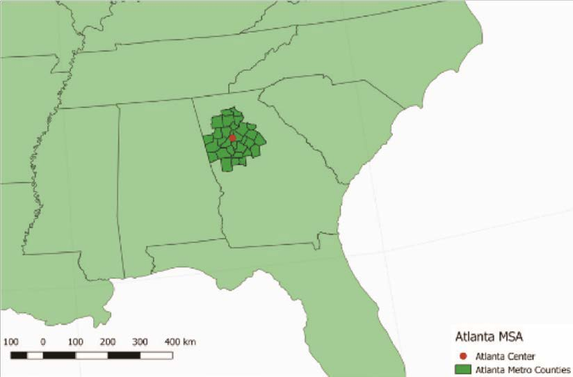
This map shows the Atlanta Metropolitan Statistical Area, a functional region centered on the city of Atlanta. Counties are grouped together because of strong commuting links and shared economic activity rather than uniform culture or physical geography. Students can use this example to visualize how flows of people and jobs create a nodal region around a core city. Source.
Perceptual (Vernacular) Regions: Shaped by Shared Ideas and Identities
Perceptual regions differ fundamentally from functional regions because they are formed through collective cultural understanding rather than measurable interactions.
Perceptual (Vernacular) Region: A region defined by people’s shared attitudes, beliefs, and cultural identity rather than by objective data or formal boundaries.
Normal sentence here to comply with spacing rules between definition blocks.
Characteristics of Perceptual Regions
Subjective boundaries—people disagree about exact borders because they are based on perception, not measurable criteria.
Cultural meaning—identity, symbolism, and tradition shape how the region is understood.
Dynamic definitions—perceptual regions evolve over time as cultures change or new narratives emerge.
Place-based stereotypes or associations—ideas about lifestyle, climate, values, or heritage influence the region’s meaning.
Formation of Perceptual Regions
Perceptual regions emerge through shared cultural processes, including:
Historical narratives—events and cultural memory linking people to an area.
Media representation—films, music, advertising, and news shaping how outsiders perceive the region.
Local identity and pride—how residents conceptualize their own region.
Symbolic landscapes—architecture, accents, cuisine, and cultural markers reinforcing regional meaning.
Why Perceptual Regions Matter in Human Geography
Understanding perceptual regions helps geographers analyze:
Cultural identity and belonging—how people define “home” or see others as outsiders.
Regional stereotypes that influence migration, politics, or social interaction.
Place branding and tourism, which rely on constructed regional imagery.
Spatial behavior shaped by perception, such as where people choose to live, travel, or invest.
A classic AP Human Geography example is “the South” in the United States, whose boundaries shift depending on who is drawing the map and what features they emphasize.
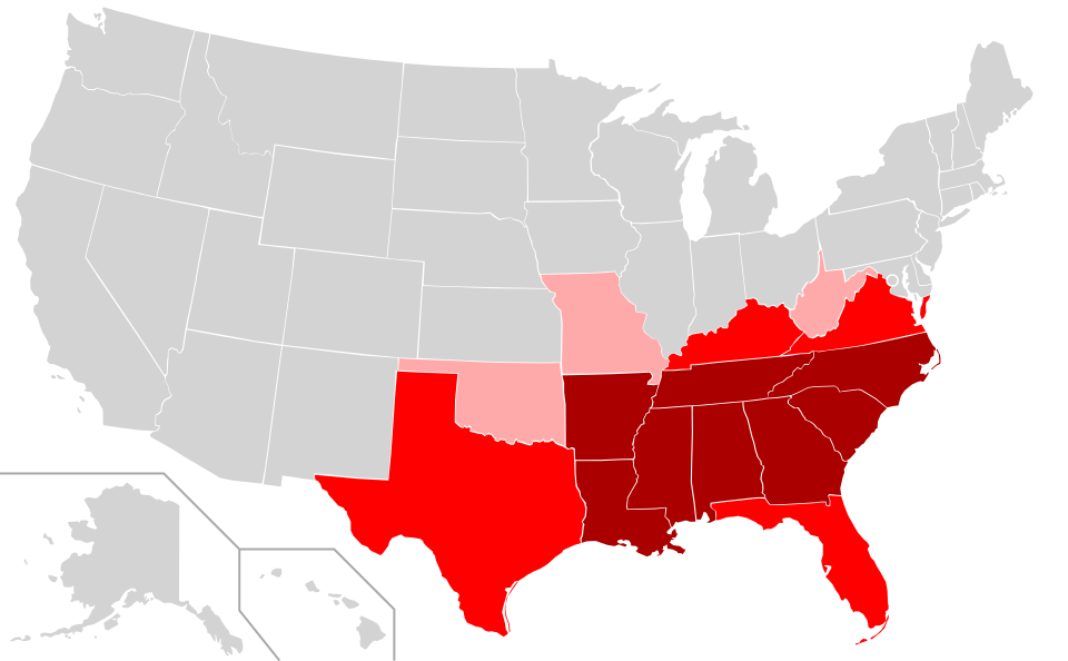
This map illustrates the Southern United States as a perceptual region with multiple possible boundaries. States are shaded to show where people most strongly or weakly agree that an area belongs to “the South.” The variation demonstrates how perceptual regions depend on cultural agreement rather than official political borders. Source.
Comparing Functional and Perceptual Regions
Key Differences
Basis of definition:
Functional regions rely on measurable flows and interactions.
Perceptual regions rely on shared ideas and cultural meaning.
Boundary clarity:
Functional region boundaries can be mapped with data.
Perceptual region boundaries vary depending on perspective.
Purpose:
Functional regions explain how systems operate across space.
Perceptual regions explain how people interpret and experience space.
Why Both Types Are Crucial
Together, functional and perceptual regions help geographers understand not just how places are connected, but also how people imagine, categorize, and make sense of the world.
Practice Questions
Question 1 (1–3 marks)
Explain the difference between a functional region and a perceptual (vernacular) region.
Question 1
1 mark for identifying that a functional region is organised around a central node or focal point.
1 mark for stating that a perceptual region is defined by people’s ideas, beliefs, or cultural identity.
1 mark for clearly contrasting the two (for example, functional regions are based on measurable interactions, whereas perceptual regions have subjective boundaries).
Question 2 (4–6 marks)
Using an example for each, analyse how functional regions and perceptual regions influence how people understand and interact with space.
Question 2
1 mark for describing how functional regions operate through flows or interactions (e.g., commuting, trade, transport links).
1 mark for giving a valid example of a functional region (e.g., a metropolitan area centred on a city).
1 mark for explaining how such a region shapes spatial behaviour (e.g., travel patterns, economic activity).
1 mark for describing how perceptual regions are formed based on shared cultural ideas or identities.
1 mark for giving a valid example of a perceptual region (e.g., “the South” in the United States).
1 mark for analysing how perceptual regions influence people’s understanding or behaviour (e.g., identity, stereotypes, place attachment).
FAQ
Geographers commonly use quantitative datasets to detect how strongly places are connected to a central node. These data help identify where interaction intensity declines enough to form a boundary.
Useful datasets include:
Commuting flows and journey-to-work data
Retail or service catchment areas
Public transport usage patterns
Communication or delivery network routes
Software such as GIS allows these flows to be mapped visually, highlighting clusters and gradients of interaction that shape functional region boundaries.
Perceptual regions are reinforced by long-standing cultural narratives that are difficult to erase, even when measurable conditions shift.
They persist because:
Cultural identities are passed down through generations
Media, literature, and education repeat shared regional imagery
Residents may actively preserve traditions that define their region
External groups—tourists, policymakers, businesses—reinforce recognisable labels
Thus, perceptual regions endure due to cultural momentum rather than physical or economic factors.
Yes. Perceptual regions overlap frequently because they rely on subjective interpretation rather than agreed boundaries.
A single location may be perceived differently depending on cultural background, media exposure, or personal experience. For example:
A city could be viewed as part of a historic cultural region while also belonging to a newer identity shaped by migration.
Border areas often experience blended or transitional identities.
This multi-layered belonging highlights the fluidity of perceptual regions.
Politicians often appeal to perceptual regions because they tap into shared identities and values that influence voter behaviour.
Strategies include:
Associating themselves with regional symbols, accents, or traditions
Tailoring messages to align with perceived cultural attitudes
Using regional labels in policy proposals to build emotional resonance
Framing issues in ways that reinforce or reshape regional identity
These uses show how perceptual regions function as powerful cultural tools in political communication.
Functional regions shift as patterns of interaction evolve. Changes may be gradual or rapid depending on economic and infrastructural developments.
Key drivers include:
Growth or decline of major employers
Construction of new transport networks
Expansion of suburbs or new urban centres
Shifts in retail behaviour, such as the rise of online shopping
Changes in communication systems
As flows of people, goods, and information realign, the spatial footprint of functional regions adjusts accordingly.
