
Edexcel Specification focus:
‘Governance (local and national) and geographical factors such as population density, isolation/accessibility, and degree of urbanisation influence vulnerability and resilience.’
Tectonic disasters don’t impact all communities equally. Governance and geographical factors shape how vulnerable or resilient populations are when hazards like earthquakes or tsunamis strike.
Governance and Vulnerability
What Is Governance?
Governance: The way in which a country or region is managed at different levels, including how laws are enforced, policies are implemented, and resources are distributed.
Governance plays a critical role in determining how effectively a population can prepare for, respond to, and recover from tectonic hazards. It operates on local, regional, and national levels and influences every stage of the hazard management cycle (preparedness, response, recovery, mitigation).
How Governance Influences Vulnerability
Effective governance can significantly reduce risk by:
Enforcing building codes that ensure structures are earthquake-resistant.
Funding and implementing early warning systems for earthquakes, volcanic eruptions, and tsunamis.
Conducting public education and awareness campaigns on emergency procedures.
Coordinating emergency response teams and drills.
Allocating resources for infrastructure maintenance, including roads and hospitals.
Poor governance increases vulnerability by failing in these areas. When public services are underfunded, emergency plans are neglected, and corruption undermines preparedness, communities become more susceptible to hazard impacts.
Governance and Resilience
Resilience: The capacity of a system, community or society to resist, absorb, and recover from the effects of a hazard efficiently.
Governments that invest in disaster risk reduction strategies build resilience. This includes:
Creating contingency plans for different hazard scenarios.
Supporting insurance schemes and compensation programmes.
Promoting community engagement in hazard preparedness.
Developing land-use zoning laws to avoid construction in high-risk areas.
In contrast, the absence of a coherent strategy can lead to long-term socio-economic setbacks.
Geographical Factors and Vulnerability
Population Density
High population density can exacerbate vulnerability because:
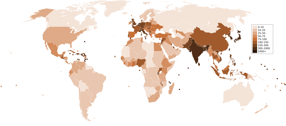
A world choropleth where each country is shaded according to its population density (people per km²), with smaller territories shown as dots; this public-domain map highlights areas where hazard exposure is greatest. Source
More people are exposed to hazards.
Urban areas may experience infrastructure overload, hindering evacuation or rescue.
Informal settlements may emerge on marginal land, such as steep slopes or riverbanks, which are more prone to landslides or liquefaction.
Population Density: The number of people living per unit area, usually measured in persons per square kilometre.
In low-density areas, although fewer people are affected, isolation can hinder emergency response.
Isolation and Accessibility
Isolation refers to physical distance from urban centres and essential services. Geographic isolation can make a community more vulnerable because:
Rescue and relief efforts take longer to arrive.
Communication networks may be weak or disrupted.
Supplies like food, clean water, and medical aid are harder to distribute.
Accessibility depends on transport infrastructure. Poor road quality, rugged terrain, or blocked routes (due to landslides or lava flows) can delay emergency operations.
Populations in mountainous, island, or rural areas are more likely to be isolated. Accessibility is especially critical during the golden 72 hours after a disaster, when survival chances are highest.
Degree of Urbanisation
Urbanisation can both increase and reduce vulnerability:
Increased Vulnerability
Rapid and unregulated urban growth often leads to slums with poor construction standards.
Overcrowding creates bottlenecks during evacuation.
Urban infrastructure may not be hazard-resistant.
Reduced Vulnerability
Well-planned urban areas have better emergency services, communication systems, and infrastructure.
Resources like hospitals, fire services, and shelters are more readily available.
Urban centres are more likely to benefit from investment in risk-reduction technologies.
Urbanisation: The increase in the proportion of people living in towns and cities relative to rural areas.
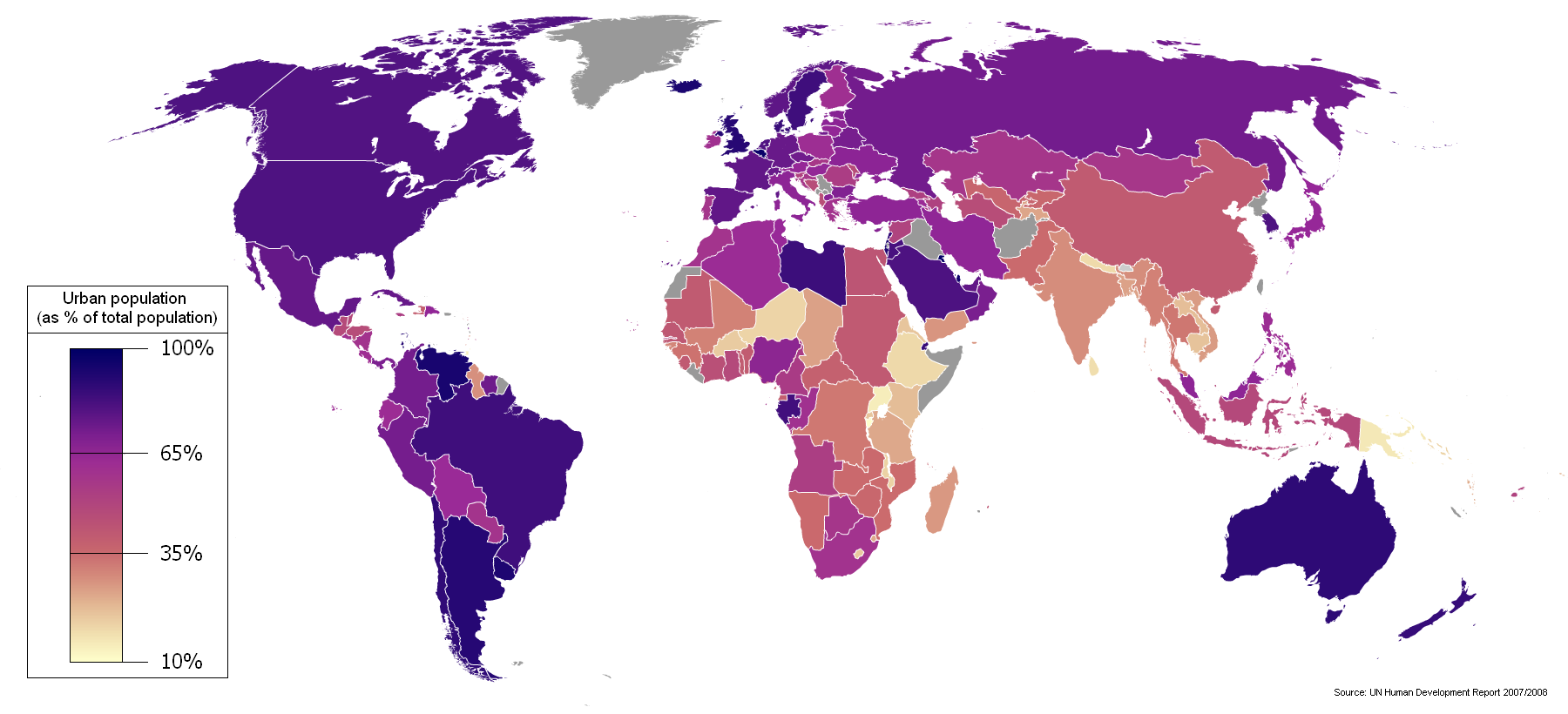
Caption: A 2005 world map shaded by the share of citizens in urban environments (cities ≥200,000 inhabitants), demonstrating how urbanisation clusters in different regions.
Resilience is often stronger in urban environments where governance is more visible and logistical support is better coordinated—provided that planning is effective.Source
Interactions Between Governance and Geography
Governance and geographical factors do not act in isolation. Their interactions create complex risk profiles:
A well-governed but isolated area may still face delays in aid delivery.
Poorly governed urban areas may suffer disproportionately due to high population density and inadequate planning.
Effective governance can mitigate some geographical disadvantages, such as through improved road networks, communication systems, and decentralised disaster planning.
Bullet Summary: Key Factors Affecting Vulnerability and Resilience
Governance
Strength of legal frameworks
Effectiveness of emergency services
Public awareness and education
Resource allocation and planning
Geographical Factors
Population density
Isolation and transport access
Level and quality of urbanisation
Practice Questions
Question 1 (3 marks)
Define the term governance and explain one way it can influence a population’s vulnerability to tectonic hazards.
Mark Scheme
Question 1 (3 marks)
1 mark for a correct definition of governance:
Governance is the way in which a country or region is managed, including laws, policies, and resource distribution.1 mark for identifying one way it influences vulnerability (e.g. enforcement of building codes, early warning systems, emergency planning).
1 mark for explaining how this reduces or increases vulnerability (e.g. Enforcing building codes ensures homes are more resistant to earthquakes, reducing collapse risk).
Question 2 (6 marks)
Explain how geographical factors such as population density and accessibility can affect the impact of tectonic hazards on communities. Use examples to support your answer.
Question 2 (6 marks)
Level 1 (1–2 marks):
Basic description of population density or accessibility without clear linkage to impact.
Limited or no examples.
Level 2 (3–4 marks):
Some explanation of how both factors influence hazard impact.
May include generalised or single examples.
Some use of terminology (e.g. ‘isolation’, ‘urban infrastructure’).
Level 3 (5–6 marks):
Clear explanation of how population density increases exposure and how poor accessibility delays emergency response.
Appropriate use of examples (e.g. densely populated cities in LICs, remote island communities).
Well-structured answer with sound geographical understanding.
FAQ
Decentralised governance, where local authorities have more control over disaster planning and resource allocation, can improve disaster response by allowing quicker, context-specific action.
Local governments often have better knowledge of community vulnerabilities, geography, and infrastructure. This can lead to more efficient evacuation plans, faster distribution of aid, and stronger community engagement.
However, success depends on the capacity and funding available at the local level. In some cases, decentralisation without proper support can lead to uneven preparedness across regions.
Urban slums are typically built in hazard-prone areas, such as unstable hillsides or floodplains, due to lack of affordable housing elsewhere.
Their vulnerability is heightened by:
Poor construction quality with no adherence to building codes.
High population density, increasing risk of injury and difficulty evacuating.
Limited access to emergency services and infrastructure like roads and hospitals.
Governance often overlooks these informal settlements, leading to poor risk communication and inadequate mitigation measures.
Yes, effective governance can help offset the risks posed by challenging geographical conditions.
Examples include:
Building resilient infrastructure in isolated or mountainous areas.
Investing in transport networks to improve accessibility.
Creating decentralised emergency supply hubs in remote regions.
Enforcing strict land-use zoning to avoid high-risk zones.
However, mitigation depends on sustained investment, political stability, and coordination across government levels.
In areas with weak formal governance, informal community leadership can play a crucial role in hazard preparedness and response.
Examples of contributions include:
Organising evacuation drills and first-aid training.
Sharing local knowledge about past hazards and safe zones.
Coordinating mutual aid during recovery phases.
While these networks are valuable, their effectiveness is limited without external support, funding, or integration with official emergency plans.
Governments rely on accurate, up-to-date data to plan effective hazard responses and resilience strategies.
Key uses of data include:
Mapping vulnerable populations and high-risk areas.
Tracking infrastructure weaknesses.
Monitoring hazard frequency and magnitude over time.
In low-income or poorly governed regions, lack of data can lead to poor decision-making, underfunded mitigation strategies, and reactive rather than proactive policies. Investing in hazard mapping and data collection strengthens both planning and accountability.
