
Edexcel Specification focus:
‘Contrasting tectonic hazard events in developed, emerging and developing countries show how physical and human factors interact and how location influences disaster scale.’
Tectonic disasters vary widely across the world. Differences in development, governance, population density and geography influence how severe and damaging these events become.
Understanding Contrasting Case Studies
To understand the diverse impacts of tectonic hazards, it is essential to compare events from countries at different levels of development: developed, emerging, and developing. This approach highlights the interaction between physical processes and human factors, demonstrating how location and socioeconomic context can significantly influence the scale of disaster.
Developed Countries: High Capacity, High Exposure
Example Characteristics
Well-developed infrastructure
High investment in hazard mitigation
Strong governance and emergency response
High-value assets and dense urban populations
Despite having robust systems in place, developed countries often face high economic losses due to their concentrated assets and advanced infrastructure. However, mortality rates tend to be lower due to effective planning and healthcare systems.
Developed Country: A nation with a high level of industrialisation, high GDP per capita, and well-established infrastructure and services.
Interacting Factors
Physical exposure: Located on active margins (e.g. Japan on a subduction zone).
Urban density: High population concentration in megacities increases exposure.
High-tech monitoring and building codes reduce vulnerability.
Strong governance structures coordinate swift emergency response and long-term recovery.
Emerging Countries: Increasing Risk with Rapid Growth
Example Characteristics
Rapid economic development
Expanding urban populations
Partial infrastructure development
Growing but uneven disaster response systems
Emerging economies often struggle with the pace of urbanisation, where infrastructure cannot always keep up with growth. This increases the vulnerability of populations living in informal settlements or poorly regulated areas.
Emerging Country: A nation experiencing rapid economic growth and development, transitioning from a developing to developed status.
Interacting Factors
Inadequate planning: Informal settlements often built in high-risk zones.
Variable governance: National response may be strong, but local coordination can be inconsistent.
Physical factors: Hazards may occur near tectonic boundaries, but secondary hazards like landslides and flooding compound impacts.
Economic disruption: Damage to infrastructure can stall economic growth.
Developing Countries: High Vulnerability, Limited Capacity
Example Characteristics
Low GDP and limited public resources
Poorly constructed buildings and infrastructure
Inadequate emergency services
High reliance on international aid
In developing countries, even moderate tectonic events can result in catastrophic human impacts due to low resilience and lack of preparedness. Vulnerable groups, such as the urban poor, are disproportionately affected.
Developing Country: A nation with low levels of income, education, and infrastructure development, often reliant on subsistence farming and international assistance.
Interacting Factors
Poor housing: Unreinforced structures collapse easily during earthquakes.
Limited education: Lack of awareness about evacuation procedures or hazard signs.
Weak governance: Delayed and disorganised response prolongs suffering.
Geographic isolation: Mountainous or remote regions slow the delivery of aid.
Human and Physical Factors That Interact
Physical Factors
Magnitude of event: Larger magnitude = greater potential impact.
Focal depth and proximity to population: Shallow earthquakes near urban centres are more destructive.
Tectonic setting: Convergent boundaries and subduction zones often generate the most powerful hazards.
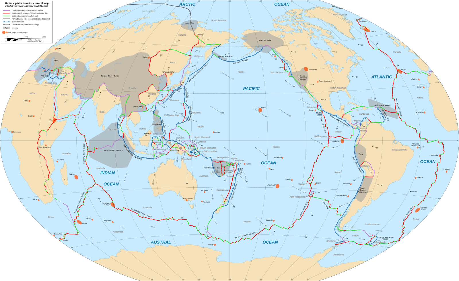
A world map of Earth’s principal tectonic plates and their boundaries, showing the convergent margins where subduction generates the largest earthquakes and tsunamis. Source
Secondary hazards: Landslides, tsunamis and aftershocks worsen impacts.
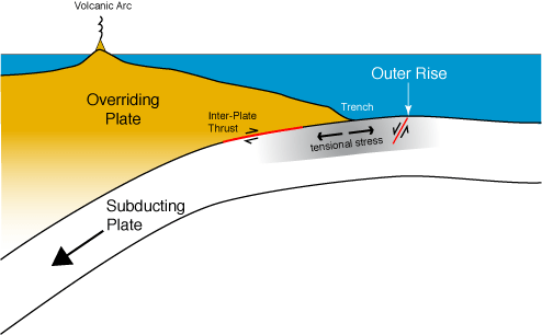
A schematic diagram of a subduction zone showing the trench, accretionary wedge and down‑going plate where megathrust earthquakes and tsunamis originate. Source
Human Factors
Development level: Determines infrastructure quality and medical care access.
Governance: Strong political institutions enable quicker, more organised responses.
Urban planning: Enforced zoning and building regulations reduce fatalities.
Population density: High density increases casualties and complicates evacuations.
Education and preparedness: Community awareness can reduce vulnerability.
The Role of Location in Disaster Scale
A country’s geographic context also contributes significantly to the impact of a tectonic hazard.
Island nations (e.g. Indonesia) may face tsunamis without sufficient warning or escape routes.
Mountainous regions (e.g. Nepal) are prone to landslides, complicating rescue efforts.
Low-income urban areas often lie on marginal land (e.g. floodplains or steep slopes) due to affordability, increasing their risk.
Disaster Scale: The overall magnitude of a disaster’s impact, considering human, economic, and environmental effects.
Case Study Contrasts: Synthesising Impacts
Developed Example – Japan (2011 Tōhoku Earthquake and Tsunami)
9.0 magnitude undersea quake triggered massive tsunami.
20,000+ deaths, but rapid response and tsunami warning systems reduced further losses.
Economic cost: over $200 billion – high due to nuclear and infrastructure damage.
High resilience and recovery capacity.
Emerging Example – Chile (2010 Maule Earthquake)
8.8 magnitude quake, significant infrastructure damage.
500+ deaths, partly due to delayed tsunami warning.
Effective governance enabled quick rebuilding of roads and hospitals.
Developing Example – Haiti (2010 Earthquake)
7.0 magnitude quake near capital, Port-au-Prince.
Over 220,000 deaths, largely due to poor construction and lack of preparedness.
Massive reliance on international aid, prolonged recovery.
These examples show how similar tectonic processes can yield vastly different outcomes based on economic development, governance quality, and location. By comparing case studies across these three contexts, students can understand the complex interplay of factors that determine the scale and severity of tectonic disasters.
Practice Questions
Question 1 (3 marks)
Define what is meant by a "developing country" and explain one reason why such countries may experience greater social impacts from tectonic hazards than developed countries.
Mark Scheme:
1 mark for an accurate definition:
Developing Country: A nation with low levels of income, education, and infrastructure development, often reliant on subsistence farming and international assistance.1 mark for identifying a valid reason (e.g. poor housing, limited emergency response, weak governance).
1 mark for explaining how this reason increases social impact (e.g. buildings collapse more easily, causing higher death tolls).
Question 2 (6 marks)
Using contrasting case studies, explain how physical and human factors interact to influence the scale of disaster caused by tectonic hazards.
Mark Scheme:
Up to 3 marks for clear and accurate explanation of physical factors (e.g. magnitude, depth, proximity to population, tectonic setting, presence of secondary hazards).
Up to 3 marks for explanation of human factors (e.g. development level, governance, population density, preparedness, infrastructure).
For full marks:
At least one contrasting example must be referenced (e.g. Japan vs. Haiti).
Interaction must be explained, e.g. A shallow, high-magnitude earthquake near a densely populated but well-prepared city like Tokyo causes less loss of life than a smaller quake in a poorly prepared city like Port-au-Prince.
Answers with only physical or only human factors capped at 4 marks.
Basic, generic responses capped at 3 marks.
FAQ
Building design plays a critical role in disaster resilience. In developed countries, strict building codes ensure that structures are reinforced to withstand ground shaking and lateral movement, reducing the risk of collapse.
In contrast, many developing countries have informal housing made of unreinforced materials like mud brick or poorly constructed concrete, which are highly vulnerable to seismic forces.
Key features of earthquake-resistant buildings include:
Deep foundations or base isolators
Reinforced steel or cross-bracing
Flexible materials that absorb shock
Weak construction standards often lead to high death tolls even during moderate seismic events.
The variation in tsunami impacts is influenced by both preparedness and response capability.
Developed countries often have:
Advanced tsunami warning systems
Evacuation drills and public education
Coastal defences like sea walls and buffer zones
In developing countries:
Warnings may not reach remote or rural populations
Limited transport infrastructure delays evacuation
Emergency services are under-resourced and slow to respond
As a result, although the physical hazard may be similar, the outcomes are more severe in areas with lower capacity to anticipate and manage tsunami risk.
International aid provides critical short- and long-term support, especially in countries lacking resources for effective response.
Short-term aid includes:
Medical teams and supplies
Search and rescue operations
Food, water, and shelter
Long-term aid can help:
Rebuild infrastructure
Improve governance and planning
Fund hazard-resilient development
However, aid can sometimes be misallocated, delayed, or create dependency. Success depends on coordination with local governments and community involvement in recovery efforts.
High population density increases the number of people at risk, particularly in urban areas located near tectonic hazards.
In dense cities:
More people are exposed to collapsing infrastructure
Emergency services can be overwhelmed
Evacuation is slower due to congestion and limited routes
Informal settlements within dense areas are particularly at risk due to poor construction, lack of zoning enforcement, and minimal public awareness. These areas often suffer the highest mortality and injury rates during tectonic events.
Governance determines how effectively a country can plan for, respond to, and recover from tectonic hazards.
Good governance enables:
Investment in early warning systems and resilient infrastructure
Clear emergency plans and trained personnel
Transparent coordination with aid agencies
Poor governance may result in:
Corruption or misuse of aid funds
Delayed emergency response
Failure to enforce building codes
Governance is often the key human factor that influences whether a tectonic hazard becomes a large-scale disaster.
