
Edexcel Specification focus:
‘Multiple-hazard zones where tectonic and hydro-meteorological hazards combine, such as in the Philippines.’
A multiple-hazard zone is highly exposed to overlapping natural hazards, increasing vulnerability, disaster risk and response complexity for populations and governments alike.
Understanding Multiple-Hazard Zones
Multiple-hazard zones are regions where two or more types of natural hazards—particularly tectonic and hydro-meteorological—occur in close proximity or simultaneously. These zones face an elevated disaster risk, as the interaction between different hazards can produce cascading impacts, amplify damage, and overwhelm response mechanisms.
Multiple-hazard zone: A region where several types of natural hazards (e.g. earthquakes, tsunamis, volcanic eruptions, tropical storms, floods, landslides) overlap spatially and/or temporally, increasing risk.
Populations in these areas often face significant challenges in terms of preparedness, resilience, and long-term recovery, as the range and severity of hazards can change quickly and unexpectedly.
Multiple-hazard zones are places where two or more natural hazards occur, and in some cases interact to produce complex disasters.
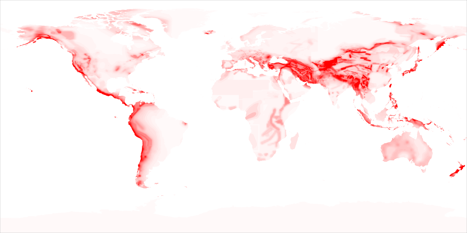
This map displays global seismic hazard levels (peak ground acceleration) based on historical earthquake data and modeling. It highlights regions of high tectonic risk but does not show hydro‑meteorological hazards or focus on the Philippines specifically. Source
Tectonic Hazards in Multiple-Hazard Zones
Many multiple-hazard zones lie along or near tectonic plate boundaries, where plate interactions give rise to:
Earthquakes, resulting from sudden releases of stress along faults.
Volcanic eruptions, occurring where magma rises through weaknesses in the Earth’s crust.
Tsunamis, generated by undersea earthquakes, volcanic activity or landslides that displace large volumes of seawater.
These tectonic hazards often have short warning times, making them difficult to predict and plan for. Their impacts can destabilise landscapes, destroy infrastructure and displace communities.
Hydro-Meteorological Hazards in Multiple-Hazard Zones
Hydro-meteorological hazards include:
Tropical cyclones (typhoons or hurricanes), bringing intense rainfall, flooding and wind damage.
Monsoons, which cause prolonged periods of heavy rain.
Floods and landslides, often resulting from storm rainfall or saturated soils on steep slopes.
Droughts, reducing access to clean water and damaging agriculture.
These hazards are strongly influenced by climate variability and seasonal patterns, and can occur regularly or cyclically in vulnerable regions.
Why Hazard Interaction Matters
In multiple-hazard zones, tectonic and hydro-meteorological hazards do not occur in isolation. Their interaction can magnify impacts:
Typhoons followed by volcanic eruptions can trigger deadly lahars (volcanic mudflows).
Earthquakes may weaken slopes, increasing the likelihood of rain-induced landslides.
A tsunami following a subduction zone earthquake may strike areas already weakened by previous flooding or storms.
These compound effects place greater stress on emergency services, housing, infrastructure and governance systems.
Case Study Focus: The Philippines
The Philippines is a prominent example of a multiple-hazard zone.
Tectonic Setting
Located on the Philippine Plate, part of the Pacific Ring of Fire.
Frequent earthquakes and volcanic eruptions due to active convergent plate boundaries.
Presence of many active volcanoes, such as Mount Mayon and Taal Volcano.
Hydro-Meteorological Setting
Lies within the Western Pacific typhoon belt.
Struck by 20+ typhoons annually, with around 5–7 classified as destructive.
Experiences seasonal monsoons, heavy rainfall and flooding.
Prone to landslides, particularly in mountainous regions with steep terrain.
Hazard Interactions
Typhoon-induced rainfall can mobilise volcanic ash deposits into lahars.
Heavy rainfall from the typhoon mobilised volcanic ash into destructive lahars.
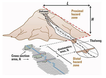
This USGS diagram shows an idealized lahar cross-section (A) and plan view (B), demonstrating how volcanic debris and water mix to inundate valleys. It models the relationship between vertical drop (H) and inundation area, aiding prediction of lahar extents. It is a generic tool and not specific to the June 1991 Pinatubo event. source
Seismic activity weakens slopes, increasing landslide risk during storms.
Coastal communities face tsunami threats alongside storm surges.
Social and Economic Vulnerability
High population density, particularly in urban coastal areas such as Manila.
Significant levels of poverty, informal housing and limited access to services.
Disparities in governance capacity and emergency response across regions.
Key Characteristics of Multiple-Hazard Zones
Multiple-hazard zones tend to share the following characteristics:
Geophysical location at plate boundaries and in tropical climate zones.
Exposure to multiple hazards within a short time frame.
Vulnerable populations, including the urban poor, rural isolated groups and coastal dwellers.
Limited infrastructure resilience and emergency response resources.
High potential for compound disasters and cascading impacts.
Implications for Disaster Risk Management
Effective disaster risk reduction (DRR) in multiple-hazard zones requires integrated strategies:
Hazard mapping to identify overlaps and interactions.
Early warning systems that address multiple hazard types.
Land-use planning, especially to avoid building in floodplains or on unstable slopes.
Community-based preparedness, education and evacuation planning.
Investment in infrastructure that can withstand various hazard types (e.g. earthquake- and typhoon-resistant buildings).
Cascading hazard: A situation where one hazard triggers a secondary event, which in turn leads to further hazards, increasing overall disaster severity.
Governments, NGOs and international partners must work collaboratively to strengthen resilience, reduce exposure, and support long-term adaptation in these high-risk environments. Strategic planning and risk-informed development are essential to reduce the impact of disasters in the future.
Practice Questions
Question 1 (3 marks):
Define the term multiple-hazard zone and explain why the Philippines is considered an example of one.
Mark Scheme:
1 mark for a correct definition:
Multiple-hazard zone: A region where several types of natural hazards (e.g. earthquakes, tsunamis, typhoons) occur in close proximity or within a short time frame.1 mark for identifying that the Philippines experiences both tectonic and hydro-meteorological hazards.
1 mark for an example of either a tectonic (e.g. earthquakes, volcanoes) or hydro-meteorological hazard (e.g. typhoons, flooding) in the Philippines.
Question 2 (6 marks):
Explain how interactions between tectonic and hydro-meteorological hazards can increase disaster risk in multiple-hazard zones.
Mark Scheme:
Up to 3 marks for describing how hazards interact:
E.g. rainfall from typhoons can remobilise volcanic ash, causing lahars. (1)
Earthquakes can destabilise slopes, making landslides more likely during heavy rainfall. (1)
A tsunami may strike a coastline already weakened by a tropical storm. (1)
Up to 3 marks for explaining the increased disaster risk:
Hazard interactions can compound impacts, causing more widespread or severe damage. (1)
Emergency services may be overwhelmed by simultaneous or sequential hazards. (1)
Populations may not recover fully from one hazard before another occurs, reducing resilience. (1)
Answers should demonstrate clear understanding of hazard interaction and link these processes to increased risk or vulnerability. Full marks require both explanation and examples.
FAQ
Countries located at the intersection of major tectonic plate boundaries and in tropical climate zones are most prone. These locations combine high tectonic activity (earthquakes, volcanoes) with frequent hydro-meteorological hazards (typhoons, monsoons, floods).
Additional risk factors include:
Steep mountainous terrain, increasing landslide susceptibility
Dense populations in hazard-prone areas (e.g. coasts or volcano foothills)
Limited resources or governance capacity to mitigate risks
Geography, climate, and socio-economic factors all contribute to making a country more vulnerable to multiple interacting hazards.
Hazard interaction often creates a cascading effect, where one hazard triggers or worsens the impact of another. This leads to more complex emergencies and more extensive damage than single events.
Examples include:
A typhoon triggering lahars from previous volcanic ash deposits
Earthquakes weakening slopes that later collapse during heavy rain
Infrastructure damaged by one hazard failing during a subsequent event
These compound effects stretch emergency response, reduce warning times, and heighten risk for affected communities.
Scientists use a combination of technologies and fieldwork to monitor hazards and assess risk in multiple-hazard zones. These include:
Seismic networks to detect earthquakes
Remote sensing (e.g. satellite imagery) to track land changes, volcanic activity, and rainfall
Hazard mapping to overlay tectonic and climatic risks
Modelling tools to simulate scenarios like lahars or compound disasters
Data is often shared with disaster management agencies for early warning systems and land-use planning.
Urban development can increase exposure and vulnerability when it occurs in unsafe areas, especially in rapidly growing cities with limited planning.
Risks are heightened by:
Building on unstable slopes or floodplains
Informal settlements lacking strong structures or drainage
Overcrowded conditions reducing evacuation efficiency
Inadequate infrastructure to withstand hazard impacts
Poorly planned urbanisation in hazard-prone regions like coastal Manila or hillside towns in the Philippines can magnify disaster impacts.
Yes. Climate change can intensify hydro-meteorological hazards, increasing the frequency and severity of storms, rainfall events, and droughts.
In multiple-hazard zones:
Warmer oceans may fuel stronger typhoons
Heavier rainfall can worsen flooding and trigger more landslides
Changing rainfall patterns may increase the unpredictability of hazard timing
Though climate change doesn’t cause tectonic hazards, it can intensify the outcomes when combined with tectonic activity.
