
AP Syllabus focus:
‘Identify major terrestrial biomes: taiga, temperate rainforest, temperate seasonal forest, tropical rainforest, shrubland, temperate grassland, savanna, desert, and tundra.’
Terrestrial biomes are large land regions grouped by long-term patterns of temperature and precipitation.
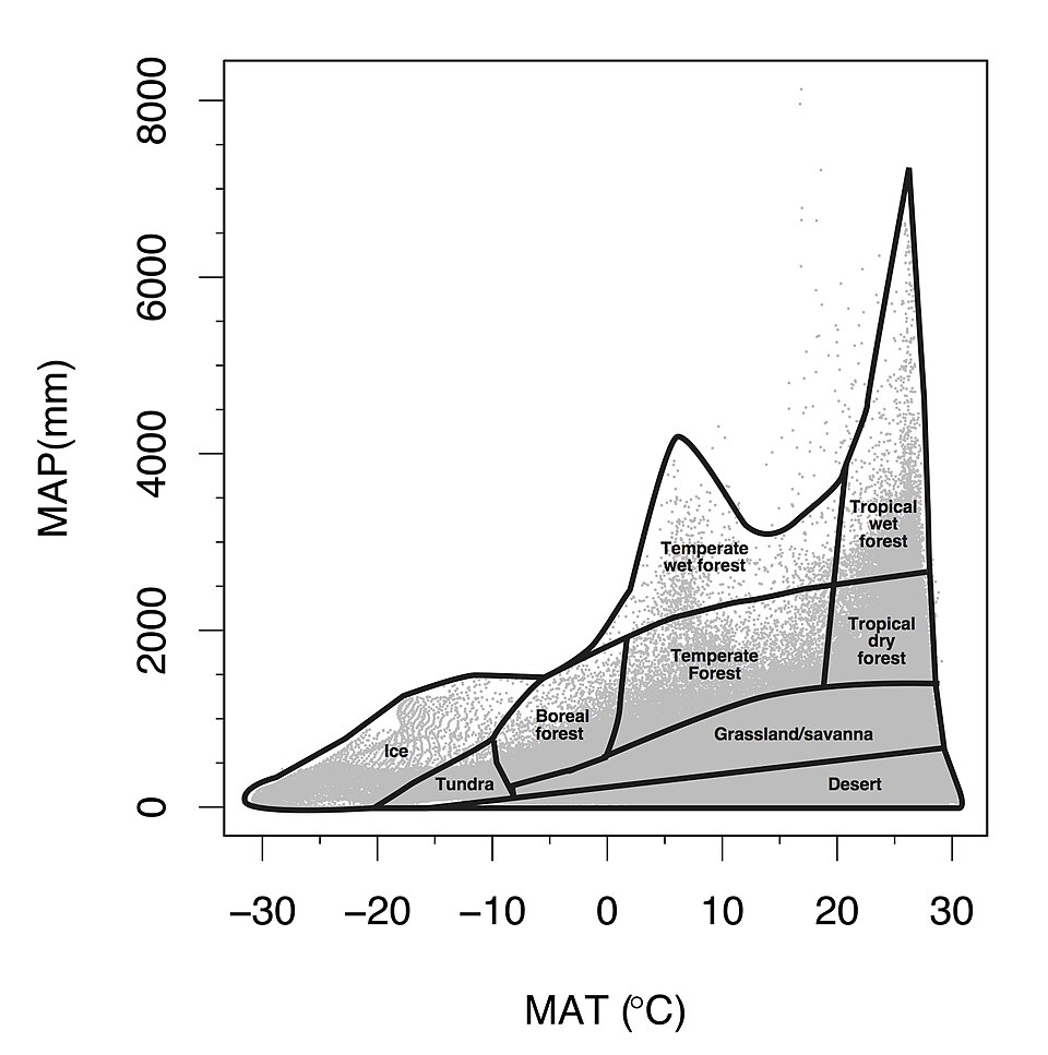
Modified Whittaker biome diagram (temperature vs. precipitation). This plot shows how major terrestrial biomes cluster in “climate space,” with mean annual temperature on one axis and mean annual precipitation on the other. It provides a compact way to predict dominant vegetation and productivity from long-term climate patterns. Source
Knowing each biome’s typical climate, dominant vegetation, and broad geographic distribution helps predict biodiversity, productivity, and human land-use pressures.
Major terrestrial biomes (overview)
Cold biomes
Tundra
Climate: very cold; low precipitation (often as snow); short growing season
Vegetation: low, ground-hugging plants (mosses, lichens, sedges, dwarf shrubs); few/no trees
Where found: high latitudes (Arctic) and high elevations (alpine)
Key constraint: frozen ground limits rooting depth and water infiltration
Permafrost: permanently (multi-year) frozen subsoil that restricts drainage and root penetration.
Limited nutrient cycling and slow decomposition are common because cold temperatures reduce microbial activity.
Taiga (boreal forest)
Climate: long, cold winters; short mild summers; moderate precipitation
Vegetation: coniferous evergreens (spruce, fir, pine) with needle-like leaves that reduce water loss
Where found: Canada, Alaska, Scandinavia, Russia
Typical conditions: acidic, nutrient-poor soils; periodic wildfire and insect outbreaks influence forest structure
Temperate biomes
Temperate rainforest
Climate: mild temperatures; very high precipitation; frequent fog
Vegetation: large evergreen trees (e.g., Douglas fir, redwoods), ferns, mosses; high biomass
Where found: coastal mid-latitudes (Pacific Northwest, southern Chile, New Zealand)
Notable feature: dense canopy and abundant moisture support thick understory and epiphytes
Temperate seasonal forest (deciduous forest)
Climate: warm summers and cold winters; moderate precipitation spread through the year
Vegetation: deciduous trees (oak, maple, beech) that drop leaves to reduce winter water loss and frost damage
Where found: eastern United States, Europe, East Asia
Soils: generally fertile due to leaf litter decomposition and active nutrient cycling in warmer seasons
Shrubland (chaparral)
Climate: hot, dry summers and mild, wet winters
Vegetation: drought-tolerant, woody shrubs with small, waxy leaves; grasses and herbs seasonally
Where found: Mediterranean climates (California, Mediterranean Basin, parts of Chile, South Africa, Australia)
Disturbance regime: frequent fires; many plants resprout or have fire-triggered seed germination
Temperate grassland (prairie/steppe)
Climate: hot summers, cold winters; moderate but variable precipitation
Vegetation: grasses and forbs; few trees due to limited rainfall and fire
Where found: Great Plains, Pampas, Eurasian steppe
Soils: often deep and fertile (high organic matter); historically maintained by grazing and periodic fire
Tropical and subtropical biomes
Tropical rainforest
Climate: warm year-round; very high precipitation
Vegetation: multi-layered canopy of broadleaf evergreens; extremely high species richness
Where found: near the equator (Amazon, Congo Basin, Southeast Asia)
Soils: can be nutrient-poor because nutrients are rapidly taken up and recycled; heavy rainfall can promote leaching
Savanna (tropical grassland)
Climate: warm year-round; distinct wet and dry seasons
Vegetation: grasses with scattered trees (e.g., acacia, baobab); adapted to drought and fire
Where found: East and southern Africa, parts of South America and Australia, India
Ecological drivers: seasonal rainfall, fire, and large herbivores shape tree–grass balance
Dry biomes
Desert
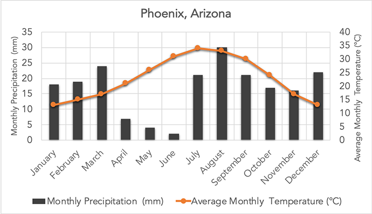
Desert climograph (Phoenix, Arizona). Bars show monthly precipitation and the line shows average monthly temperature, illustrating that deserts have low rainfall even when temperatures are high. The seasonal pattern helps explain why desert organisms are strongly shaped by water limitation rather than temperature alone. Source
Climate: very low precipitation; can be hot (subtropical) or cold (continental/rain shadow)
Vegetation: sparse, drought-adapted plants (succulents, shrubs, ephemeral annuals); wide spacing reduces competition for water
Where found: around 30° latitude (Hadley cell deserts) and rain shadows (leeward of mountains)
Key adaptations: water storage, reduced leaf area, nighttime gas exchange in some plants, burrowing/nocturnal animal behaviour
Practice Questions
Identify two major terrestrial biomes and state one characteristic climate feature for each. (2 marks)
1 mark: correctly names any two of: taiga, temperate rainforest, temperate seasonal forest, tropical rainforest, shrubland, temperate grassland, savanna, desert, tundra.
1 mark: gives an appropriate climate feature for each named biome (e.g., desert: very low precipitation; tundra: very cold/short growing season; tropical rainforest: warm and very wet).
Compare temperate grassland, shrubland, and savanna in terms of (i) precipitation pattern, (ii) dominant vegetation structure, and (iii) the role of fire. (6 marks)
1 mark: temperate grassland has moderate/variable precipitation (often seasonal).
1 mark: shrubland has hot dry summers and mild wet winters (Mediterranean pattern).
1 mark: savanna has distinct wet and dry seasons (tropical seasonal rainfall).
1 mark: vegetation—grassland dominated by grasses/forbs with few trees.
1 mark: vegetation—shrubland dominated by woody shrubs; savanna grasses with scattered trees.
1 mark: fire is important in maintaining grasslands and shrublands; also influences savanna tree–grass balance (any valid description).
FAQ
Rain-shadow deserts develop on the leeward side of mountain ranges where descending air warms and dries after losing moisture on the windward slope.
Typical locations include interior basins and the downwind sides of major ranges (e.g., Andes, Sierra Nevada, Himalayas).
Nutrients are often held in living biomass rather than soil. Rapid decomposition and immediate plant uptake keep nutrients cycling near the surface.
Intense rainfall can leach soluble nutrients downward, reducing long-term soil fertility.
Cold deserts have low precipitation but experience long, cold winters and short growing seasons, with precipitation often as snow.
Hot deserts have higher year-round temperatures and may have brief, intense rainfall events.
Dense grass root systems contribute large amounts of organic matter below ground.
Periodic dieback, grazing, and fire can promote nutrient mixing and the buildup of deep, dark topsoil.
Temperate rainforests are cooler, often coastal, and can be dominated by fewer tree species with very high biomass (large conifers).
Tropical rainforests are warm year-round and typically have much higher species richness and more complex vertical layering.
