
AP Syllabus focus:
‘Spatial concepts include absolute location and relative location, which help explain where something is and how it relates to other places.’
Understanding where something is located is fundamental to geographic inquiry. Absolute and relative location provide essential frameworks for describing spatial positions and explaining how places connect, interact, and develop distinctive geographic meanings.
Absolute Location
Absolute location identifies the precise, fixed position of a place on Earth, most commonly using latitude and longitude, which form the global grid system that enables accurate spatial pinpointing.
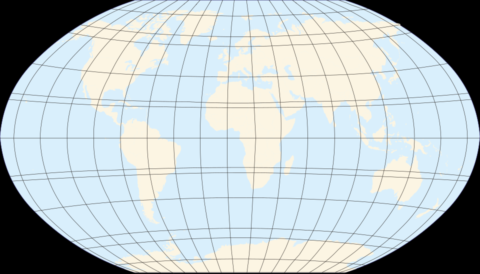
World map with a latitude–longitude graticule showing the global grid used to express absolute location. Each intersection of latitude and longitude corresponds to a unique coordinate on Earth. This reinforces how absolute location relies on a universal reference system rather than local landmarks. Source.
Defining Absolute Location
Absolute Location: The exact, non-changing position of a place on Earth expressed through a coordinate system such as latitude and longitude.
Absolute location is crucial because it supplies a universal reference understood across cultures and technologies. A point at 40° N, 74° W has the same meaning to a geographer, pilot, or GPS device. This consistency supports global navigation, mapping, and scientific observation.
After establishing a precise position, geographers can measure additional characteristics tied to absolute location, such as elevation, physical landforms, and environmental conditions. These attributes help researchers compare places objectively and detect spatial patterns such as climate zones, tectonic boundaries, and population distributions.
Importance of Absolute Location in Geographic Analysis
Absolute location matters because it allows geographers to:
Identify places with scientific precision.
Measure spatial relationships such as distance, direction, and scale.
Locate environmental features and cultural sites on standardized maps.
Support geospatial technologies like GPS, remote sensing, and GIS-based modeling.
Track changes over time, such as shifting coastlines or urban expansion.
Although absolute location provides accuracy, it does not fully explain how places interact or relate to one another. For that, geographers rely on relative location.
Relative Location
Relative location describes where a place is in relation to other places, features, or systems. It is fundamentally contextual and changes depending on cultural, economic, and personal perspectives.
Defining Relative Location
Relative Location: The position of a place described by its connections, accessibility, and relationship to other locations, rather than by fixed coordinates.
Relative location is dynamic because it depends on movement, perceptions, routes, and the spatial organization of human activity.
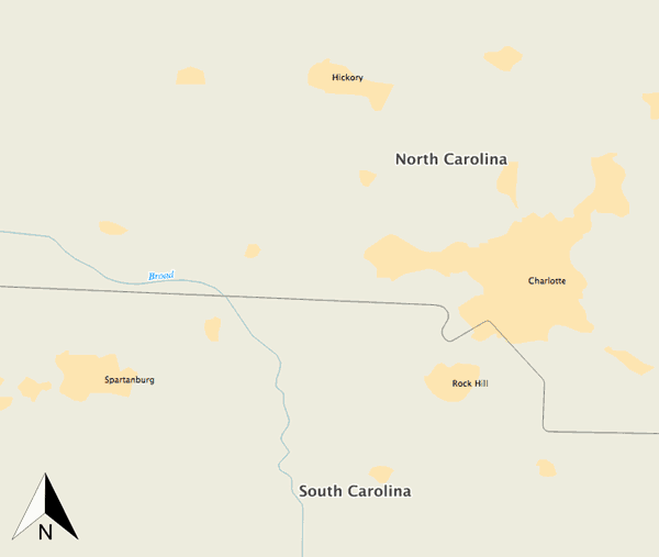
Map illustrating the relative location of the Broad River within North and South Carolina. The river’s position varies depending on reference points such as nearby cities, demonstrating how relative location is framed by direction and proximity. Additional city labels and boundaries provide contextual detail beyond the core syllabus requirement but remain consistent with geographic principles. Source.
For example, saying that a city is “north of Chicago,” “along a major river,” or “two hours by train from Paris” provides relational information that helps explain functional and experiential geography.
Why Relative Location Matters
Relative location helps geographers analyze how spatial relationships shape human behavior. Its value stems from how it conveys connectivity, access, and interaction, which affect economic development, political power, and cultural diffusion. Key applications include:
Explaining why certain cities become trade hubs.
Understanding migration flows and transport networks.
Assessing how proximity influences cultural exchange and conflict.
Evaluating accessibility to resources, markets, and services.
Interpreting perceptions and mental maps shaped by lived experience.
Because relative location is fluid, improvements in technology, infrastructure, or political boundaries can shift a place’s relative importance. A new highway may bring increased interaction, while a closed border may reduce connections and reduce accessibility.
Comparing Absolute and Relative Location
Although both concepts describe where something is, they serve different geographic purposes and reveal different types of spatial meaning. Understanding the distinction helps students grasp how geographers analyze space at multiple scales.
Key Differences
Precision vs. Context: Absolute location provides a fixed coordinate; relative location describes a place in relation to others.
Universality vs. Flexibility: Absolute coordinates are the same for all users; relative descriptions vary based on perspective.
Mapping vs. Interpretation: Absolute location helps construct accurate maps; relative location helps interpret movement, accessibility, and spatial organization.
Stability vs. Change: Absolute location remains constant; relative location changes with transportation systems, economic conditions, and cultural perceptions.
Interdependence of the Two Concepts
Geographers often use both types of location together. Maps can show absolute coordinates while also illustrating relative relationships such as trade routes, migration flows, or regional boundaries. GIS platforms integrate precise spatial data with relational layers—transport networks, demographic patterns, or communication systems—to reveal complex geographic processes.
A location’s absolute position may remain fixed, but its relative significance can shift dramatically over time. For example:
New transportation corridors can shorten travel times.
Technological innovations can reduce perceived distance.
Political alliances can increase or decrease interactions.
Environmental changes can alter accessibility.
Understanding these layered relationships allows geographers to interpret changing human and natural systems across scales.
Spatial Concepts in AP Human Geography
The AP syllabus emphasizes that absolute and relative location help explain where something is and how it relates to other places. Mastery of these terms supports deeper understanding of key geographic themes such as spatial patterns, movement, connectivity, and human–environment interaction. Both concepts are foundational and appear throughout map analysis, data interpretation, and geographic reasoning in the course.
Practice Questions
Question 1 (2 marks)
Define absolute location and explain how it differs from relative location.
Mark scheme
1 mark for a correct definition of absolute location (for example, an exact position on Earth using a coordinate system such as latitude and longitude).
1 mark for a clear distinction from relative location (for example, stating that relative location describes a place in relation to other places rather than using fixed coordinates).
Question 2 (5 marks)
Using examples, analyse how changes in transport or communication technologies can alter the relative location of a place.
Mark scheme
1 mark for identifying that relative location is based on accessibility, connectivity, or proximity in functional terms rather than fixed coordinates.
1 mark for describing how technological change can alter travel times, communication speed, or connectivity.
1 mark for a relevant example involving transport (e.g., new motorways, high-speed rail reducing perceived distance).
1 mark for a relevant example involving communication technologies (e.g., digital networks increasing interaction).
1 mark for analysis showing how these changes modify the perceived or functional importance of a place (e.g., becoming more central, more connected, or more economically integrated).
FAQ
Geographers use a combination of satellite positioning, remote sensing, and astronomical observations to derive accurate coordinates when survey data are limited.
Modern GPS devices calculate location by measuring distance from multiple satellites, allowing precise coordinate determination anywhere on Earth.
In remote areas, analysts may reference identifiable physical features in satellite imagery to anchor coordinate measurements when ground verification is difficult.
Yes, but only under specific circumstances. Absolute location can shift due to tectonic plate movement, coastal erosion, land reclamation, or changes in sea level that physically alter landforms.
These changes are usually slow and measured in centimetres per year, but major earthquakes can trigger sudden displacement.
Political boundary changes do not affect absolute location because coordinates remain constant regardless of territorial control.
Cultural groups use reference points, directions, and descriptors shaped by language, tradition, and environment.
Some societies emphasise cardinal directions, while others rely on landmarks, water sources, or social spaces such as markets or community centres.
These culturally specific reference frameworks affect how individuals navigate space and communicate location within their community.
Relative location affects accessibility, visibility, and proximity to resources or consumers.
Key influences include:
• transport links, such as roads or ports
• distance to markets or suppliers
• connections to labour pools
• surrounding land uses
As connectivity changes, the perceived desirability of a site can rise or fall, altering land prices independent of its absolute coordinates.
Mental maps reflect an individual's internal representation of spatial relationships, formed through experience, travel, and cultural learning.
These maps help people judge distance, direction, and connections, even when they are inaccurate or biased.
Because mental maps guide everyday decision-making, they strongly influence how individuals interpret the relative location of places and plan movement through space.
