
IB Syllabus focus:
‘Urban areas are dense, built environments for residence, production, and services; rural areas have lower densities and dispersed settlements. Cities, towns, and suburbs are urban.’
Understanding the differences between urban and rural areas is central to Environmental Systems and Societies, as these classifications influence human activity, land use, resource consumption, and sustainability.
Defining Urban Areas
Urban areas are characterised by dense human settlement and are often designed to support residence, economic production, and the provision of services. They are hubs of infrastructure, transport networks, and economic activity, with high population densities and large built environments.
Urban Area: A geographic space with dense human settlement, dominated by built environments that support housing, economic activity, and social services.
Urban areas usually include cities, towns, and suburbs, all of which fall under the category of built-up environments. While cities typically host large populations and diverse services, towns serve smaller populations with fewer services but still meet the threshold for urban classification. Suburbs, although less dense, are integrated parts of urban systems due to their reliance on central cities for services, employment, and infrastructure.
Features of Urban Areas
High population density: Large numbers of people concentrated within relatively small geographic areas.
Built infrastructure: Extensive road networks, buildings, water supply, sewage, and energy systems.
Economic centres: Employment in industrial, commercial, and service sectors.
Social services: Schools, hospitals, government services, and recreational facilities.
Environmental impacts: Greater energy use, pollution, and ecological footprints compared to rural regions.
Defining Rural Areas
In contrast, rural areas are characterised by low population density and dispersed settlements. They are often dominated by natural landscapes and agricultural activities rather than large-scale infrastructure.
Rural Area: A geographic space with low population density, dispersed settlements, and land use primarily for agriculture, forestry, or natural resource management.
These areas typically lack the intensive infrastructure of urban spaces. People may live in small villages or isolated homes, and access to services is often more limited and less immediate than in urban areas.
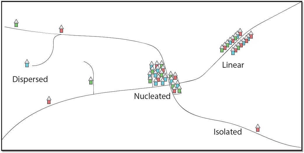
Diagram showing common rural settlement patterns: dispersed homesteads, nucleated villages, linear settlements along transport routes, and isolated farms. The labels clarify how low density and dispersion differ from urban clustering. Source.
Features of Rural Areas
Low population density: Fewer people spread across wide geographic regions.
Primary activities: Farming, forestry, fishing, and other resource-based livelihoods.
Limited infrastructure: Less access to services such as healthcare and education.
Closer connection to environment: Greater reliance on local ecosystems and natural resources.
Out-migration: Younger populations often move to urban areas for education and employment opportunities.
Comparing Urban and Rural Areas
The distinction between urban and rural areas lies in settlement patterns, population density, and infrastructure, but they are interconnected in several ways. Urban centres rely heavily on rural regions for food, water, raw materials, and labour, while rural economies are often shaped by urban demand and investment.
Key Differences
Population density: High in urban areas; low in rural areas.
Settlement patterns: Clustered and compact in cities; scattered and dispersed in rural zones.
Infrastructure: Highly developed in urban systems; minimal in rural environments.
Economic activity: Services and industry dominate urban areas; agriculture and resource extraction dominate rural areas.
The Urban–Rural Continuum
It is important to note that the urban–rural divide is not absolute. Instead, settlements exist along a continuum, with suburban areas and peri-urban zones blending features of both.
Urban–Rural Continuum: A spectrum of settlement types ranging from highly urbanised cities to sparsely populated rural areas, with mixed-use suburban and peri-urban spaces in between.
For example, suburban areas may combine residential housing and green spaces with easy access to urban services, while peri-urban zones often host a mix of agricultural activity and urban sprawl.
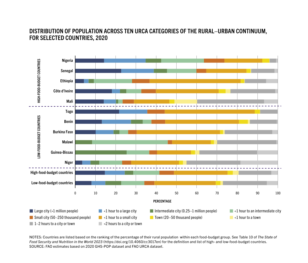
Stacked bar chart illustrating the rural–urban continuum categories (URCA), showing how populations distribute across settlement types from rural to urban. This supports the idea of a graded spectrum rather than a strict binary; the country comparisons are additional context not required by the syllabus. Source.
Cities, Towns, and Suburbs as Urban Areas
The syllabus specifies that cities, towns, and suburbs are all classified as urban.
Cities: Large and complex settlements with extensive infrastructure and diverse economies.
Towns: Smaller than cities but still characterised by clustered settlement and access to services.
Suburbs: Residential zones on the outskirts of cities, with lower density but strong connections to the central urban core.
This classification reflects the functional relationship between settlement types, where suburbs depend on cities, and towns often serve as regional hubs.
Implications of Urban and Rural Definitions
Understanding how areas are defined has major implications for planning, sustainability, and resource management:
Urban policy and planning: Requires recognition of high-density challenges, including housing, waste, and pollution.
Rural development: Focuses on sustainable agriculture, conservation, and preventing depopulation.
Migration analysis: Helps explain push–pull factors influencing rural–urban migration.
Environmental impacts: Urbanisation often leads to loss of farmland and ecosystems, while rural land use may create pressures such as deforestation or soil degradation.
Interconnected Systems
Urban and rural areas should not be seen in isolation. Instead, they form interdependent systems:
Urban centres rely on rural areas for food, raw materials, and labour.
Rural areas depend on urban centres for technology, services, and markets.
Transport networks physically link both, enabling flows of goods and people.
This interconnectedness reinforces the idea that both urban and rural areas contribute to the functioning of larger socio-ecological systems.
Practice Questions
Question 1 (2 marks):
Define what is meant by a rural area.
Mark Scheme:
1 mark for identifying that rural areas have low population density.
1 mark for recognising dispersed settlements or land use primarily linked to agriculture, forestry, or natural resource management.
Question 2 (5 marks):
Explain two key differences between urban and rural areas, and discuss how these differences can influence planning for sustainability.
Mark Scheme:
1 mark for each accurate description of a difference between urban and rural areas (maximum 2 marks). Examples:
Urban areas have high population density; rural areas have low population density.
Urban areas are characterised by clustered, built environments; rural areas by dispersed settlements.
Urban economies rely on services and industry; rural economies rely on agriculture and resource extraction.
1 mark for linking each difference to an implication for planning (maximum 2 marks). Examples:
Urban high density requires housing, waste, and pollution management.
Rural dispersed settlements require transport networks and sustainable agriculture policies.
1 mark for overall discussion of how differences shape sustainability priorities (e.g., balancing resource use, migration pressures, or conserving farmland).
FAQ
There is no single universal definition of urban and rural. Classifications vary by country, often based on population size, density, and the proportion of people engaged in non-agricultural work.
For example:
In some countries, a settlement above 2,000 people is considered urban.
Others use administrative boundaries, infrastructure availability, or employment type.
This means comparisons between nations can be complex.
Suburbs are primarily residential areas located on the edges of cities, usually connected by transport links and heavily reliant on urban centres for services and employment.
Peri-urban areas, however, are zones where rural and urban land uses overlap. They often contain a mix of small-scale farming, housing developments, and expanding infrastructure. Unlike suburbs, peri-urban zones may lack full service integration.
Towns are classified as urban because they display core urban features such as concentrated settlement, organised infrastructure, and access to services like schools and markets.
Even at smaller scales, these features distinguish towns from dispersed rural settlements. Their role as local service and economic hubs supports their classification as part of the urban system.
High population density in urban areas allows for cost-efficient service delivery such as hospitals, schools, and public transport, because demand is concentrated.
In rural areas, low density and dispersed populations make providing the same services more expensive and less efficient, often leading to reduced availability or reliance on regional centres.
The continuum shows that many places are not purely urban or rural, but a mix of both. This can complicate planning decisions.
Challenges include:
Overlapping land uses (housing next to farms).
Conflicts between conservation and development.
Difficulties in providing infrastructure across mixed areas.
Policy gaps, as governance systems often treat urban and rural as separate categories.
