
AP Syllabus focus:
'Advances in navigation, cartography, and military technology enabled Europeans to travel farther and establish overseas colonies and empires.'
During the fifteenth and sixteenth centuries, practical innovations in ships, instruments, mapping, and weapons gave European mariners new reach. These changes made sustained oceanic travel possible and supported the first durable overseas empires.
Why technological change mattered
European overseas expansion did not begin because of one sudden invention. It emerged from a cluster of improvements that made long-distance sea travel more predictable, repeatable, and useful for governments. Medieval sailors had long navigated coasts and crossed parts of the Mediterranean and Atlantic, but truly sustained voyages required more than courage. Mariners needed ships that could survive rough water, instruments that could estimate position, maps that could be updated from experience, and weapons strong enough to defend ships and seize strategic ports.
These advances mattered because they turned isolated voyages into systems. Once rulers could send repeated expeditions, gather reliable information, and protect sea routes, exploration could lead to permanent bases, colonies, and empires rather than one-time contact.
Navigation at sea
Ships built for distance
European mariners benefited from improved ship design. Lighter, more maneuverable vessels could explore unfamiliar coasts, while larger ocean-going ships could carry food, water, cargo, soldiers, and artillery. Two especially important types were the caravel and the carrack.
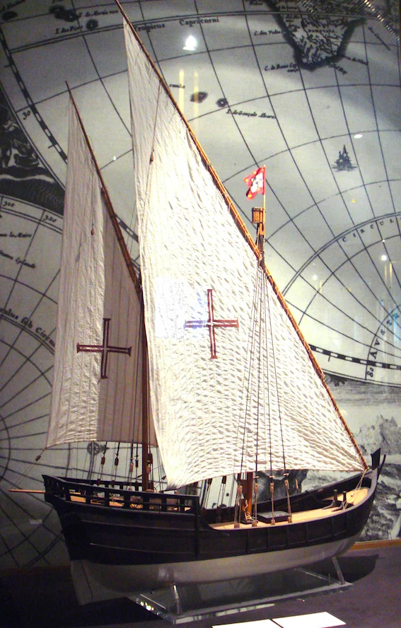
This image shows a model of a Portuguese caravel rigged with lateen (triangular) sails, highlighting the ship type closely associated with early Atlantic exploration. The sail plan emphasizes maneuverability—useful for probing coastlines and working with variable winds. As a compact, purpose-built vessel, the caravel helps explain how design changes translated into practical long-distance voyaging capacity. Source
The caravel was useful for reconnaissance and coastal exploration because it handled well in changing winds. The carrack, with a broader hull, could transport heavier loads across longer distances.
Several design features increased range and safety:
Lateen sails allowed ships to tack more effectively against the wind.
Square sails remained useful for speed when winds were favorable.
The sternpost rudder improved steering.
Stronger hull construction let ships endure Atlantic conditions better than many earlier vessels.
These improvements gave sailors more control over direction and made it possible to cross open water instead of depending entirely on coast-hugging routes.
Instruments and seamanship
Better navigation depended on both tools and accumulated knowledge. The magnetic compass helped sailors maintain direction even when coastlines were not visible. The astrolabe, quadrant, and later related instruments helped estimate latitude by measuring the angle of the sun or stars above the horizon. This did not solve every navigational problem, especially longitude, but it made ocean travel less uncertain.
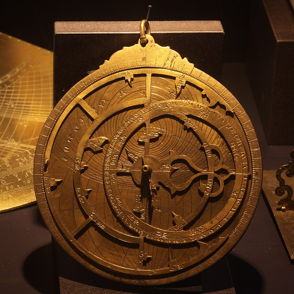
This photograph shows a metal astrolabe, a premodern astronomical instrument adapted for navigation. Mariners used instruments like this to measure the altitude of the sun or a known star above the horizon, enabling an estimate of latitude. Its graduated scale and openwork design reflect a tool meant to be both readable and usable in outdoor conditions. Source
Practical seamanship was just as important. Captains learned to combine instrument readings with dead reckoning, observations of winds, currents, wave patterns, and experience from earlier voyages. Portuguese sailors, in particular, improved Atlantic navigation by mastering wind systems and return routes rather than simply retracing outward journeys. As pilots recorded routes in logs, navigation became more systematic and less dependent on guesswork.
Cartography and geographic knowledge
Advances in cartography strengthened these navigational gains. Medieval maps were often symbolic or religious in emphasis, but explorers needed working charts that showed coastlines, ports, distances, and hazards. As voyages multiplied, mapmakers incorporated new observations into more detailed representations of the world.
One important development was the wider use of portolan charts, which marked coastlines and compass directions for practical navigation.
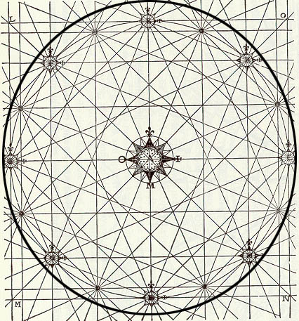
This diagram isolates the rhumb-line network characteristic of portolan charts: a set of radiating and intersecting direction lines aligned to compass headings. Mariners could use these lines to transfer bearings between points, making route planning more systematic. The visual structure helps explain why portolan charts were especially practical for coastal navigation and repeated voyages. Source
Mapmakers also reworked older geographical traditions in light of new evidence from mariners. The result was not perfect accuracy, but maps became more useful for planning and repeating long-distance routes.
Improved maps had political value as well. They helped states identify strategic harbors, organize expeditions, define claims, and visualize overseas possessions. Cartography therefore supported empire by turning scattered discoveries into organized geographic knowledge that rulers could use.
Military technology and imperial footholds
Navigation and mapping alone could not create empires. Europeans also carried increasingly effective gunpowder weapons at sea. Ship-mounted cannon allowed armed vessels to intimidate rivals, protect cargo, and attack coastal settlements or shipping. On land, artillery helped secure fortified positions.
This military edge was especially important in coastal zones. European states could not automatically conquer large inland regions simply because they possessed cannon, but naval firepower often gave them an advantage in seizing islands, harbors, and chokepoints. From these positions, they could control access to sea routes and support later expansion.
Military technology also changed the meaning of a voyage. A ship was not just a means of transport; it was a floating weapons platform that could project power far from Europe. Armed fleets made it easier to establish fortified ports, defend settlers, and enforce imperial claims against competitors.
From voyages to colonies and empires
The combination of better ships, navigational tools, maps, and naval weaponry allowed European powers to travel farther and return more reliably. That reliability was essential. Colonies and empires required repeated crossings to move administrators, settlers, merchants, soldiers, and supplies. Without dependable navigation and route knowledge, distant possessions would have been difficult to maintain.
These technologies also linked exploration to state power. Rulers could sponsor expeditions, gather information from them, and use that information to launch new voyages with greater confidence. In this way, exploration became cumulative: each journey improved the next.
Portuguese expansion along the African coast and into the Indian Ocean, as well as Spanish crossings of the Atlantic, show how technology enabled sustained overseas presence. Europeans still faced storms, shipwreck, resistance, and enormous uncertainty, but they possessed tools that earlier generations lacked. Those tools made long-range maritime expansion practical enough to support the first European overseas colonies and empires.
Practice Questions
Identify two technological advances that helped Europeans travel farther overseas in the fifteenth and sixteenth centuries. (2 marks)
1 mark for identifying any one relevant advance, such as the magnetic compass, astrolabe, quadrant, improved cartography, caravel, carrack, lateen sail, or sternpost rudder.
1 additional mark for identifying a second relevant advance.
Explain how improvements in navigation, cartography, and military technology enabled European states to establish overseas colonies and empires in the fifteenth and sixteenth centuries. (5 marks)
1 mark for explaining that improved ship design made longer ocean voyages more practical.
1 mark for explaining that navigational instruments reduced uncertainty and helped sailors maintain direction or estimate latitude.
1 mark for explaining that improved cartography made routes easier to plan, repeat, and control.
1 mark for explaining that gunpowder weapons, especially ship-mounted cannon, helped Europeans seize or defend ports and sea lanes.
1 mark for linking these advances to the establishment or maintenance of colonies and empires through repeated crossings, transport of supplies, or enforcement of state claims.
FAQ
Longitude required knowing the time difference between a ship’s location and a fixed reference point. Early modern sailors did not yet have clocks accurate enough to keep time reliably on long ocean voyages.
As a result, mariners could estimate latitude with reasonable confidence, but longitude often remained approximate. This is one reason why ships could still miss islands, drift off course, or take much longer routes than intended.
Rutters were written sailing directions used alongside charts. They described practical details that a map alone might not show clearly.
They often included:
coastal landmarks
currents and winds
dangerous shoals or reefs
distances between ports
recommended routes in different seasons
Because they were based on experience, rutters were especially valuable for pilots entering unfamiliar waters.
Atlantic islands acted as stepping stones for experimentation. They gave sailors places to resupply, repair ships, and test new routes before attempting longer crossings.
They also helped Europeans learn:
how Atlantic wind systems worked
how to organise return voyages
how to maintain distant bases over water
In this sense, islands were not just destinations; they were training grounds for wider imperial expansion.
Both crowns often treated geographical knowledge as a strategic asset. Maps, sailing directions, and reports could be restricted because they revealed routes, harbours, and commercial opportunities.
This secrecy had mixed effects:
it protected valuable information from rivals
it strengthened royal control over exploration
it could slow the wider circulation of knowledge
Mapmaking was therefore not only scientific or practical; it was also political.
Naval guns were most effective where ships could directly support military action: harbours, estuaries, islands, and coastal towns. In those places, fleets could bombard targets, land troops, and supply forts.
Farther inland, that advantage weakened. Armies had to move away from the coast, carry supplies overland, and face environments and opponents that ships could not easily reach.
This is why maritime power often produced chains of ports and forts before it produced large inland empires.