
AP Syllabus focus: ‘In the Americas and in Africa, state systems showed continuity, innovation, and diversity and expanded in scope and reach.’
State expansion from c. 1200 to c. 1450 can be compared across the Americas and Africa by examining how polities grew, integrated diverse peoples, and legitimized authority under different environmental and economic constraints.
Core comparison: how states expanded
What “expansion” looked like in each region
Both regions saw states increase territorial reach, intensify governance, and project power beyond a capital or core zone.
State expansion: the growth of a polity’s territorial control and administrative influence, achieved through conquest, alliance, incorporation of communities, and/or stronger systems of taxation, tribute, and law.
Shared drivers across the Americas and Africa
Military capacity: stronger armies and leadership enabled conquest and intimidation.
Economic incentives: control of trade routes, resource zones, and productive farmland encouraged outward growth.
Political consolidation: rulers expanded to secure borders and reduce rivals.
Ideology and legitimacy: religious or sacred authority often justified domination and demanded loyalty.
Continuity, innovation, and diversity (comparative lens)
Continuity: building on older political traditions
In both regions, states often relied on enduring practices such as tribute/tax collection, elite hierarchies, and ritual authority to bind communities to the center.
Expansion frequently preserved local leadership structures as long as communities met obligations (goods, labor, military service).
Innovation: new tools for ruling larger spaces
Administrative innovations supported growth:
More systematic recordkeeping (whether oral, material, or written, depending on the polity).
Standardized obligations (regular tribute, labor quotas, or market dues).
Infrastructure and communication helped states reach peripheries:
Roads, waystations, and planned urban centers (where present) reduced the “distance cost” of rule.
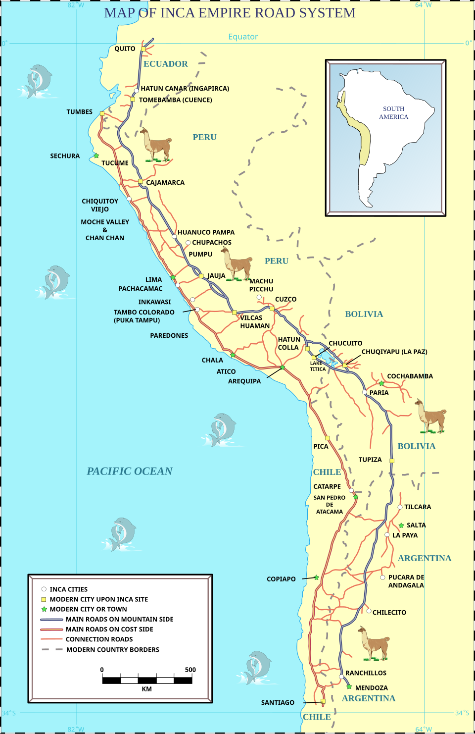
This map shows the Inca road system (Qhapaq Ñan) spanning much of the Andes, with major routes and connections across varied terrain. It illustrates how road infrastructure enabled imperial administration, troop movement, and tribute logistics across an environmentally challenging landscape. In comparative terms, it is a concrete example of how states reduced the friction of distance to consolidate authority beyond the core. Source
Flexible incorporation strategies:
Combining force with alliances and negotiated submission expanded control without constant warfare.
Diversity: multiple pathways to expansion
State expansion did not follow one model in either region.
Some polities expanded as territorial empires with direct oversight in key zones.
Others expanded influence through networks:
Federations, city clusters, or commercial hubs that controlled surrounding areas indirectly.
Political scale varied widely, from localized systems to large multi-ethnic empires.
Mechanisms of integration and control
Extracting resources: tribute, taxation, and labor
Across both regions, expansion was sustainable only if rulers could reliably mobilize resources.
Tribute/taxes: goods (food, craft items, prestige goods) and sometimes currency where used.
Labor systems: required work for state projects (roads, fortifications, elite building programs).
Redistribution: rulers strengthened loyalty by reallocating tribute during ceremonies, crises, or military campaigns.
Managing cultural and geographic diversity
As states expanded, they confronted varied languages, identities, and ecologies.
Indirect rule was common: local elites retained status in exchange for compliance.
Symbolic integration: public ritual, sacred kingship, and monumental architecture promoted a shared political order.
Strategic settlement: moving administrators, soldiers, or loyal communities into sensitive regions tightened control.
Environmental and economic constraints shaping expansion
The Americas: geography and limited Old World-style connectivity
Mountain ranges, rainforests, and deserts could make integration costly, encouraging strong state investment in transport corridors and planned nodes of control.
Without extensive large-animal transport in many areas, states often relied heavily on human labor and tightly organized provisioning.
Africa: regional trade linkages and ecological zones
Expansion frequently followed access to regional trade (across deserts, savannas, and coasts), rewarding states that could secure routes and enforce tolls.
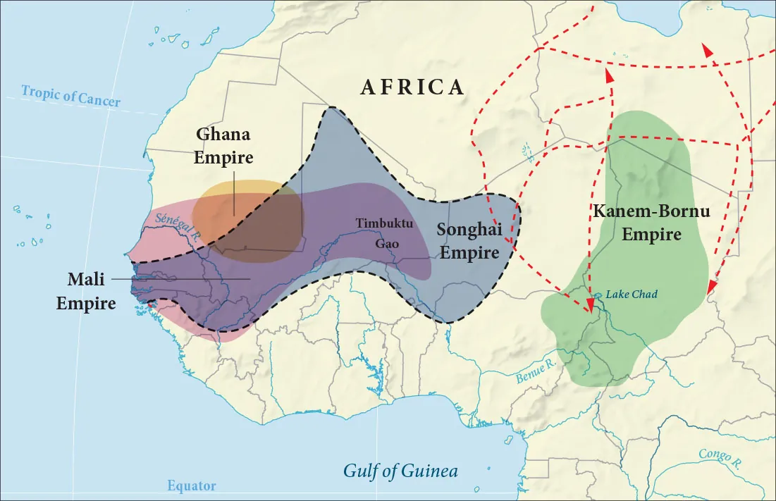
This map visualizes major Sudanic empires alongside trans-Saharan trade routes, highlighting how political power and commercial corridors overlapped in West and Central Africa. It helps explain why controlling caravan routes, key cities, and exchange networks could translate into territorial reach and state capacity. The diagram reinforces the idea that African expansion often followed trade geography as much as conquest geography. Source
Ecological variety encouraged diverse political forms, from centralized kingdoms to looser systems adapted to mobility and local production.
Practice Questions
Identify one similarity in how states expanded in the Americas and Africa in the period c. 1200–1450. (2 marks)
1 mark for identifying a valid similarity (e.g., use of tribute/tax, military conquest, or ideology to justify rule).
1 mark for a brief accurate elaboration linking the similarity to expansion (e.g., tribute enabled sustained armies/administration).
Compare and explain two ways state expansion showed both innovation and diversity across the Americas and Africa (c. 1200–1450). Use specific historical evidence. (6 marks)
1 mark for a defensible comparative claim addressing innovation and/or diversity.
2 marks for explaining one innovative method of expansion/control with relevant evidence.
2 marks for explaining a second innovative or diverse pathway with relevant evidence from the other region or a contrasting polity type.
1 mark for explicitly linking the examples to how expansion increased scope/reach (integration, extraction, administration).
FAQ
Geography shaped transport costs and the ease of supplying armies and officials.
In the Americas, extreme vertical environments could encourage intensive road-and-node solutions. In Africa, broad ecological belts often pushed states to prioritise route security and adaptable frontier control.
Common indicators include:
Standardised building layouts or elite architecture beyond a core zone
Distribution of state-style ceramics or prestige goods
Fortifications and road traces
Changes in settlement hierarchy (new administrative centres)
No. Many states expanded influence without fully administering every community.
Indirect approaches included vassalage, tribute relationships, hostage-taking, marriage alliances, and allowing local rulers to govern if obligations were met.
Vector-borne disease zones could restrict dense settlement and sustained campaigning.
States often focused on controlling healthier corridors, seasonal routes, and trade chokepoints rather than permanent occupation of all frontier areas.
Specialised crafts could supply prestige goods that underwrote loyalty and hierarchy.
Control of workshops, standards of production, and long-distance exchange of high-status items helped rulers reward allies, fund institutions, and signal legitimacy across wider territories.
